
It is looking likely that southeastern Pennsylvania and parts of New Jersey will get at least some snow Sunday into Monday, according to National Weather Service, but a lot more is now looking possible.
Friday afternoon the NWS issued a winter storm watch for Sunday morning into Monday afternoon for the region.
The NWS early Friday morning messaging said two scenarios are depicted in current models.
“A pass closer to the coast would mean more impacts with coastal flooding, wind, snow/wintry mix, and marine navigation concerns,” the 4:45 a.m. report stated. “A pass farther southeast would mean still some light wintry precipitation (mostly snow), but lower winds, less risk of widespread tidal flooding, and less impacts overall.”
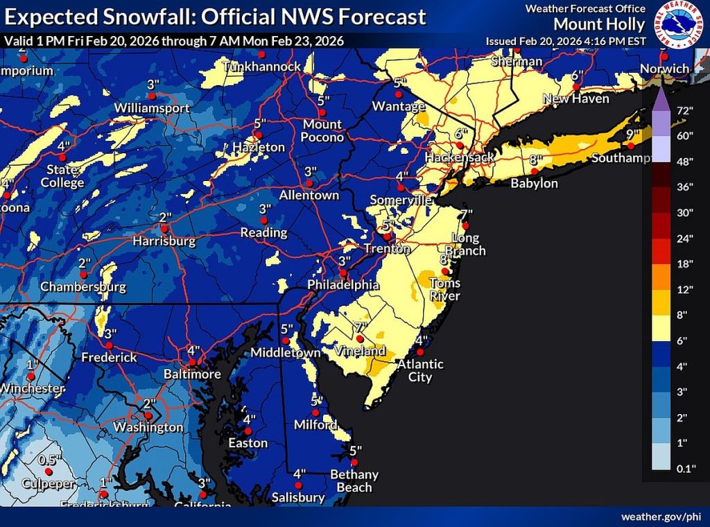
Friday afternoon the forecasted accumulation was upped to 4 to 6 inches northwest of Interstate 95 and as much as 6 to 10 inches southeast of I-95.
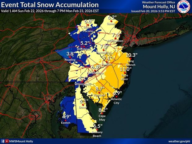 The National Weather Service snow accumulation prediction for the storm moving through the Philly region Sunday, Feb. 22, 2026 to Monday, Feb. 23 that was issued Friday afternoon, Feb. 20. (Courtesy of the National Weather Story)
Heavy snow with winds gusts up to 35 mph is expected the watch said, making travel difficult.
“The current expectation is for light precipitation to begin overspreading the region from southwest to northeast some time overnight Saturday night,” the afternoon discussion stated. “As the low begins to approach from the southwest Sunday afternoon, precipitation rates should begin to increase. Temperatures during the daytime hours on Sunday are expected to be fairly warm, so precipitation will likely be rain or a rain and snow mix for most of the day.
“Sunday night, colder air will begin to infiltrate the area in concert with the heaviest precipitation rates. Therefore, precipitation is likely to change to all snow, and be heavy at times. Snow will likely come to an end from west to east by Monday afternoon.”
National Weather Service forecast
Tonight: Mostly cloudy, with a low around 35. West wind around 5 mph.
Saturday: Partly sunny, with a high near 47. West wind 5 to 10 mph.
Saturday night: A chance of rain and snow between 1 and 4 a.m., then a chance of snow after 4 a.m. Increasing clouds, with a low around 31. Calm wind. Chance of precipitation is 30%. Little or no snow accumulation expected.
Sunday: Snow, possibly mixed with rain, becoming all snow after 4 p.m. High near 39. East wind 5 to 10 mph. Chance of precipitation is 90%. New snow accumulation of less than 1 inch possible.
Sunday night: Snow. Low around 30. Chance of precipitation is 80%.
Monday: A chance of snow before 1 p.m. Mostly cloudy, with a high near 39. Chance of precipitation is 30%.
Monday night: Mostly cloudy, with a low around 25.