
Snow could be heavy in some areas
MARYELLEN PANN. WELL, IT’LL BE A QUIET START TO THE WEEKEND, SO TODAY’S THE DAY TO GET OUT AND RUN AROUND, MAKE DO SOME ERRANDS, HEAD TO SOME OF THE LOCAL EVENTS THAT ARE HAPPENING. THINGS ARE GOING TO CHANGE FOR TOMORROW AS A WINTER STORM MAKES ITS WAY TO THE COAST, AND THERE IS A WINTER WEATHER ADVISORY IN EFFECT NOW AT 5 A.M. TOMORROW MORNING, AND NOW INCLUDES PERRY AND CUMBERLAND COUNTIES. AND THAT’S WHERE ALL THE COUNTIES HERE IN BLUE EXTENDING DOWN INTO MARYLAND. BUT OFF TO THE WEST FROM CHESTER COUNTY ON OVER TOWARDS PHILADELPHIA IN THE EASTERN PART OF THE STATE. THEY’VE BEEN UPGRADED TO A WINTER STORM WARNING THAT GOES INTO EFFECT TOMORROW MORNING UNTIL MONDAY AT 1:00. AND THAT’S WHERE WE ANTICIPATE THE HIGHER SNOW AMOUNTS OFF TO THE EAST. SO THIS IS GOING TO BE A MODERATE IMPACT STORM DEVELOPING OVERNIGHT TOWARDS THE MORNING HOURS COULD HAVE SOME SNOW MIXING A LITTLE BIT INTO THE AFTERNOON. BUT ONCE THE SUN SETS THEN THAT SNOW IS GOING TO PICK UP IN INTENSITY, BECOMING MORE MODERATE TO EVEN HEAVY AT TIMES IN THE OVERNIGHT PERIOD. AND THAT WILL CONTINUE INTO THE EARLY PART OF MONDAY, MAYBE LINGERING IN OUR EASTERN COUNTIES A LITTLE BIT LONGER. SO WE’RE TALKING ABOUT WET TO SLUSHY ROADS, SOME SNOW DURING THE DAYTIME HOURS, BUT AT NIGHT THEY WILL BECOME SLUSHY TO SNOW COVERED. AND THAT WILL CONTINUE INTO EARLY MONDAY MORNING. AND WE’RE STILL LOOKING AT 2 TO 5IN FOR MAJORITY OF THE AREA. BUT NOTICE HERE ACROSS LANCASTER AND YORK, IN THE SOUTHERN AND SOUTHEASTERN PORTIONS AND ON TO THE EAST, THIS IS WHERE WE COULD SEE 5 TO 8IN. AND I WANT TO EMPHASIZE THIS MAY CHANGE. THIS LINE COULD EITHER MOVE TO THE WEST OR IT COULD BE MOVING TO THE EAST, DEPENDING ON WHERE THAT LOW DEVELOPS. OFF THE COAST, HALF THE MODELS HAVE IT CLOSE ENOUGH TO BRING THOSE HIGHER SNOW TOTALS IN. OTHER MODELS HAVE IT JUST FAR ENOUGH TO THE EAST THAT WE WOULD SEE THE HIGHER SNOW TOTALS CLOSER TO THE COASTLINE. SO OF COURSE WE’RE GOING TO KEEP YOU POSTED ON THAT. TEMPERATURES RIGHT NOW, 39 IN LEWISTOWN, 37 IN CHAMBERSBURG. WE HAVE 36 IN HARRISBURG AND 35 IN LANCASTER. WINDS ARE PICKING UP IN LEWISTOWN. THAT’S WHY WE SEE WARMER TEMPERATURES THERE. SIX MILE PER HOUR WIND THERE IN CARLISLE, LANCASTER AND ALSO IN HARRISBURG. SO YOUR NEWS EIGHT STORM TEAM FORECAST CALLS FOR TEMPERATURES TO HEAD TO 44 DEGREES WITH A MIX OF CLOUDS AND SUNSHINE. THAT’S ACTUALLY WHERE WE SHOULD BE FOR THIS TIME OF YEAR. CLOUDS WILL INCREASE OVERNIGHT TONIGHT. THAT SNOW POSSIBLY EVEN MIXING, WILL DEVELOP AND WE’LL SEE TEMPERATURES HOVERING RIGHT AROUND FREEZING, IF NOT JUST ABOVE FREEZING. AND REALLY, TEMPERATURES WILL STAY IN THE LOW TO MID 30S FOR MUCH OF THE DAY TOMORROW. THE BEST CHANCE FOR THAT MIXING WILL BE DURING THE DAYLIGHT HOURS, WITH THE HEAVIEST COMING IN LATE AFTER THE SUN SETS. TEMPERATURES REALLY HOLDING STEADY. IT’S QUIET OUT THERE RIGHT NOW. OUR STORM SYSTEM IS STILL OFF TO THE SOUTHWEST ACROSS THE GULF COAST REGION. IT’S GOING TO PICK UP SOME MOISTURE. WE’VE GOT SOME UPPER LEVEL ENERGY COMING IN, AND THIS LOW IS GOING TO MOVE OFF THE COAST OF NORTH CAROLINA AND THEN HEAD TO THE NORTHEAST. AND WHERE IT INTENSIFIES OFF THE DELMARVA COAST IS GOING TO BE VERY CRUCIAL TO WHERE THOSE HEAVY SNOW BANDS SET UP A LITTLE FURTHER INLAND. SO THAT’S WHAT WE’RE GOING TO BE KEEPING A CLOSE EYE ON HERE. AS THE MODEL RUNS CONTINUE TO COME OUT TODAY. HERE’S A LOOK AT PREDICTOR. THIS PARTICULAR MODEL SHOWING A NICE LOOKING DAY TODAY WITH THE MIX OF SUN AND CLOUDS. THOSE CLOUDS BUILD ON IN. YOU CAN SEE TEMPERATURES AT 3 A.M. AT 33 DEGREES. WITH THAT SNOW DEVELOPING AND POSSIBLY MIXING MIXING THROUGHOUT THE DAY. BUT ONCE THAT SUN SETS, WE START TO SEE THAT SNOW PICKING UP IN INTENSITY. AND HERE COMES OUR LOW SITTING JUST OFF THE COAST. AND YOU’LL NOTICE THIS WHITE BRIGHT BAND HERE WHERE THE HEAVIEST SNOW WILL BE SETTING UP, BUT STILL GIVING US ACCUMULATING SNOW SUNDAY NIGHT INTO EARLY MONDAY. AND THEN IT STARTS TO WRAP UP EARLY IN THE MORNING AS THE SYSTEM PULLS AWAY. COULD HAVE SOME LAKE EFFECT SNOW SHOWERS ACROSS THE AREA ON MONDAY. OTHERWISE, WE’RE LOOKING AT PARTLY SUNNY SKIES. ROAD CONDITIONS WILL CONTINUE TO DETERIORATE TOMORROW MORNING. WET TO SLUSHY, WET TO SLUSHY TO MINOR COATING AS WE HEAD INTO THE EVENING AND THEN OVERNIGHT INTO MONDAY. SLUSHY TO SNOW COVERED. TEN DAY FORECAST SHOWS TEMPERATURES IN THE MID 30S ON MONDAY, BUT IT WILL BE BLUSTERY. WE’RE TALKING LOW 30S ON TUESDAY. WE JUMP TO THE 40S ON WEDNESDAY.
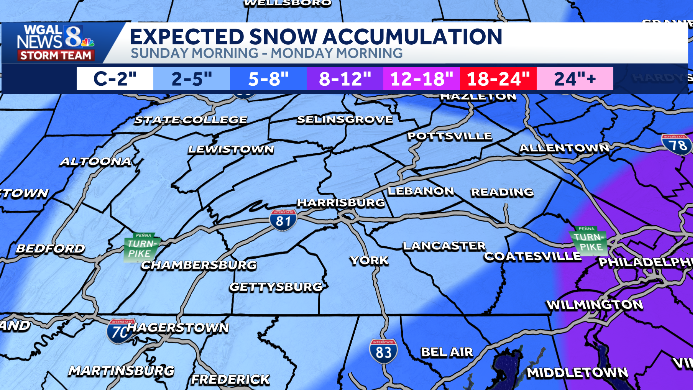
Several inches of snow, or more, are possible Sunday into early Monday across South-Central Pennsylvania as a winter storm develops off the Mid-Atlantic coast.Watches and warningsWinter storm watch: 5 a.m. Sunday to 1 p.m. Monday for most of the Susquehanna Valley — Perry, Cumberland, Adams, Berks, Dauphin, Lancaster, Lebanon, Schuylkill, and York counties.Winter Storm Warning: Chester County has been upgraded (higher snow amounts expected).TimingAfter midnight Saturday–early Sunday morning: light snow develops across the Susquehanna Valley (may mix with sleet or rain at times).Sunday daytime: surface temperatures likely above freezing — roads mainly wet to slushy.Sunday evening–early Monday: precipitation becomes mostly snow; snow continues overnight into early Monday with the highest impacts after sunset.Snow totalsMost of the Susquehanna Valley: 2–5 inches.Highest totals south and east of I‑81.A few locations (southern York and Lancaster counties) could see 5–8 inches.Chester County: expect locally higher amounts under the winter storm warning.Impacts and travelDaytime commutes Sunday likely wet/slushy; nighttime travel could be slushy to snowy and slower.Be prepared for reduced visibility and plow operations if heavier snow develops.SOUTH-CENTRAL PA WEATHER RESOURCES: INTERACTIVE RADAR | ACTIVE WEATHER ALERTS | CURRENT CONDITIONS | HOURLY FORECAST | 10-DAY FORECAST | WEEKEND FORECAST | MAP ROOM | DOWNLOAD THE APP | WEATHER EMAILSWatches vs warningsKnowing the difference between severe watches and warnings is crucial to helping you and your family stay safe before and during severe weather.A watch means ingredients are in place for severe weather to develop. This means severe weather could happen, and you should have a plan ready in case severe weather develops later in the day.A warning means severe weather is happening, and you need to take action now to protect yourself, others and your property.
Several inches of snow, or more, are possible Sunday into early Monday across South-Central Pennsylvania as a winter storm develops off the Mid-Atlantic coast.
Watches and warnings
Winter storm watch: 5 a.m. Sunday to 1 p.m. Monday for most of the Susquehanna Valley — Perry, Cumberland, Adams, Berks, Dauphin, Lancaster, Lebanon, Schuylkill, and York counties.Winter Storm Warning: Chester County has been upgraded (higher snow amounts expected).

TimingAfter midnight Saturday–early Sunday morning: light snow develops across the Susquehanna Valley (may mix with sleet or rain at times).Sunday daytime: surface temperatures likely above freezing — roads mainly wet to slushy.Sunday evening–early Monday: precipitation becomes mostly snow; snow continues overnight into early Monday with the highest impacts after sunset.

Snow totalsMost of the Susquehanna Valley: 2–5 inches.Highest totals south and east of I‑81.A few locations (southern York and Lancaster counties) could see 5–8 inches.Chester County: expect locally higher amounts under the winter storm warning.

Impacts and travelDaytime commutes Sunday likely wet/slushy; nighttime travel could be slushy to snowy and slower.Be prepared for reduced visibility and plow operations if heavier snow develops.

SOUTH-CENTRAL PA WEATHER RESOURCES: INTERACTIVE RADAR | ACTIVE WEATHER ALERTS | CURRENT CONDITIONS | HOURLY FORECAST | 10-DAY FORECAST | WEEKEND FORECAST | MAP ROOM | DOWNLOAD THE APP | WEATHER EMAILS

Watches vs warnings
Knowing the difference between severe watches and warnings is crucial to helping you and your family stay safe before and during severe weather.
A watch means ingredients are in place for severe weather to develop. This means severe weather could happen, and you should have a plan ready in case severe weather develops later in the day.
A warning means severe weather is happening, and you need to take action now to protect yourself, others and your property.