
MARYELLEN PANN. WELL, IT’LL BE A QUIET START TO THE WEEKEND, SO TODAY’S THE DAY TO GET OUT AND RUN AROUND, MAKE DO SOME ERRANDS, HEAD TO SOME OF THE LOCAL EVENTS THAT ARE HAPPENING. THINGS ARE GOING TO CHANGE FOR TOMORROW AS A WINTER STORM MAKES ITS WAY TO THE COAST, AND THERE IS A WINTER WEATHER ADVISORY IN EFFECT NOW AT 5 A.M. TOMORROW MORNING, AND NOW INCLUDES PERRY AND CUMBERLAND COUNTIES. AND THAT’S WHERE ALL THE COUNTIES HERE IN BLUE EXTENDING DOWN INTO MARYLAND. BUT OFF TO THE WEST FROM CHESTER COUNTY ON OVER TOWARDS PHILADELPHIA IN THE EASTERN PART OF THE STATE. THEY’VE BEEN UPGRADED TO A WINTER STORM WARNING THAT GOES INTO EFFECT TOMORROW MORNING UNTIL MONDAY AT 1:00. AND THAT’S WHERE WE ANTICIPATE THE HIGHER SNOW AMOUNTS OFF TO THE EAST. SO THIS IS GOING TO BE A MODERATE IMPACT STORM DEVELOPING OVERNIGHT TOWARDS THE MORNING HOURS COULD HAVE SOME SNOW MIXING A LITTLE BIT INTO THE AFTERNOON. BUT ONCE THE SUN SETS THEN THAT SNOW IS GOING TO PICK UP IN INTENSITY, BECOMING MORE MODERATE TO EVEN HEAVY AT TIMES IN THE OVERNIGHT PERIOD. AND THAT WILL CONTINUE INTO THE EARLY PART OF MONDAY, MAYBE LINGERING IN OUR EASTERN COUNTIES A LITTLE BIT LONGER. SO WE’RE TALKING ABOUT WET TO SLUSHY ROADS, SOME SNOW DURING THE DAYTIME HOURS, BUT AT NIGHT THEY WILL BECOME SLUSHY TO SNOW COVERED. AND THAT WILL CONTINUE INTO EARLY MONDAY MORNING. AND WE’RE STILL LOOKING AT 2 TO 5IN FOR MAJORITY OF THE AREA. BUT NOTICE HERE ACROSS LANCASTER AND YORK, IN THE SOUTHERN AND SOUTHEASTERN PORTIONS AND ON TO THE EAST, THIS IS WHERE WE COULD SEE 5 TO 8IN. AND I WANT TO EMPHASIZE THIS MAY CHANGE. THIS LINE COULD EITHER MOVE TO THE WEST OR IT COULD BE MOVING TO THE EAST, DEPENDING ON WHERE THAT LOW DEVELOPS. OFF THE COAST, HALF THE MODELS HAVE IT CLOSE ENOUGH TO BRING THOSE HIGHER SNOW TOTALS IN. OTHER MODELS HAVE IT JUST FAR ENOUGH TO THE EAST THAT WE WOULD SEE THE HIGHER SNOW TOTALS CLOSER TO THE COASTLINE. SO OF COURSE WE’RE GOING TO KEEP YOU POSTED ON THAT. TEMPERATURES RIGHT NOW, 39 IN LEWISTOWN, 37 IN CHAMBERSBURG. WE HAVE 36 IN HARRISBURG AND 35 IN LANCASTER. WINDS ARE PICKING UP IN LEWISTOWN. THAT’S WHY WE SEE WARMER TEMPERATURES THERE. SIX MILE PER HOUR WIND THERE IN CARLISLE, LANCASTER AND ALSO IN HARRISBURG. SO YOUR NEWS EIGHT STORM TEAM FORECAST CALLS FOR TEMPERATURES TO HEAD TO 44 DEGREES WITH A MIX OF CLOUDS AND SUNSHINE. THAT’S ACTUALLY WHERE WE SHOULD BE FOR THIS TIME OF YEAR. CLOUDS WILL INCREASE OVERNIGHT TONIGHT. THAT SNOW POSSIBLY EVEN MIXING, WILL DEVELOP AND WE’LL SEE TEMPERATURES HOVERING RIGHT AROUND FREEZING, IF NOT JUST ABOVE FREEZING. AND REALLY, TEMPERATURES WILL STAY IN THE LOW TO MID 30S FOR MUCH OF THE DAY TOMORROW. THE BEST CHANCE FOR THAT MIXING WILL BE DURING THE DAYLIGHT HOURS, WITH THE HEAVIEST COMING IN LATE AFTER THE SUN SETS. TEMPERATURES REALLY HOLDING STEADY. IT’S QUIET OUT THERE RIGHT NOW. OUR STORM SYSTEM IS STILL OFF TO THE SOUTHWEST ACROSS THE GULF COAST REGION. IT’S GOING TO PICK UP SOME MOISTURE. WE’VE GOT SOME UPPER LEVEL ENERGY COMING IN, AND THIS LOW IS GOING TO MOVE OFF THE COAST OF NORTH CAROLINA AND THEN HEAD TO THE NORTHEAST. AND WHERE IT INTENSIFIES OFF THE DELMARVA COAST IS GOING TO BE VERY CRUCIAL TO WHERE THOSE HEAVY SNOW BANDS SET UP A LITTLE FURTHER INLAND. SO THAT’S WHAT WE’RE GOING TO BE KEEPING A CLOSE EYE ON HERE. AS THE MODEL RUNS CONTINUE TO COME OUT TODAY. HERE’S A LOOK AT PREDICTOR. THIS PARTICULAR MODEL SHOWING A NICE LOOKING DAY TODAY WITH THE MIX OF SUN AND CLOUDS. THOSE CLOUDS BUILD ON IN. YOU CAN SEE TEMPERATURES AT 3 A.M. AT 33 DEGREES. WITH THAT SNOW DEVELOPING AND POSSIBLY MIXING MIXING THROUGHOUT THE DAY. BUT ONCE THAT SUN SETS, WE START TO SEE THAT SNOW PICKING UP IN INTENSITY. AND HERE COMES OUR LOW SITTING JUST OFF THE COAST. AND YOU’LL NOTICE THIS WHITE BRIGHT BAND HERE WHERE THE HEAVIEST SNOW WILL BE SETTING UP, BUT STILL GIVING US ACCUMULATING SNOW SUNDAY NIGHT INTO EARLY MONDAY. AND THEN IT STARTS TO WRAP UP EARLY IN THE MORNING AS THE SYSTEM PULLS AWAY. COULD HAVE SOME LAKE EFFECT SNOW SHOWERS ACROSS THE AREA ON MONDAY. OTHERWISE, WE’RE LOOKING AT PARTLY SUNNY SKIES. ROAD CONDITIONS WILL CONTINUE TO DETERIORATE TOMORROW MORNING. WET TO SLUSHY, WET TO SLUSHY TO MINOR COATING AS WE HEAD INTO THE EVENING AND THEN OVERNIGHT INTO MONDAY. SLUSHY TO SNOW COVERED. TEN DAY FORECAST SHOWS TEMPERATURES IN THE MID 30S ON MONDAY, BUT IT WILL BE BLUSTERY. WE’RE TALKING LOW 30S ON TUESDAY. WE JUMP TO THE 40S ON WEDNESDAY.
Quiet, dry today; Winter Storm brings snow, snow mix Sunday for South-Central Pennsylvania
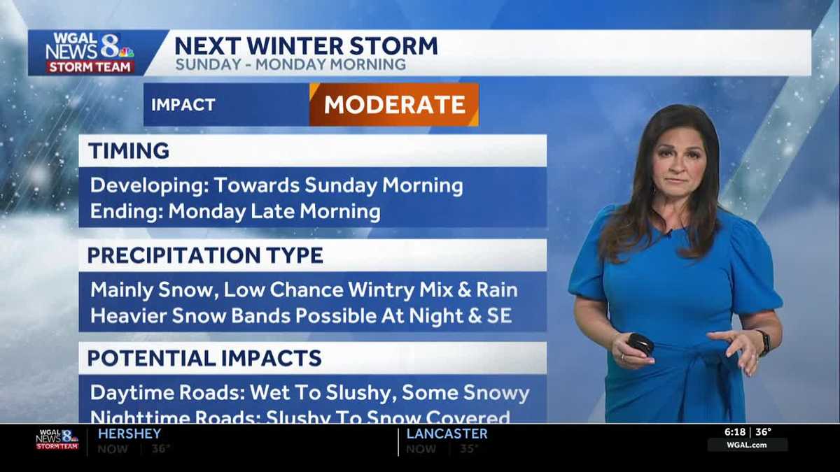
A winter storm is expected to bring accumulating snow to the Susquehanna Valley beginning Sunday morning and continuing through Sunday night.
The Winter Storm Watch is in effect for most of the Susquehanna Valley from 5 a.m. Sunday until 1 p.m.

Updated: 6:47 AM EST Feb 21, 2026
Today will bring a mix of clouds and sunshine, with seasonable afternoon highs around 44 degrees. Winds will be light to moderate, ranging from 5 to 15 mph, making for a typical late-winter day.WINTER STORM WATCH:The National Weather Service has issued a winter storm watch for parts of the Susquehanna Valley from 5 a.m. Sunday to 1 p.m. Monday for Perry, Cumberland, Adams, Berks, Dauphin, Lancaster, Lebanon, Schuylkill, and York counties. Chester County has been upgraded to a Winter Storm Warning where higher snow amounts are expected. Heavy snow is possible as a winter storm develops off the Mid-Atlantic coast.IMPACT SUNDAY INTO EARLY MONDAY:Low pressure will move off the coast of North Carolina and Virginia early Sunday. Expect light snow to develop in the Susquehanna Valley after midnight tonight through early Sunday afternoon. The snow may mix with rain or sleet at times. Surface temperatures will be above freezing during the day, so roads will likely be wet to slushy. Once the sun sets, we’ll see mainly snow. The chance of snow continues Sunday night into early Monday. Overnight, roads may be slushy to snowy. The majority of the Susquehanna Valley can expect 2-5″ of snow with the highest totals south & east of I-81. A few locations may pick up 5-8″ in southern York and Lancaster counties.NEXT WEEK:Colder temperatures in the low-to-mid 30s are in store on Monday and Tuesday. Add a blustery breeze, and it will feel like the 20s.Temperatures moderate to the low 40s on Wednesday, and rain chances increase from late Wednesday into Thursday. Highs will reach the mid-40s on Thursday.Slightly cooler temperatures are in store for Friday, then the following weekend looks dry and pleasant, with highs in the mid-40s.Have a great day!
Today will bring a mix of clouds and sunshine, with seasonable afternoon highs around 44 degrees. Winds will be light to moderate, ranging from 5 to 15 mph, making for a typical late-winter day.
WINTER STORM WATCH:
The National Weather Service has issued a winter storm watch for parts of the Susquehanna Valley from 5 a.m. Sunday to 1 p.m. Monday for Perry, Cumberland, Adams, Berks, Dauphin, Lancaster, Lebanon, Schuylkill, and York counties. Chester County has been upgraded to a Winter Storm Warning where higher snow amounts are expected. Heavy snow is possible as a winter storm develops off the Mid-Atlantic coast.
IMPACT SUNDAY INTO EARLY MONDAY:
Low pressure will move off the coast of North Carolina and Virginia early Sunday. Expect light snow to develop in the Susquehanna Valley after midnight tonight through early Sunday afternoon. The snow may mix with rain or sleet at times. Surface temperatures will be above freezing during the day, so roads will likely be wet to slushy. Once the sun sets, we’ll see mainly snow.
The chance of snow continues Sunday night into early Monday. Overnight, roads may be slushy to snowy. The majority of the Susquehanna Valley can expect 2-5″ of snow with the highest totals south & east of I-81. A few locations may pick up 5-8″ in southern York and Lancaster counties.
NEXT WEEK:
Colder temperatures in the low-to-mid 30s are in store on Monday and Tuesday. Add a blustery breeze, and it will feel like the 20s.
Temperatures moderate to the low 40s on Wednesday, and rain chances increase from late Wednesday into Thursday. Highs will reach the mid-40s on Thursday.
Slightly cooler temperatures are in store for Friday, then the following weekend looks dry and pleasant, with highs in the mid-40s.
Have a great day!