

The Philadelphia region — along with up to 40 million Americans across the U.S. — is bracing for a powerful coastal storm that will begin Sunday and continue through late Monday.
Significant snowfall, high winds and coastal flooding are expected across the Delaware Valley, just as snowfall from January’s major storm, which dumped over 9 inches of snow on the city, has finally melted.
What’s the latest forecast?
Sunday’s winter storm may bring between 14 and 18 inches of snow to Philadelphia, its suburbs and parts of Delaware, the National Weather Service reports. Wind gusts as high as 40 mph are expected.
South Jersey, meanwhile, may see between 14 and 20 inches of snow, per the NWS, along with wind gusts up to 45 mph.
Meteorologists with WHYY News partner 6abc are more conservative in their estimates, predicting between 8 and 12 inches of snow in the Philadelphia area, parts of South Jersey and parts of Delaware, with over 12 inches possible along coastal areas.
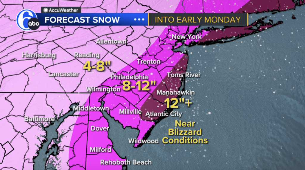 Significant snowfall is expected across the Philadelphia region, with the heaviest accumulation anticipated Sunday evening. (6abc)
Rain and snow showers are in the forecast for Sunday morning, with a high of 39 degrees, though areas northwest of Philadelphia may see light snow showers. As temperatures drop, precipitation is expected to transition to snow by the evening.
The heaviest snowfall is expected Sunday night, 6abc meteorologists report.
Snow is expected to taper off west to east by Monday morning as the storm continues to strengthen and move away from the coast.
Coastal flooding is most likely from Delaware to Cape Cod, the NWS reports.
Weather alerts, watches and advisories