
ALERT: Light to heavy snow mix for Sunday across south-central Pennsylvania
A Winter Storm Warning is in effect for parts of the majority of the Valley. A winter storm is expected to bring accumulating snow to the Susquehanna Valley beginning Sunday morning and continuing through Sunday night.
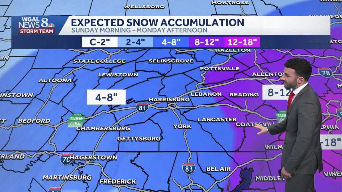
JOIN US TONIGHT AT 730 FOR THE OLYMPIC ZONE FINALE. NOW, THE WGAL NEWS EIGHT STORM TEAM FORECAST WITH METEOROLOGIST RYAN. ARCHANT. A STORM WARNING WILL BE GOING INTO EFFECT ONCE WE GET INTO OUR SUNDAY MORNING, LASTING UNTIL MONDAY AFTERNOON. FOR THE MAJORITY OF THE SUSQUEHANNA VALLEY. YOU CAN SEE HIGHLIGHTED IN PINK LANCASTER, LEBANON. DAUPHIN. YOU CAN SEE PERRY, CUMBERLAND AND YORK COUNTIES WILL BE UNDER THAT WINTER STORM WARNING BY THE TIME WE GET TO 5 A.M. SUNDAY. NOW WE’RE ALSO LOOKING AT A WINTER STORM WATCH, HOWEVER, FOR MIFFLIN, JUNIATA AND FRANKLIN COUNTIES FOR THAT SAME TIME PERIOD. BY THE WAY. 5 A.M. SUNDAY UNTIL 1 P.M. MONDAY. FOR AGAIN, THIS IS WHAT WE’RE WATCHING AS YOU GET INTO THE SECOND HALF OF THE WEEKEND. SO LET’S JUST GET RIGHT INTO IT. WE’RE GOING TO WE’RE GOING TO TRACK IT AS WE GO. SO HERE WE GO. 12 A.M. SUNDAY. WE’RE LOOKING AT THE BEGINNING OF THE STORM SYSTEM BEGINNING TO PUSH INTO THE SUSQUEHANNA VALLEY. SO IN THE NEXT SEVERAL HOURS, WE’RE GOING TO BE WATCHING. SO YOU CAN SEE IT REALLY STARTS OFF AS RAIN AND ALSO A LITTLE BIT OF A MIX. THIS IS SOMETHING ELSE WE’RE WATCHING. SO YOU CAN SEE A LITTLE BIT OF SOME SNOW MIXED IN WITH THAT. AND THEN ONCE WE GET INTO CLOSER TO 2 A.M. SUNDAY, YOU CAN SEE MAJORITY OF THIS IS RAIN. ALSO A LITTLE BIT OF A MIX TOWARDS OUR NORTHERN COMMUNITIES. THAT’S SOMETHING ELSE THAT WE’RE GOING TO BE WATCHING. SO REALLY EXPECTING A MIX BEGINNING TO DEVELOP HEADING INTO THE OVERNIGHT PERIOD FOR TONIGHT, GOING INTO THE REST OF THE MORNING, YOU SEE CLOSER TOWARDS 7 A.M. SUNDAY. SO A LOT OF FOLKS HAVE BEEN ASKING, HEY, WHAT CAN I EXPECT FOR SUNDAY MORNING SERVICES? AND WHAT SHOULD WE WHAT SHOULD WE PREPARE FOR? SO WE’RE REALLY LOOKING AT THIS MIX, PERSISTING THROUGH THE FIRST PART OF SUNDAY MORNING TO SEE MORE. SO RAIN FOR OUR SOUTHERN COMMUNITIES AND ALSO MORE SNOW. BUT THEN ONCE WE GET INTO LATER IN THE MORNING, INTO THE AFTERNOON, HERE WE GO. THIS IS WHEN WE’LL START TO SEE MORE OF THAT WIDESPREAD SNOW BEGIN TO DEVELOP IN SOME OF THOSE BRIGHTER PURPLES AND BRIGHTER WHITES FOR THE SUSQUEHANNA VALLEY. AND THEN THAT’S GOING TO PERSIST THROUGH THE AFTERNOON AND GETTING CLOSER TO THE EVENING. LOOK AT THE TIMESTAMP, BY THE WAY, 8:00 ON SUNDAY EVENING. THIS IS WHEN I EXPECT TO SEE THE HEAVIEST OF THE SNOW BEGINNING TO PUSH IN. YOU CAN SEE SOME OF THOSE BRIGHTER WHITES COMING IN OVER LANCASTER, LEBANON, DAUPHIN, YORK COUNTIES, FOR AN EXAMPLE. AND YOU CAN SEE THAT JUST SITS OVER THE SUSQUEHANNA VALLEY AS WE GET INTO SUNDAY NIGHT INTO MONDAY MORNING. NOW, IN TERMS OF IN TERMS OF SCHOOL, ALSO, WE ARE LOOKING AT THIS CHANCE OF SOME SNOW LINGERING, SOME OTHER MODELS RIGHT NOW ARE ARE ALLOWING THIS EVENT TO PERSIST A LITTLE BIT LONGER. BUT WE ARE EXPECTING THIS EVENT TO BE ENDING BY 12 P.M. ON MONDAY. YOU CAN SEE COULD SEE A LINGERING SNOW SHOWER OR TWO, A LIGHT SNOW SHOWER OR TWO FOR MONDAY AFTERNOON. BUT THE MAJORITY OF THIS, OR THE GUT OR THE MAJORITY OF THE STORM SYSTEM IS GOING TO HAVE HAVE MOVED OUT BY THE TIME WE GET TO MONDAY AFTERNOON. SO HERE’S WHAT WE’RE EXPECTING SUNDAY MORNING THROUGH MONDAY AFTERNOON. YOU CAN SEE 4 TO 8IN FOR THE REST. FOR THE MAJORITY OF THE SUSQUEHANNA VALLEY. NOW LOOKING TOWARDS OUR EASTERN COMMUNITIES, YOU CAN SEE 8 TO 12IN IS POSSIBLE FOR OUR FAR EASTERN COMMUNITIES. TOWARDS LANCASTER COUNTY. YOU CAN SEE THE MAJORITY ARE REALLY THE THE MAJORITY OF THE STORM SYSTEM IS GOING TO BE REMAINING TOWARDS THE JERSEY COAST LINE, ALSO TOWARDS THE PHILADELPHIA AREA WHERE THEY COULD BE SEEING BEYOND 12IN, MAYBE 12 TO 18IN OF SOME SNOW AS, AS A AS A POSSIBILITY. SO PARTLY CLOUDY CONDITIONS FOR THIS EVENING WITH CALM WINDS. ALTHOUGH THE CLOUDS WILL INCREASE LATE. WE’LL SEE THAT MIX DEVELOPING AS WELL ONCE WE GET INTO LATER TONIGHT. 30 TO 34 DEGREES. AND ONCE WE HEAD INTO TOMORROW, THAT SNOW BECOMES LIKELY. SOME OF THAT COULD BE IS GOING TO BE A MIX. BUT THEN THAT HEAVIEST OF THAT SNOW BEGINS TO MOVE IN LATER IN THE EVENING, WITH STEADY TEMPERATURES INTO THE LOWER TO MID 30S. NOW ALMANAC FOR THE DAY TODAY HIT A HIGH OF 48 DEGREES. 44 IS WHAT WE EXPECT FOR THIS TIME OF THE YEAR. AND THEN IN TERMS OF THE TEMPERATURES, WE’RE INTO THE 40S AT THIS TIME, 40 IN HARRISBURG, 44 IN LANCASTER, 43 IN YORK. SO THE SURFACE OF THE SURFACE RIGHT NOW ON THE GROUND IS QUITE MILD. SO IT’S WE’RE GOING TO BE EXPECTING WET TO SLUSHY CONDITIONS TO BEGIN FOR SUNDAY MORNING. AND THEN ONCE WE GET INTO LATER IN THE EVENING, THAT’S WHEN WE’LL START TO SEE MORE SNOW, SNOW COVERED ROADS. BUT IN TERMS OF WHERE THE STORM SYSTEM IS AT RIGHT NOW, DOWN TOWARDS THE SOUTH, DOWN TOWARDS ALABAMA AT THIS TIME, BUT IT’S GOING TO BE MOVING ITS WAY UP THE COAST CLOSER TOWARDS SUSQUEHANNA VALLEY. ONCE WE GET INTO OUR SUNDAY. NOW, SOMETHING ELSE I WANT TO POINT OUT, SOMETHING THAT WE’RE WATCHING AND WE’RE TRACKING. YOU SEE ALL THESE BRIGHTER WHITES. THERE’S A LOT OF RISING MOTION THAT’S HAPPENING. THERE’S A LOT OF SPREAD IN TERMS OF WHERE THAT RISING MOTION IS GOING TO BE PUT AT. AND IT LOOKS LIKE WE COULD BE SEEING SOME OF THOSE BRIGHTER WHITES IN THAT RISING MOTION, MOVING INTO PORTIONS OF, OF LANCASTER COUNTY. THAT’S SOMETHING THAT WE’RE GOING TO BE CONTINUING TO TRACK AND FINE TUNE, BUT WE ARE CONFIDENT THAT WE COULD BE SEEING THE HIGHEST OF THOSE TOTALS IN TERMS OF THE SUSQUEHANNA VALLEY, COULD BE SEEING THAT 8 TO 12 INCH THRESHOLD BE MET TOWARDS LANCASTER COUNTY, BUT YOU CAN SEE TEN DAY FORECAST ALERT DAY FOR SUNDAY FOR THAT SNOW. AND ALSO LINGERING INTO OUR MONDAY MORNING LOOKING AHEAD INTO THE REST OF THE WORKWEEK, THERE IS A CHANCE OF A CLIPPER SYSTEM THAT WILL COME THROUGH FOR WEDNESDAY MORNING. SO WE DO HAVE A CHANCE OF SOME
ALERT: Light to heavy snow mix for Sunday across south-central Pennsylvania
A Winter Storm Warning is in effect for parts of the majority of the Valley. A winter storm is expected to bring accumulating snow to the Susquehanna Valley beginning Sunday morning and continuing through Sunday night.

Updated: 6:31 PM EST Feb 21, 2026
A Winter Storm Warning has been issued by the National Weather Service for Adams, Cumberland, Dauphin, Lancaster, Lebanon, and York counties from 5 AM Sunday until 1 PM Monday.A Winter Storm Watch has been issued by the National Weather Service for Mifflin, Juniata, and Franklin counties from 5 AM Sunday until 1 PM Monday.ALERT SUNDAY INTO EARLY MONDAY:Low pressure will move off the coast of North Carolina and Virginia early Sunday. Expect light snow to develop in the Susquehanna Valley after midnight tonight through early Sunday afternoon. The snow may mix with rain or sleet at times. Surface temperatures will be above freezing during the day, so roads will likely be wet to slushy. Once the sun sets, we’ll see mainly snow.The chance of snow continues Sunday night into early Monday. Overnight, roads may be slushy to snowy. The majority of the Susquehanna Valley can expect 4-8″ of snow with the highest totals south & east of I-81. A few locations may pick up more than 8″ in York and Lancaster counties.NEXT WEEK:Colder temperatures in the low-to-mid 30s are in store on Monday and Tuesday. Add a blustery breeze, and it will feel like the 20s.Temperatures moderate to the low 40s on Wednesday, and rain chances increase from late Wednesday into Thursday. Highs will reach the mid-40s on Thursday.Slightly cooler temperatures are in store for Friday, then the following weekend looks dry and pleasant, with highs in the mid-40s.
A Winter Storm Warning has been issued by the National Weather Service for Adams, Cumberland, Dauphin, Lancaster, Lebanon, and York counties from 5 AM Sunday until 1 PM Monday.
A Winter Storm Watch has been issued by the National Weather Service for Mifflin, Juniata, and Franklin counties from 5 AM Sunday until 1 PM Monday.
ALERT SUNDAY INTO EARLY MONDAY:
Low pressure will move off the coast of North Carolina and Virginia early Sunday. Expect light snow to develop in the Susquehanna Valley after midnight tonight through early Sunday afternoon. The snow may mix with rain or sleet at times. Surface temperatures will be above freezing during the day, so roads will likely be wet to slushy. Once the sun sets, we’ll see mainly snow.
The chance of snow continues Sunday night into early Monday. Overnight, roads may be slushy to snowy. The majority of the Susquehanna Valley can expect 4-8″ of snow with the highest totals south & east of I-81. A few locations may pick up more than 8″ in York and Lancaster counties.
NEXT WEEK:
Colder temperatures in the low-to-mid 30s are in store on Monday and Tuesday. Add a blustery breeze, and it will feel like the 20s.
Temperatures moderate to the low 40s on Wednesday, and rain chances increase from late Wednesday into Thursday. Highs will reach the mid-40s on Thursday.
Slightly cooler temperatures are in store for Friday, then the following weekend looks dry and pleasant, with highs in the mid-40s.