
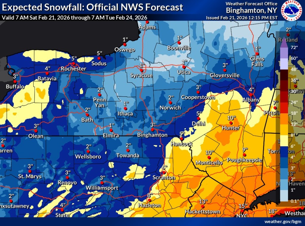
A winter storm watch is in effect for Northeastern Pennsylvania, with forecasters predicting 4 to 12 inches of snow to fall in the region Sunday into Monday, and accumulations on the lower end locally.
Meteorologists with the National Weather Service expect southern areas such as Pottsville and Hazleton to be hit first and receive higher accumulations of snow than residents in the Wilkes-Barre and Scranton areas, as a nor’easter moves northeast along the Mid-Atlantic Coast.
The storm watch from the NWS office in State College, in effect from 5 a.m. Sunday through 1 p.m. Monday, calls for total snow accumulations between 5 and 10 inches in Schuylkill and more southern counties, with winds that could gust as high as 35 mph Sunday night and Monday.
But, a detailed forecast for Pottsville released Saturday morning calls for lesser snow accumulations. Snow was expected to begin falling there after 3 a.m. Sunday, with heavier snow developing after 7 a.m., producing accumulations from 1 to 3 inches during the day and another 3 to 5 inches overnight. Sunday’s high should be around 33 degrees, and Monday’s should be around 35.
The storm watch issued for Lackawanna, Luzerne and Wyoming counties, which remains in effect from 7 a.m. Sunday through 7 p.m. Monday, predicts total snow accumulations between 6 and 12 inches, and winds gust as high as 35 mph, according to the NWS office in Binghamton, New York.
The Scranton, Wilkes-Barre and Hazleton areas should receive accumulations on the lower end, according to detailed forecasts.
In the Scranton area, snow was expected to begin after 3 a.m. Sunday, possibly mixed with rain throughout the day until becoming all snow after 1 p.m., with little or no accumulation expected. Snowfall Sunday night could produce accumulations of about 4 inches. Sunday’s high temperature should be around 38 degrees, with low-speed winds, while Monday’s high will be near 35, with 13- to 20-mph winds.
In the Wilkes-Barre area, rain was expected before 3 a.m. Sunday, then turn to snow, followed by a mix of snow and rain, with little accumulation expected. Rain should stop around 4 p.m., with just snow falling late Sunday afternoon and evening and an expected accumulation of around 3 inches. Sunday’s high will be around 38 degrees, while Monday’s will be near 35, with wind gusts as high as 26 mph.
In the Hazleton area, forecasters expect snow to begin falling around 2 a.m. Sunday, with about 2 inches accumulating throughout the day and another 4 inches overnight. Sunday’s high will be around 34, but wind gusts could reach 20 mph. Monday’s high will be around 32, with wind gusts as high as 34 mph.
There’s a chance the snow could continue falling in all four areas until around 1 p.m. Monday.
The weather service warns that travel could be difficult, with hazardous conditions especially affecting Monday morning and evening commutes.