
Impact Day: Light snow for Pittsburgh, winter weather alerts east
The Laurel Highlands are under a Winter Weather Advisory or Winter Storm Warning until 1 a.m. Tuesday.
WILL GET NEW ROUTING AND SCHEDULES STARTING TODAY. IN THE MEANTIME, LET’S GET YOU A CHECK OF YOUR CERTIFIED MOST ACCURATE FORECAST ON THIS IMPACT DAY. JILL’S BACK. THE SNOW IS BEAUTIFUL OUT THERE, BUT NOT NECESSARILY THE BEST SIGHT TO SEE. NOT THAT WHAT WE WANT TO SEE AFTER WE MELTED DOWN ALL THAT STUFF THAT WE GOT LAST MONTH. IT FINALLY THIS WEEK. BUT STILL IT LOOKS REALLY PRETTY OUT THERE AS THAT SNOW IS CLINGING TO EVERYTHING BUT THE ROADS AND PROBABLY GOING TO SEE LESS OF AN IMPACT ON TRAVEL BECAUSE WE HAVE SUCH WARM GROUND TEMPERATURES. BUT STILL, THINGS ARE A LITTLE BIT WET OUT THERE THIS MORNING. SO WHAT’S IN STORE FOR THIS IMPACT DAY? WE HAVE LIGHT SNOW THAT’S COMING IN. IT WILL BE STEADIER, ESPECIALLY INTO THE LAUREL HIGHLANDS, WHERE YOUR ACCUMULATIONS COULD RANGE ANYWHERE FROM 2 TO 5IN OF SNOW. MEANWHILE, THE MAJORITY OF US REALLY WANT TO HONE IN ON THAT. THE MAJORITY OF US WILL ONLY SEE ABOUT 1 TO 2IN BETWEEN TODAY AND TOMORROW. THE INITIAL ONSET OF THE SNOW COMING IN SHORTLY AFTER MIDNIGHT, STILL SEEING SOME STEADIER BURSTS OF ACTIVITY AS WE HEAD INTO EASTERN PARTS OF ALLEGHENY COUNTY. AS WE LOOK FROM ELIZABETH TOWNSHIP UP TOWARDS MCKEESPORT PENN HILLS SPILLING OVER TOWARDS MONROEVILLE, MURRYSVILLE, EVEN UP TOWARDS APOLLO IN THE KISKI AREA, SOUTHERN PARTS OF ARMSTRONG COUNTY, TRAVELING ALONG 422. A LOT OF FLAKES HITTING YOUR WINDSHIELD THIS MORNING OR YOUR WINDOWS ARE GETTING THE DAY STARTED AS SNOW IS A LITTLE BIT STEADIER THERE. BUT WIDENING OUT THE VIEW YOU CAN SEE FROM WASHINGTON POINTS SOUTH AND WEST, THE SNOW IS SLOWING DOWN. IT DOESN’T MEAN WE’RE OUT OF THE WOODS COMPLETELY. WE WILL SEE MORE SNOW DEVELOPING AS WE WORK INTO THE AFTERNOON. ALL OF OUR COUNTIES EAST UNDER SOME SORT OF WINTER WEATHER ALERT, WHETHER IT BE A WINTER WEATHER ADVISORY FROM INDIANA TO GREENSBURG, UNIONTOWN AND MORGANTOWN AREA SHADED IN PINK. THAT’S THE HIGHER ELEVATIONS. WINTER STORM WARNING. AND THAT’S WHERE WE ARE ANTICIPATING THE HIGHEST, MOST SUBSTANTIAL ACCUMULATION FROM THIS STORM. IN FACT, SOME AREAS LIKE SEVEN SPRINGS, WE COULD BE WALLOPING CLOSE TO A FOOT OF SNOW BEFORE THINGS ARE ALL SAID AND DONE BY MONDAY. SO TODAY IS AN IMPACT DAY IN YOUR FOUR DAY FORECAST, WE’LL SEE MORE SCATTERED SNOW, ESPECIALLY DURING THE FIRST HALF OF THE DAY. MONDAY STAYS CHILLY THROUGH TUESDAY WITH A HIGH ONLY NEAR FREEZING. THEN WE HAVE BACK TO BACK QUICK SYSTEMS. WE’LL BRING THE OPPORTUNITY FOR SOME WET SNOWFLAKES CHANGING OVER TO RAIN FIRST ROUND, BEGINNING HERE ON WEDNESDAY FOR THE TIME BEING. AGAIN, KEEPING AN EYE ON ABOUT 1 TO 2IN FOR MOST OF THE AREA. THOSE AREAS SHADED IN BLUE COULD SEE ANYWHERE FROM 2 TO 5IN. ONCE THE STORM IS ALL SAID AND DONE, HOW WILL THE SNOW ACCUMULATE? WELL, DURING THE DAY TODAY? NOT EXPECTING A WHOLE LOT, MAYBE UNDER AN INCH IN MOST SPOTS WITH THE EXCEPTION OF THE LAUREL HIGHLANDS, SNOW IS GOING TO STAY STEADY, ESPECIALLY OUT EAST, AS WE GO THROUGH THE OVERNIGHT AND INTO THE DAY TOMORROW. AND THAT’S WHERE WE REALLY START TO SEE THOSE ACCUMULATIONS RAMPING UP AGAIN. MOST OF THE AREA STAYING UNDER TWO INCHES OF SNOW AS AS YOU START TO CLIMB IN ELEVATION, THOSE TOTALS WILL BE RAMPING UP. YOU CAN SEE AROUND SOMERSET ABOUT 8.5IN OF SNOW. ONCE THINGS ARE ALL SAID AND DONE LATE TOMORROW, LET’S TALK ABOUT THE TIMING AND YOU CAN SEE THAT LITTLE BIT OF A LULL ON IN FUTURECAST AS WE ROLL THROUGH THE SECOND HALF OF THE MORNING. MORE SNOW FILLS IN, ESPECIALLY INTO THE LAURELS. STILL RATHER SCATTERED SNOW SHOWERS INTO THE SECOND HALF OF THE DAY. THAT’S PROBABLY WHEN WE GET MOST OF OUR LIGHT ACCUMULATION AREA WIDE. WE’LL SEE THAT ADDITIONAL SNOW LASTING THROUGH THE EARLY MORNING HOURS. WE COULD SEE SOME DIFFICULT TRAVEL, ESPECIALLY ALONG THE TURNPIKE HEADING OUT EAST TOMORROW MORNING. EVERYBODY ELSE, JUST SOME WET ROADS WITH EVERYTHING REALLY STARTING TO BREAK DOWN AS WE GET CLOSER TO NOONTIME TOMORROW. AGAIN, THAT CHILL LASTS THROUGH TUESDAY. THEN WE SEE A QUICK ROUND OF SOME WET SNOW ARRIVING LATE TUESDAY NIGHT, SPILLING OVER INTO WEDNESDAY, ENDING AS RAIN THURSDAY POSES POTENTIALLY AN IMPACT DAY FOR US AS WE’LL CONTINUE TO MONITOR THE TIMING OF THAT SYSTEM. LOOKS TO BE COMING IN A LITTLE BIT SOONER, SO THAT COULD USHER IN THE POSSIBILITY OF A FEW MORE WET SNOWFLAKES ON THURSDAY, TEMPERATURES KIND OF BOUNCING AROUND 40S, 50S, EVEN THE UPPER 30S. AS WE GET GOING INTO THE FIRST DAY OF MARCH NEXT SUNDAY. IT’S ALSO THE FIRST DAY
Impact Day: Light snow for Pittsburgh, winter weather alerts east
The Laurel Highlands are under a Winter Weather Advisory or Winter Storm Warning until 1 a.m. Tuesday.

Updated: 6:15 AM EST Feb 22, 2026
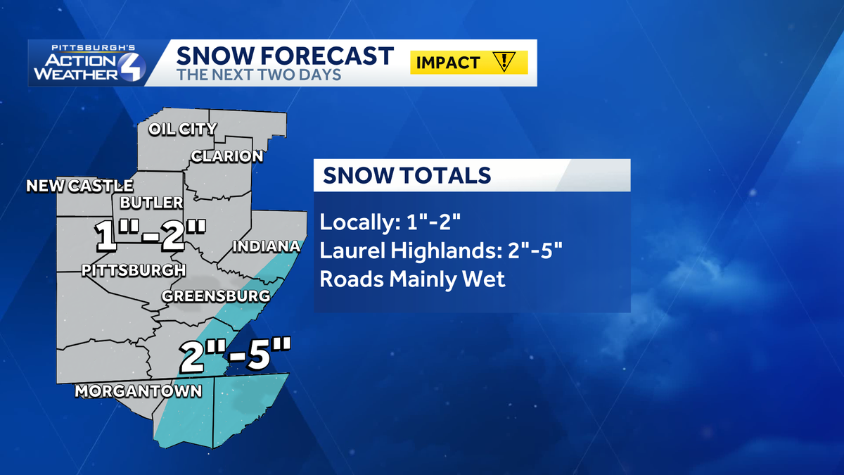
Today is an Impact Day for a “nuisance” light snow. The majority of western Pennsylvania will pick up one to two inches of snow by late Monday. Roads won’t be impacted and just stay wet. Meanwhile, in the Laurel Highlands the snow will be heavier and steadier with some areas picking up close to half a foot.Impact Day for snowWe are on the fringe of significant winter storm for the East Coast. Blizzard Warnings are posted for a number of the major cities. Impacts will be minimal for most of the area. The Laurel Highlands will be hit harder with a more sustainable snowfall. More snow will fill in this afternoon. Activity will become more scattered again overnight, with ongoing steady snow in the Laurels. The snow will finally shut off around mid-day Monday.For Pittsburgh and the surrounding area, we are expecting one to two inches of snow by late Monday. The snow will have a hard time sticking to the pavement due to warm ground temperatures and above freezing air temperatures. To the east – accumulations will increase with elevation. Two to five inches are possible with higher amounts for western Somerset County.Winter weather alertsWinter weather alerts are now in effect for our counties east and into northern West Virginia and western Maryland through 1 a.m. Tuesday.Eastern Fayette, Indiana and Westmoreland along with Garrett, Preston and the higher spots of Monongalia counties are under a Winter Storm Warning.A Winter Weather Advisory is posted for the rest of Fayette, Indiana, Westmoreland and Monongalia counties.Chilly start to the new weekTemperatures are parked in the 30s to begin next week. The chill is temporary with highs trending more seasonal in the mid 40s by mid-week.We are tracking back-to-back fast moving systems that will bring periods of rain and non-accumulating wet snow. The first arrives Tuesday night with wet flakes ending as rain. Thursday’s clipper will primarily feature chilly rain showers and potential for snow to the north.TODAY – Impact Day: Light snow; steadier for the Laurel Highlands. High: 37°.TONIGHT: Scattered snow showers. Low: 29°.MONDAY: Scattered morning snow showers, breezy. High: 34°, low: 19°.TUESDAY: Mostly cloudy and chilly. Snow showers north arrive late. High: 32°, low: 28°.WEDNESDAY: Wet snow and rain showers end. High: 45°, low: 33°.
PITTSBURGH —
Today is an Impact Day for a “nuisance” light snow. The majority of western Pennsylvania will pick up one to two inches of snow by late Monday. Roads won’t be impacted and just stay wet. Meanwhile, in the Laurel Highlands the snow will be heavier and steadier with some areas picking up close to half a foot.
Impact Day for snow
We are on the fringe of significant winter storm for the East Coast. Blizzard Warnings are posted for a number of the major cities. Impacts will be minimal for most of the area. The Laurel Highlands will be hit harder with a more sustainable snowfall.
More snow will fill in this afternoon. Activity will become more scattered again overnight, with ongoing steady snow in the Laurels. The snow will finally shut off around mid-day Monday.

Hearst OwnedHearst
This afternoon will feature the best coverage of snow.
For Pittsburgh and the surrounding area, we are expecting one to two inches of snow by late Monday. The snow will have a hard time sticking to the pavement due to warm ground temperatures and above freezing air temperatures. To the east – accumulations will increase with elevation. Two to five inches are possible with higher amounts for western Somerset County.

Hearst OwnedHearst
A light snow event with minimal impacts on the roads for the Pittsburgh areas. The Laurel Highlands will see more significant accumulations especially for the highest elevations.
Winter weather alerts
Winter weather alerts are now in effect for our counties east and into northern West Virginia and western Maryland through 1 a.m. Tuesday.

Hearst OwnedHearst
Winter weather alerts are in effect until 1 a.m. Tuesday for counties to the east.
Eastern Fayette, Indiana and Westmoreland along with Garrett, Preston and the higher spots of Monongalia counties are under a Winter Storm Warning.
A Winter Weather Advisory is posted for the rest of Fayette, Indiana, Westmoreland and Monongalia counties.
Chilly start to the new week
Temperatures are parked in the 30s to begin next week. The chill is temporary with highs trending more seasonal in the mid 40s by mid-week.
We are tracking back-to-back fast moving systems that will bring periods of rain and non-accumulating wet snow. The first arrives Tuesday night with wet flakes ending as rain. Thursday’s clipper will primarily feature chilly rain showers and potential for snow to the north.

Hearst OwnedHearst
Back-to-back quick systems will bring periods of wet snow and rain on Wednesday and Thursday.
TODAY – Impact Day: Light snow; steadier for the Laurel Highlands. High: 37°.
TONIGHT: Scattered snow showers. Low: 29°.
MONDAY: Scattered morning snow showers, breezy. High: 34°, low: 19°.
TUESDAY: Mostly cloudy and chilly. Snow showers north arrive late. High: 32°, low: 28°.
WEDNESDAY: Wet snow and rain showers end. High: 45°, low: 33°.