
Today is an Impact Day for “nuisance” light snow. The majority of western Pennsylvania will pick up one to two inches of snow by late Monday. Roads won’t be impacted and just stay wet. Meanwhile, in the Laurel Highlands the snow will be heavier and steadier with some areas picking up close to half a foot.Winter weather alertsWinter weather alerts are now in effect for our counties east and into northern West Virginia and western Maryland through 1 a.m. Tuesday.A Winter Storm Warning for eastern Fayette, Indiana and Westmoreland along with Garrett, Preston, Tucker and the higher spots of Monongalia counties.A Winter Weather Advisory is posted for the rest of Fayette, Indiana, Westmoreland and Monongalia counties.Impact Day for snowWe are on the fringe of significant winter storm for the East Coast. Blizzard Warnings are posted for a number of the major cities. Impacts will be minimal for most of the area. The Laurel Highlands will be hit harder with a more sustainable snowfall.More snow will fill in this afternoon. Activity will become more scattered again overnight, with ongoing steady snow in the Laurels. The snow will finally shut off around mid-day Monday.For Pittsburgh and the surrounding area, we are expecting one to two inches of snow by late Monday. The snow will have a hard time sticking to the pavement due to warm ground temperatures and above freezing air temperatures. To the east – accumulations will increase with elevation. Two to five inches are possible with higher amounts for western Somerset County.A chilly start to the weekTemperatures are parked in the 30s to begin next week. The chill is temporary with highs trending more seasonal in the mid 40s by mid-week.We are tracking back-to-back fast moving systems that will bring periods of rain and non-accumulating wet snow. The first arrives Tuesday night with wet flakes ending as rain. Thursday’s clipper will primarily feature chilly rain showers and potential for snow to the north.TODAY – Impact Day: Light snow; steadier for the Laurel Highlands. High: 37°.TONIGHT: Scattered snow showers. Low: 29°.MONDAY: Scattered morning snow showers, breezy. High: 34°, low: 19°.TUESDAY: Mostly cloudy and chilly. Snow showers north arrive late. High: 32°, low: 28°.WEDNESDAY: Wet snow and rain showers end. High: 45°, low: 33°.
PITTSBURGH —
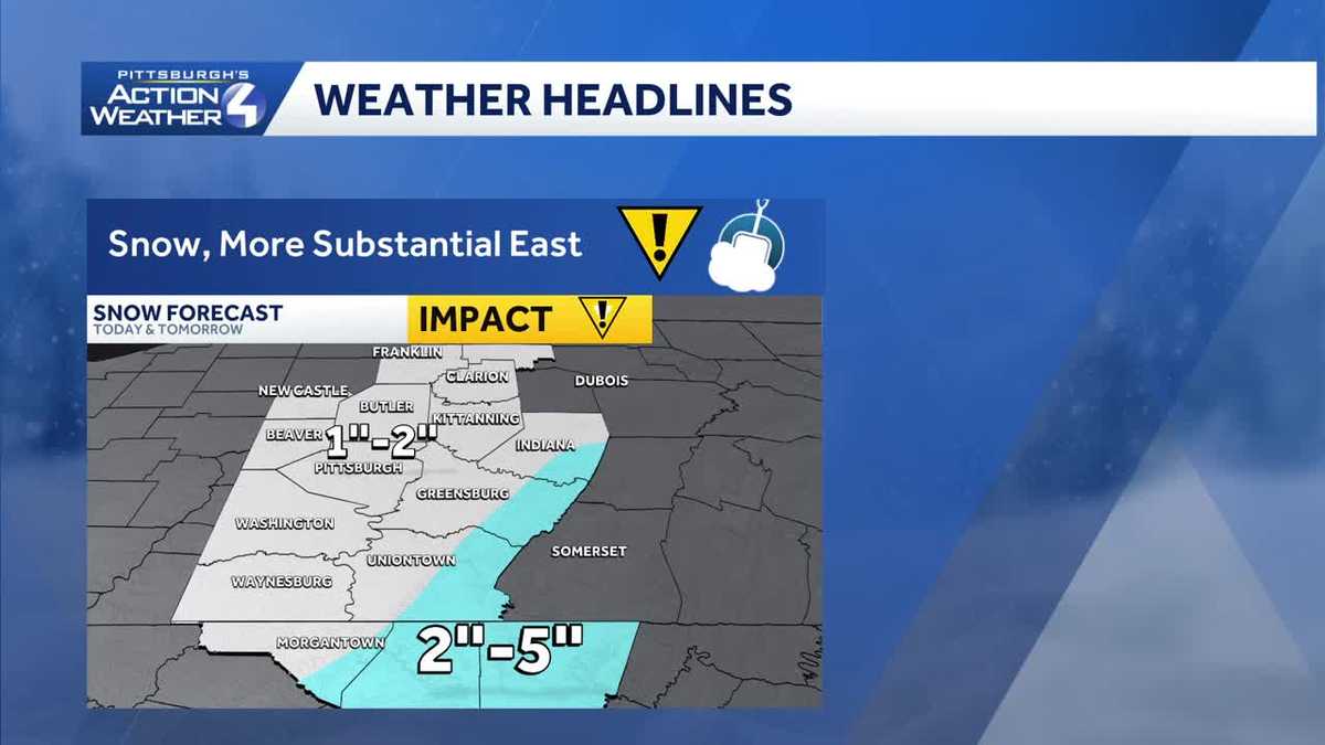
Today is an Impact Day for “nuisance” light snow. The majority of western Pennsylvania will pick up one to two inches of snow by late Monday. Roads won’t be impacted and just stay wet. Meanwhile, in the Laurel Highlands the snow will be heavier and steadier with some areas picking up close to half a foot.
Winter weather alerts
Winter weather alerts are now in effect for our counties east and into northern West Virginia and western Maryland through 1 a.m. Tuesday.

Hearst OwnedHearst
Winter weather alerts for Fayette, Indiana, Westmoreland, Monongalia, Preston, Tucker and Garrett counties.
A Winter Storm Warning for eastern Fayette, Indiana and Westmoreland along with Garrett, Preston, Tucker and the higher spots of Monongalia counties.
A Winter Weather Advisory is posted for the rest of Fayette, Indiana, Westmoreland and Monongalia counties.
Impact Day for snow
We are on the fringe of significant winter storm for the East Coast. Blizzard Warnings are posted for a number of the major cities. Impacts will be minimal for most of the area. The Laurel Highlands will be hit harder with a more sustainable snowfall.
More snow will fill in this afternoon. Activity will become more scattered again overnight, with ongoing steady snow in the Laurels. The snow will finally shut off around mid-day Monday.

Hearst OwnedHearst
The bulk of our accumulation arrives Sunday afternoon.
For Pittsburgh and the surrounding area, we are expecting one to two inches of snow by late Monday. The snow will have a hard time sticking to the pavement due to warm ground temperatures and above freezing air temperatures. To the east – accumulations will increase with elevation. Two to five inches are possible with higher amounts for western Somerset County.

Hearst OwnedHearst
Higher snow totals for the Laurel Highlands. Only one to two inches are the rest of the area.
A chilly start to the week
Temperatures are parked in the 30s to begin next week. The chill is temporary with highs trending more seasonal in the mid 40s by mid-week.
We are tracking back-to-back fast moving systems that will bring periods of rain and non-accumulating wet snow. The first arrives Tuesday night with wet flakes ending as rain. Thursday’s clipper will primarily feature chilly rain showers and potential for snow to the north.

Hearst OwnedHearst
We are monitoring back-to-back clippers for wet snow and rain on Wednesday and Thursday.
TODAY – Impact Day: Light snow; steadier for the Laurel Highlands. High: 37°.
TONIGHT: Scattered snow showers. Low: 29°.
MONDAY: Scattered morning snow showers, breezy. High: 34°, low: 19°.
TUESDAY: Mostly cloudy and chilly. Snow showers north arrive late. High: 32°, low: 28°.
WEDNESDAY: Wet snow and rain showers end. High: 45°, low: 33°.