
The National Weather Service is warning of a “potentially historic winter storm” that will dump up to 18 inches of snow on the Lehigh Valley starting Sunday afternoon. A blizzard warning has been extended to the southern Poconos, where up to two feet of snow is possible.
The Lehigh Valley is under a winter storm warning through 6 p.m. Monday.
Projected snow totals for the storm increased again Sunday morning. The Lehigh Valley is expected to see 12 to 18 inches of snow, according to the National Weather Service forecast office in Mount Holly, New Jersey. To our south, the greater Philadelphia region, including Bucks and Montgomery counties, are expected to get between 18 and 24 inches.
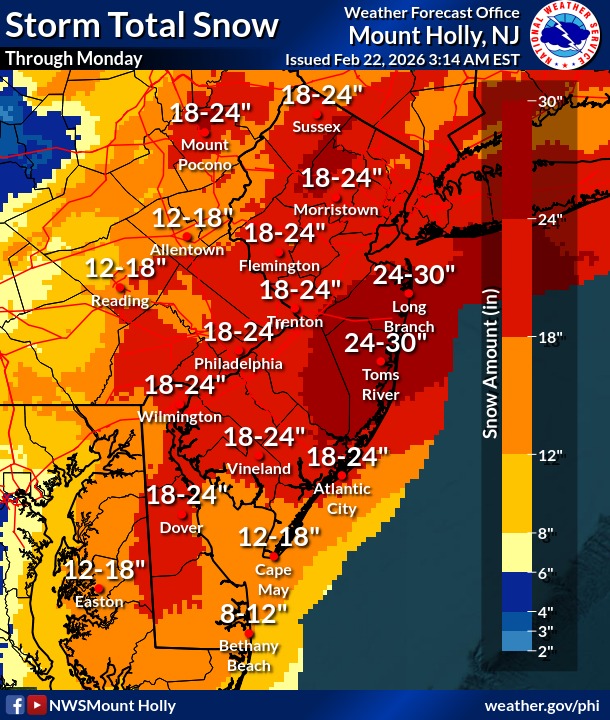 The latest snowfall projections from the National Weather Service in Mount Holly, New Jersey.
A blizzard warning has been extended to include all of Bucks County and parts of southern Montgomery County, along with all of New Jersey and Delaware. A blizzard warning is issued when a storm has sustained wind or frequent wind gusts of 35 mph or greater, combined with considerable falling and/or blowing snow that can reduce visibility to less than a quarter mile.
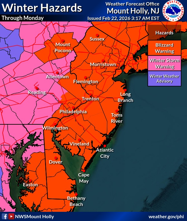 The National Weather Service has extended its blizzard warning to include parts of the Poconos.
Many Lehigh Valley municipalities already have declared snow emergencies ahead of the storm, and PennDOT has announced road restrictions starting at 3 p.m.
There remain some discrepancies in forecast models, the weather service said, and “western fringe” areas of the region could see reduced snowfall totals. However, “warning level snow is still expected everywhere,” forecasters said.
Snow is expected to begin falling before dawn Sunday morning. Some areas near and south of Interstate 78 could see rain in the beginning thanks to milder Sunday morning temperatures in the mid-30s, the weather service said. There’s even a possibility of some freezing rain mixing in.
Colder air will begin to infiltrate the area this afternoon, and the precipitation will change to snow fairly quickly. Snowfall rates could exceed 2 inches per hour. The heaviest snowfall and strongest winds are expected to start this evening and last through the night, tapering off Monday morning. Snow will come to an end from west to east Monday afternoon.
Snow covered roads along with reduced visibility from blowing snow will make travel difficult if not impossible. The hazardous conditions will impact the Monday morning commute, and possibly the Monday evening commute in some areas, forecasters said.
The storm also will bring high winds, with gusts up to 45 mph possible in the Lehigh Valley and Poconos. Wind could lead to downed trees and power outages, the weather service warns.
The weather is expected to remain unsettled into next week, with wind gusts lasting into Tuesday and possible light snow or a wintry mix Tuesday night into Wednesday.
This is a developing story. Check back for updates.