
A potentially historic winter storm will impact the Lehigh Valley and northeastern Pennsylvania through Monday, bringing very heavy, crippling snowfall and areas of blizzard conditions.
The National Weather Service has issued blizzard warnings for the region, with the most significant impacts expected Sunday evening through Monday morning.
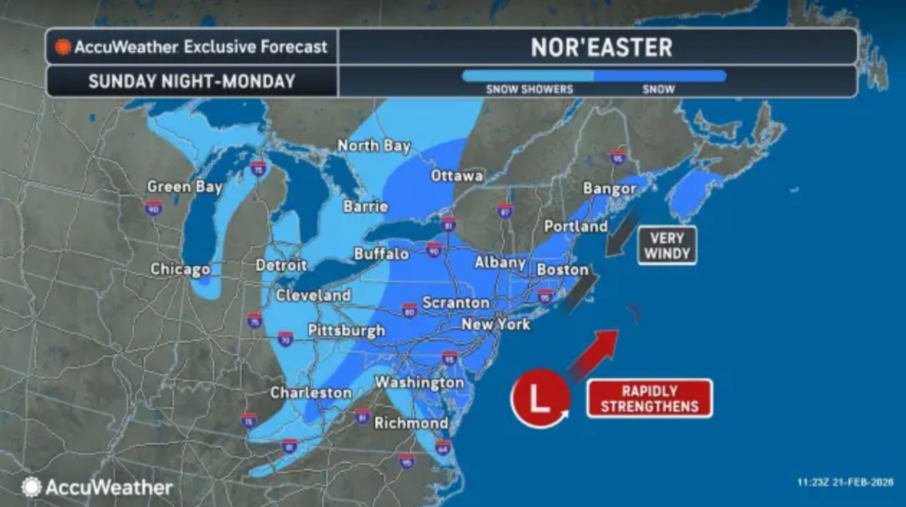
Light precipitation began to move into the area Sunday morning from the southwest. As a potent low-pressure system approaches from the Carolinas and tracks off the Mid-Atlantic Coast, precipitation will increase significantly through the afternoon.
Temperatures will remain mild enough near and south of the Interstate 78 corridor through midday for precipitation to fall as rain or a rain-snow mix, but a transition to all snow is expected this afternoon and evening as colder air moves in.
Snowfall rates could exceed two inches per hour where the heaviest accumulations are forecast. For the Lehigh Valley and eastern Pennsylvania, widespread snowfall accumulations of one to two feet are expected.
The heaviest snow and strongest winds are anticipated between Sunday evening through Monday morning, with snow tapering off from west to east Monday afternoon.
Northeast winds will increase to 20 to 35 mph with gusts of 35 to 45 mph inland. Blowing and drifting snow will create life-threatening travel conditions, and scattered power outages are possible.
The National Weather Service strongly recommends avoiding travel during the height of the storm.
A blizzard warning remains in effect for the southern Poconos and adjacent areas from 10 a.m. Sunday through 6 p.m. Monday. All 21 New Jersey counties are also under a blizzard warning.
Winter storm warnings are in effect for the remainder of the area, including Lehigh and Northampton counties.
Confidence remains very high in major to extreme impacts across the region, regardless of exact snowfall amounts.Following the storm, conditions will remain unsettled through mid-to-late week.
A brief area of high pressure will bring drier conditions Monday night into Tuesday, though gusty northwest winds of 20 to 30 mph with localized gusts to 35 to 45 mph in the Poconos are expected Monday night.
The next system arrives Tuesday night into Wednesday morning with chances for light snow and rain, particularly north and west of Interstate 95.
Additional precipitation is possible Thursday night, with heavier rainfall potentially causing some melting of the deep snow pack from the weekend storm, though flooding concerns remain low at this time.