
Moderate to heavy snow expected Sunday into Monday | Latest track, totals

Updated: 1:27 PM EST Feb 22, 2026
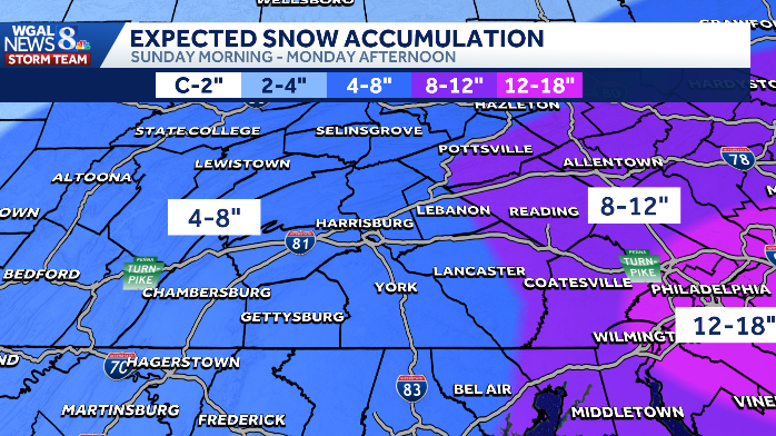
A winter storm will bring moderate to heavy snow and gusty winds to South-Central Pennsylvania Sunday into Monday.The WGAL News 8 Storm Team has declared Sunday and Monday Alert Days, meaning the days could feature the threat of extreme, severe and possibly life-threatening weather.A winter storm warning is in effect for the entire Susquehanna Valley until Monday at 1 p.m. Pennsylvania Gov. Josh Shapiro declared a disaster emergency ahead of the storm, effective immediately. What to expect Sunday Light snow through the day with some mixed precipitation possible.Early accumulations will be slow because road surfaces are still mild; expect wet to slushy roads.Snow intensity increases Sunday evening, becoming moderate to heavy at times and continuing overnight.Snow accumulations, timing Sunday night into Monday morning: most of the Susquehanna Valley will see 4 to 8 inches of snow.Heaviest totals (parts of Lancaster, Lebanon, York counties): 8 to 12 inches of snow are possible by the end of the storm. Snow may linger in far eastern areas until around noon Monday. Winds and impacts Sunday night: Winds increase to 10–20 mph with gusts of 30–35 mph as low pressure deepens off the coast. Monday: Northwest winds 15–25 mph with gusts near 40 mph; gusty conditions persist into Tuesday.Impacts: Reduced visibility, blowing/drifting snow, possible downed branches and power interruptions.Travel and safety Expect hazardous travel conditions—wet/slushy roads Sunday afternoon, quickly turning snow-covered tonight.Avoid nonessential travel during the overnight period and Monday morning if possible.Prepare emergency supplies, allow extra travel time, and monitor local forecasts for updates.Temperatures and wind chillSunday highs: Mid 30s. Monday highs: Low 30s; wind chills in the 20s. SOUTH-CENTRAL PA WEATHER RESOURCES: INTERACTIVE RADAR | ACTIVE WEATHER ALERTS | CURRENT CONDITIONS | HOURLY FORECAST | 10-DAY FORECAST | WEEKEND FORECAST | MAP ROOM | DOWNLOAD THE APP | WEATHER EMAILS
A winter storm will bring moderate to heavy snow and gusty winds to South-Central Pennsylvania Sunday into Monday.
The WGAL News 8 Storm Team has declared Sunday and Monday Alert Days, meaning the days could feature the threat of extreme, severe and possibly life-threatening weather.
A winter storm warning is in effect for the entire Susquehanna Valley until Monday at 1 p.m.

Pennsylvania Gov. Josh Shapiro declared a disaster emergency ahead of the storm, effective immediately.
What to expect Sunday
Light snow through the day with some mixed precipitation possible.Early accumulations will be slow because road surfaces are still mild; expect wet to slushy roads.Snow intensity increases Sunday evening, becoming moderate to heavy at times and continuing overnight.

Snow accumulations, timing Sunday night into Monday morning: most of the Susquehanna Valley will see 4 to 8 inches of snow.Heaviest totals (parts of Lancaster, Lebanon, York counties): 8 to 12 inches of snow are possible by the end of the storm. Snow may linger in far eastern areas until around noon Monday.

Winds and impacts Sunday night: Winds increase to 10–20 mph with gusts of 30–35 mph as low pressure deepens off the coast. Monday: Northwest winds 15–25 mph with gusts near 40 mph; gusty conditions persist into Tuesday.Impacts: Reduced visibility, blowing/drifting snow, possible downed branches and power interruptions.

Travel and safety Expect hazardous travel conditions—wet/slushy roads Sunday afternoon, quickly turning snow-covered tonight.Avoid nonessential travel during the overnight period and Monday morning if possible.Prepare emergency supplies, allow extra travel time, and monitor local forecasts for updates.

Temperatures and wind chillSunday highs: Mid 30s. Monday highs: Low 30s; wind chills in the 20s.


SOUTH-CENTRAL PA WEATHER RESOURCES: INTERACTIVE RADAR | ACTIVE WEATHER ALERTS | CURRENT CONDITIONS | HOURLY FORECAST | 10-DAY FORECAST | WEEKEND FORECAST | MAP ROOM | DOWNLOAD THE APP | WEATHER EMAILS