
It wouldn’t be a weekend this winter season without a winter storm, especially on a Sunday. This weekend is definitely no exception.
This impending storm has certainly been a headache to forecast and there are still some uncertainties as to how much snow we can squeeze out. But, there is no question that this will be a very impactful Nor’Easter for a lot of the Mid-Atlantic and Northeast.

Maxuser
WHAT WE KNOW
Nor’easter definite: A coastal storm will rapidly strengthen later this evening and tonight, and lift northeast off the Mid-Atlantic coast. This will be a powerful Nor’easter, with blizzard conditions along the shore and a widespread accumulating snow for the Northeast Corridor.
Maxuser
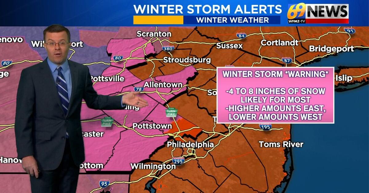
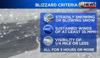
The coast and much of New Jersey will get the most: Blizzard warnings remain in effect for the southern Poconos, Delaware Valley, Long Island, and the entire state of New Jersey and Delaware. These areas will see heavy snow, 50+ mph gusts, and whiteout conditions at times later tonight, in addition to easily a foot or more of snow in most cases. Keep in mind, the true definition of a blizzard does not involve snowfall amounts. You must have winds sustained or frequent gusts of 35mph or greater, visibility ¼ mile or less due to falling or blowing snow, and all of this must be met for at least 3 hours.
Maxuser
Timing and Precipitation Type: Most of the region so far has been experiencing either some light snow, a light rain/snow mix, or just plain old light rain south of I-78. As the precipitation intensity starts to increase later this afternoon, surfaces temperatures will drop closer to 32 degrees and we can expect any rain or mix to change over to all snow from north to south. The steadiest and heaviest snow is then expected to fall from the evening, through the overnight hours, and then into first thing Monday morning.
Winds: Increasingly brisk easterly, then northeasterly, and then finally northerly winds are expected as our Nor’easter cranks up off the coast. Winds will be strongest at the shore, where 50-55mph gusts are expected. Farther inland, winds still have the potential to gust at 30-40mph. Blowing and drifting of snow will be possible later tonight into Monday.

Maxuser
Warnings: Winter storm warnings are in effect for much of eastern Pennsylvania. These areas are likely to get at least a significant plowable snowfall with the greatest amounts expected the closer you are to the Delaware River. For all of New Jersey and most of the Delaware Valley along with Monroe and Carbon counties, blizzard warnings have been issued for blizzard conditions mentioned above at times. Most of these locations will also likely get at least a foot of snow with significantly higher amounts the closer one gets to the Shore.
WHAT HAS CHANGED AND WHAT STILL REMAINS A LITTLE UNCERTAIN
Track: Just how close to the coast will the storm track. A closer to the coast track spreads the heavy snow farther inland. A more offshore track keeps the heavier snow closer to the coast. Models still differ a bit on the precise track and one little shift east or west could have major implications on expected snowfall totals for some.
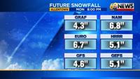
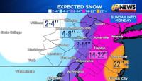
Totals: This is the big one where we’ve made some noticeable changes. As the Nor’Easter really ramps up later this evening and tonight, it will produce some very intense snow bands that no doubt look to hit the Shore and a lot of New Jersey pretty hard. But the big question that has remained is just how far inland will these heavy snow bands get? The track of the storm of course is key to this, but also, there will be a strong surge of dry and sinking air on the western side of the storm that often happens when these low-pressure systems rapidly deepen and strengthen. Because of that, we anticipate a sharp gradient in snowfall totals on the western side of the storm which likely comes more into play now across the heart of our region. With that, we’ve now put most of Berks and the Lehigh Valley in the 4 to 8 inch zone with amounts closer to 8 inches the closer you are to the Delaware River and amounts closer to 4 inches once you get out to Berks County. And west of Berks getting out into Schuylkill and Lebanon Counties, snowfall totals may actually be even lower more on the order of 2 to 4 inches. A narrow swath of 8 to 14 inches of snow is expected across the higher elevations of the Poconos, then down along the Delaware River and getting into far southeastern Pennsylvania. Then, snowfall totals rapidly increase on the order of 14 to 22 inches east of the Delaware River including much of New Jersey. And finally, there could be some snowfall amounts up to 2 feet if not a little more as one approaches the Shore.

Maxuser
TRACK THE WEATHER:
LINKS: HOUR BY HOUR | RADAR | TRAFFIC