
ALERT: Accumulating Snow Overnight Sunday In South Central Pennsylvania
Winter Storm Warnings are in effect for the entire Susquehanna Valley through 1 p.m. Monday. Several inches of snow is likely to accumulate this evening and overnight. The heaviest snow will be east of the Susquehanna River.
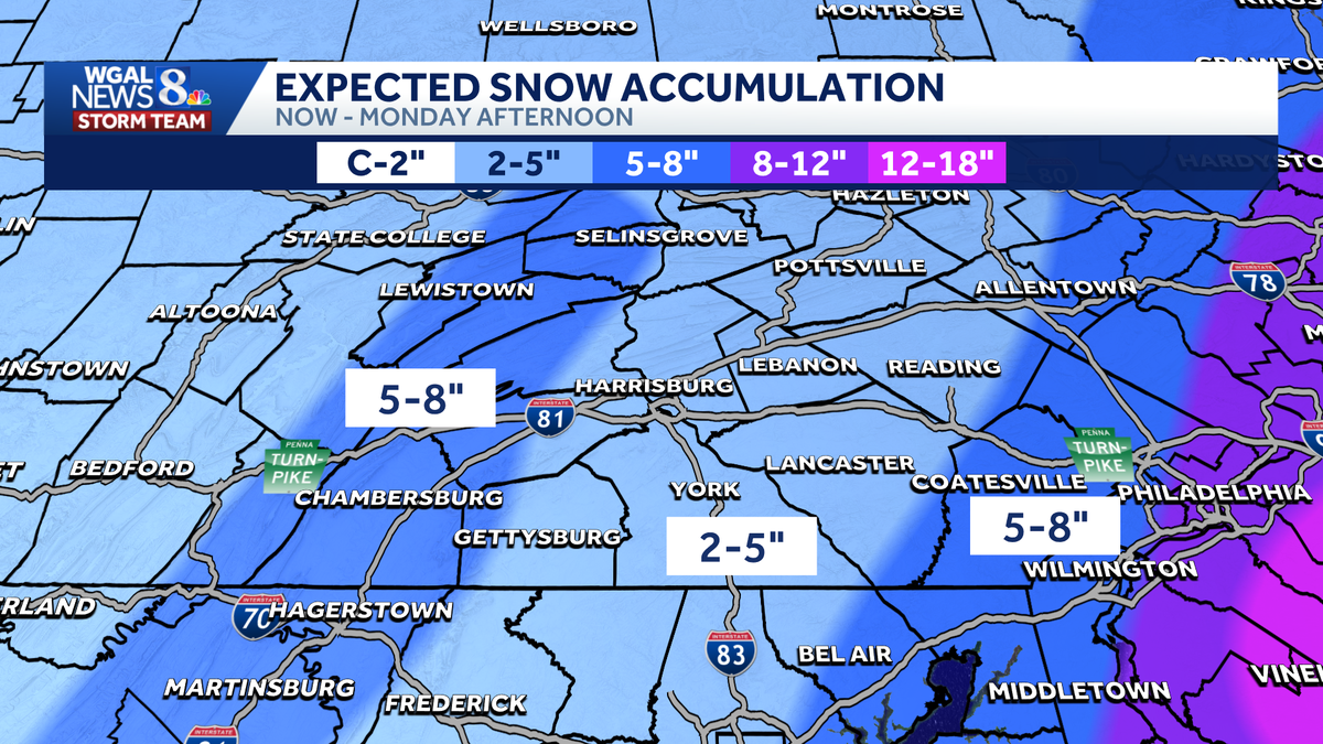
Good Sunday evening, everyone. Here’s *** look at the updated snowfall forecast for the Susquehanna Valley. We’re looking at 2 to 5 inches in where the light blue is. That includes Harrisburg as well as Lebanon, Lancaster, York, and even Gettysburg here. The snow totals have gone down from earlier expectations as the storm has shifted *** little bit to the east, and that took the heavy snow along with it. We’re also looking at 5 to 8 inches though for our western counties because of elevation differences there. That’s helping to add *** little more snow for them. So that’s why you expect *** little bit higher totals there. As we go off to the east though, notice how quickly the snow totals ramp up from Lancaster County all the way towards Philadelphia. Again, that’s because that storm system has shifted to the east, but it’s actually not the only reason. The track is the big one. That 25 mile difference is significant, and that is why we saw partly the big change. The other one is sinking air aloft above our heads. We’re in between two areas of rising motion. What goes up must come down, and that sinking air causes dry air to form. And when you have dry air. Snow totals don’t like that, so that’s why you’re seeing lower totals in response to that. Rain and surface temperatures this afternoon did not help us out either. We were above freezing for the entire afternoon. Now the sun has gone down, temperatures dropped, and snow is sticking, but it ate away at the snow totals. Some of you may have saw snow for 2, maybe even 3 hours. It didn’t stick because your surface temperature was 34, 35 degrees. But now that the snow is sticking, we do anticipate to accumulate pretty quickly across the area. Winter storm warnings are in effect for everyone. Until 1 o’clock Monday afternoon if you’re off to the east along I-95, blizzard warnings are in effect for them. Not only are they expecting higher snow totals, stronger winds could lead to blizzard conditions along I-95. Here in Lancaster, we will see some blowing snow across the area here that could also occur tomorrow as winds will be strong as well. But as we take *** look at the temperatures at this hour, it’s around 6:30 this evening. Temperatures are starting to get down to that freezing mark, 32 in Elizabethtown as well as Lancaster, 36 though. Gettysburg, 34 in Carlisle and 33 in Camp Hill as well as Harrisburg and also off to the west there in Chambersburg. So we are still seeing some of those temperatures above freezing, but now that we will see the sun go down, we’re switching over to all snow for the Susquehanna Valley here because see *** you hold out spots there with some mixing, but this system is also starting to gain strength. See these brighter whites here to our south and east? That’s that heavy banding that we were watching and we’re concerned about here. It does look like it’s. Going to be just to our east in Berks and Chester County, so it’s really close. If you are on the border with Lebanon and Lancaster County, some of that may clip you just *** little bit, but I think the majority of it now just stays off to our east. And again, that is part of the reason why you saw the lower snow totals as we go through the rest of the evening tonight, we will continue with the all snow periods of snow here, light to moderate at times, and then becoming maybe even heavy as we go into the overnight hours after midnight. That’s when the bulk of this is going to come through and. Winds will also pick up, so you’re gonna have blowing snow along with this as we go into the overnight hours and tomorrow morning. Temperatures right around 30 degrees, so it will stick and accumulate. Tomorrow itself, mostly cloudy. The snow will come to an end as we head towards the afternoon. 36 is going to be the highest, so that’s helpful because that will warm up the roads and maybe even get us *** little sunshine here to help warm things up and melt anything that accumulates on sidewalks and roadways for your Monday. But as we go through the next several hours, again, that all snow now, we’re going to be watching. That period of snow as we go through the overnight hours here across the area, we’ll keep an eye on our eastern counties as we will be dealing with some of that banding there along I-95 and also to the east as we get to 6 o’clock in the morning, that’s when our western counties start to see things shut off for you and then by 11 o’clock in the morning, midday tomorrow, uh, noontime, we will start to see things wrap up completely for the Susquehanna Valley. So this storm system will come to an end by tomorrow afternoon and now that it’s after dark, it’s still going to accumulate. 2 to 5 inches again for most of us, with 5 to 8 inches in eastern Lancaster County and then in western counties again, Mifflin, Juniata, Perry, for example, Adams and Franklin County, and even parts of Cumberland County where we have higher elevation, that’s where we’re going to see those 5 to 8 totals across the area. The winds are going to pick up tomorrow and overnight tonight as well. They will peak tomorrow as the storm. Pulls away here right around the midday hours so that’s going to cause some blowing snow around and will reduce visibility. So just be aware of that as you’re going to be out Monday afternoon and Monday evening. The good news is we get *** bit of *** break here on Tuesday. It’s cold, 32 for the high, but at least it will be dry. *** little system comes through on Tuesday night and Wednesday morning, offers some snow showers. Not *** big deal, but *** few snow showers there. Another system could bring us some rain, snow mix on Thursday and into early Friday. Finally, we get *** dry weekend, Saturday and Sunday as we welcome in meteorological spring this upcoming weekend with highs in the mid to upper 40s. And then you can see we’re watching another disturbance early the following week that could also bring us *** little bit of *** rain snow mix. We’ll have more updates throughout the evening.
ALERT: Accumulating Snow Overnight Sunday In South Central Pennsylvania
Winter Storm Warnings are in effect for the entire Susquehanna Valley through 1 p.m. Monday. Several inches of snow is likely to accumulate this evening and overnight. The heaviest snow will be east of the Susquehanna River.

Updated: 7:07 PM EST Feb 22, 2026
Good evening WINTER STORM WARNINGS are in effect for the entire area until 1 p.m. Monday. The News 8 Storm Team has declared today an Alert Day.Heading into the evening, the snow intensity increases, becoming more moderate to heavy at times. Snow, heavy at times, will continue overnight, resulting in accumulations between 2 to 5” for most of the Susquehanna Valley. Parts of Lancaster, Mifflin, Juniata, Perry, Cumberland, Adams, and Franklin Counties may see 5 to 8” of snow by the end of the storm. Highs today remain in the mid 30s.Tonight, in addition to snow continuing, low pressure deepens off the coast, causing the wind to increase 10-20 mph, with gusts 30 to 35. By Monday, they will be out of the northwest 15 to 25 mph, with gusts close to 40 mph.On Monday, the snow winds down early. It may linger longer in far eastern areas until around noon. Skies remain mostly cloudy until evening, when clouds begin to partially clear. Gusty winds remain into Tuesday but lighten up during the day. There will be more sunshine; however, with highs only in the low 30s, wind chills will be in the 20s.A quick-moving clipper brings a mix early Wednesday morning. The rest of the day features plenty of clouds with highs in the low 40s.Thursday, another system brings a chance for rain and snow, which should exit early Friday, leaving the rest of the day with a mix of clouds and sunshine. Highs in the low 40s both days.Next weekend looks dry and pleasant, with milder temperatures. We are watching another disturbance that may bring more unsettled weather to the Susquehanna Valley during the first week of March.Have a great night!
Good evening
WINTER STORM WARNINGS are in effect for the entire area until 1 p.m. Monday. The News 8 Storm Team has declared today an Alert Day.
Heading into the evening, the snow intensity increases, becoming more moderate to heavy at times. Snow, heavy at times, will continue overnight, resulting in accumulations between 2 to 5” for most of the Susquehanna Valley. Parts of Lancaster, Mifflin, Juniata, Perry, Cumberland, Adams, and Franklin Counties may see 5 to 8” of snow by the end of the storm. Highs today remain in the mid 30s.
Tonight, in addition to snow continuing, low pressure deepens off the coast, causing the wind to increase 10-20 mph, with gusts 30 to 35. By Monday, they will be out of the northwest 15 to 25 mph, with gusts close to 40 mph.
On Monday, the snow winds down early. It may linger longer in far eastern areas until around noon. Skies remain mostly cloudy until evening, when clouds begin to partially clear. Gusty winds remain into Tuesday but lighten up during the day. There will be more sunshine; however, with highs only in the low 30s, wind chills will be in the 20s.
A quick-moving clipper brings a mix early Wednesday morning. The rest of the day features plenty of clouds with highs in the low 40s.
Thursday, another system brings a chance for rain and snow, which should exit early Friday, leaving the rest of the day with a mix of clouds and sunshine. Highs in the low 40s both days.
Next weekend looks dry and pleasant, with milder temperatures. We are watching another disturbance that may bring more unsettled weather to the Susquehanna Valley during the first week of March.
Have a great night!