
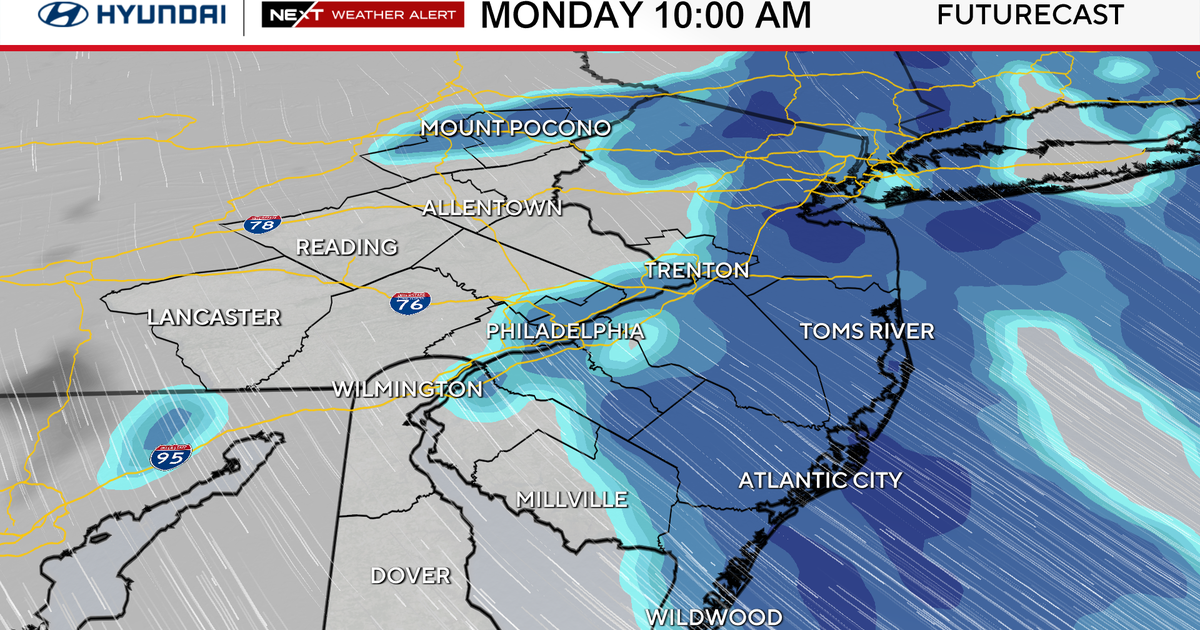
Blizzard and winter weather warnings remain in effect through Monday night in the Philadelphia region as a nor’easter dumps snow across the Delaware Valley.
The storm has officially become a bomb cyclone, with a pressure drop of 25 mb in the past 24 hours. Strong winds and heavy snow bands will continue through the morning drive hours.
The NEXT Weather Team has issued a NEXT Weather Alert for the heavy snow with 8-14 inches of snow possible in Philadelphia and even more at the Jersey Shore. Power outages are also possible due to the snow and wind. Dozens of schools are closed Monday, while some will have virtual learning days.
Before midnight, 6.5 inches of snow had fallen in Philadelphia and 12 inches of snow was reported in Dennisville, Cape May County.

CBS News Philadelphia
When’s the best time to shovel snow?
Temps will warm slightly into the mid-upper 30s Monday, so the wet snow will remain relatively soft. The NEXT Weather Team recommends spending the time clearing off your driveway, walkways, etc., before it hardens up a bit Monday night into Tuesday.
Be very careful with this heavy, wet snow. It’s called “heart attack snow” for a reason.
What weather alerts are in effect for the snowstorm?Blizzard warning: In effect through Monday at 6 p.m. Includes all of New Jersey, Delaware and southeastern Pennsylvania, including Philadelphia. Also includes the Poconos. Impacts include whiteout conditions, dangerous and impassable roads, downed trees, widespread power outages, high surf, coastal erosion and school closings.Winter storm warning: In effect through Monday at 6 p.m. Includes Berks, Chester and upper Montgomery counties and the Lehigh Valley. Impacts include dangerous roads, low visibility, downed trees and power lines, power outages and travel cancellations.Coastal flood warning: In effect until 5 a.m. Monday. Includes all shore points, back bays and Delaware beaches. Impacts include strong winds that will push water into the area during high tides. Two to three feet of major flooding possible.How much snow are we going to get?
The Lehigh Valley, Berks Chester and upper Montgomery counties are looking at about 6-10 inches of snow.
In Philadelphia, along the I-95 corridor, and in New Jersey and Delaware, at least 8-14 inches of snow could fall. Those totals are expected to be even higher closer to the coast, possibly up to 14-22 inches.

CBS News Philadelphia
NEXT big weather changes
The snowstorm will begin to pull away rapidly between 10 a.m. and noon Monday. Scattered snow showers and high winds will taper by Monday evening.
Temps will head to the 20s Monday night and stay near freezing Tuesday. They will stay below freezing Tuesday night, so all the snow and water will turn into ice.

CBS News Philadelphia
Then, temps will rise to the 40s and 50s Wednesday through Friday. There will be a chance of rain Thursday and Friday. Next weekend in the Delaware Valley looks sunny and mild in the low 50s.
Here’s your 7-day forecast:

CBS News Philadelphia
Monday/NEXT Weather alert: Snow. High 38, low 31.
Tuesday: Mostly sunny, cold. High 33, low 25.
Wednesday: A.m. snow, rain shower. High 48, low 25.
Thursday: Chance rain. High 40, low 32.
Friday: Chance rain. High 44, low 30.
Saturday: Mostly sunny. High 53, low 29.
Sunday: Sun returns. High 53, low 35.
More from CBS News