
HOUR-BY-HOUR | Latest winter storm timing in south-central Pennsylvania
OUTAGES. AND CHRISTINA HERE, WHEN THE WIND STARTS TO WHIP UP, IT COULD BE EVEN WORSE. YEAH, WE COULD SEE SOME MORE OUTAGES RESULTING BECAUSE OF THE WIND. WE ARE GOING TO BE SEEING SOME GUSTS 35 TO 40MPH AS THIS NOR’EASTER CRANKS UP AND PULLS AWAY TODAY. BUT RIGHT NOW WE ARE STILL DEALING WITH SNOW, ALBEIT LIGHT, ESPECIALLY WEST OF THE SUSQUEHANNA RIVER. IT LOOKS FAIRLY LIGHT. I FOUND SOME BRIGHTER RETURNS THOUGH, JUST TO THE EAST OF 81 NEAR SOUTH MOUNTAIN, NEAR WAYNESBORO IN FRANKLIN COUNTY. YOU’RE STILL SEEING SOME LIGHT TO MODERATE SNOW THERE, AND WE ALSO HAVE SOME LIGHT SNOW FALLING IN THE EASTERN PORTIONS OF LANCASTER COUNTY, INCLUDING CHERRY HILL TO NEW HOLLAND, PARADISE AND GAP STRASBURG SEEING THAT, AS WELL AS QUARRYVILLE AND ALL THE WAY SOUTH TOWARD THE SOUTHERN END OF LANCASTER COUNTY, STILL SEEING SOME GOOD RETURNS THERE. NEWS EIGHT STORM TEAM FORECAST TODAY. WE HAVE ALERT THIS MORNING BECAUSE OF THE SNOW IN THE ROAD CONDITIONS, BUT IMPACT THIS AFTERNOON AS THE WINDS CONTINUE. I DO THINK ROADS WILL IMPROVE GREATLY LATER TODAY. LOOK AT OUR HIGHS WELL ABOVE FREEZING. SO WITH SALT AND TREATMENT THE ROADS SHOULD BE JUST FINE LATER. BUT THIS MORNING PLEASE BE CAREFUL AS THEY ARE VERY SLIPPERY AND SLICK. WHEN THAT SNOW IS PACKED DOWN, IT’S HARD TO GET SOME STOPPING DISTANCE, SO PLEASE KEEP A LOT OF ROOM BETWEEN YOU AND THE CAR IN FRONT OF YOU. BUT I DO SEE THE LIGHT SNOW ENDING HERE BY NINE IN MOST SPOTS. A FEW FLURRIES MAY LINGER FAR EAST LATER TODAY. TONIGHT PARTLY CLOUDY. BLUSTERY. FEELS LIKE THE TEENS WITH TEMPERATURES IN THE LOW 20S AND TOMORROW NOT AS WINDY AS TODAY, BUT STILL A LITTLE BIT BRISK. COLDER TO HIGHS WILL REACH THE LOWER 30S, BUT WE DO GET OUR FAIR SHARE OF SUN TOMORROW. YESTERDAY’S HIGH WAS 37 DEGREES, SO THAT’S WHAT STARTED OUT OUR STORM WITH RAIN. WE HAD RAIN TO START AND RAIN AND MELTED. SNOW YESTERDAY ACCUMULATED TO A HALF INCH IN HARRISBURG, 30 DEGREES. RIGHT NOW IN LEWISTOWN IT’S 34. IN LEBANON, 31 FOR LANCASTER AND YORK AND 32 IN HARRISBURG. THAT WIND STARTING TO PICK UP, YOU START TO SEE THE DOUBLE DIGIT WIND SPEEDS, AND THAT IS AFFECTING HOW IT FEELS. SO IT DOES FEEL LIKE THE LOWER 20S IN SOME SPOTS. AND IT WILL FEEL LIKE THE MID TO UPPER 20S LATER TODAY. LOOK AT THIS NOR’EASTER BIG STORM. IT HAD LIGHTNING IN IT OVERNIGHT. THUNDER SNOW ON THE COAST JUST POUNDING SNOW ALL THE WAY FROM MARYLAND AND VIRGINIA UP INTO MAINE. SO THIS IS A HUGE STORM, BUT A LITTLE TOO FAR EAST FOR US TO GET IN ON THE BIG SNOW ON THE BACKSIDE OF THAT STORM. SO THE LIGHT SNOW WILL CONTINUE TO DWINDLE THIS MORNING. I THINK BY NINE, MOST OF IT’S OVER. IT WON’T RULE OUT A FEW FLURRIES OR A FEW SNOW SHOWERS CONTINUING THIS AFTERNOON, BUT THEY WON’T DO ANYTHING TO SLOW YOU DOWN TONIGHT. PARTLY CLOUDY SKIES. TOMORROW WE GET A NICE DOSE OF SUNSHINE, MIX OF CLOUDS AND SUN. HIGHS NEAR FREEZING THOUGH. AND FINALLY, AS WE HEAD INTO WEDNESDAY, I KNOW YOU DON’T WANT TO HEAR ABOUT MORE SNOW, BUT HERE WE GO AGAIN. THERE’S JUST A QUICK CLIPPER THAT COMES IN OVERNIGHT. EARLY WEDNESDAY MORNING COULD PUT DOWN A QUICK COATING TO AROUND AN INCH OF SNOW, BUT IT’S GONE BY AFTERNOON. IN FACT, AS A COLD FRONT COMES IN LATER IN THE DAY, WE SHOULD BE IN THE 40S AHEAD OF THAT FRONT. HERE’S A LOOK AT THE PREDICTOR. ESTIMATED SNOWFALL TOTALS FOR WEDNESDAY AND ANYTHING THAT YOU MIGHT SEE LEFT OVER THIS MORNING REMEMBER THAT DOES INCLUDE SNOW THAT STILL COULD FALL THIS MORNING. MOST SPOTS JUST PICKING UP A COATING EARLY WEDNESDAY. SO HERE’S A LOOK AT THE TEN DAY FORECAST. TEMPERATURES HERE ARE GOING UP AND DOWN ALL WEEK. WE HAVE 30. WE HAVE SOME 40S. IT’S 36 DEGREES ON THURSDAY BUT UP TO 40 DEGREES ON FRIDAY. AND LOOK AT SATURDAY LAST DAY OF FEBRUARY. WAY TO GO OUT WITH A BANG. WE COULD BE UP NEAR 50 DEGREES. FIRST DAY OF MARCH COMING IN FAIRLY QUIET AT 46 AND THEN WINTER IS NOT DONE WITH US. REGINA WE HAVE A CHANCE FOR A WINTRY MIX OF PROLONGED WIN
HOUR-BY-HOUR | Latest winter storm timing in south-central Pennsylvania

Updated: 6:11 AM EST Feb 23, 2026
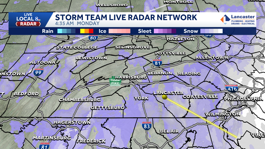
The WGAL News 8 Storm Team continues to track a winter storm that brought accumulating snow to the Susquehanna Valley Sunday into Monday morning. Although the snow is winding down, impacts will continue as winds strengthen and roads turn slick. Hour-by-hour Start of the storm: The winter storm began on Sunday with a rain/snow mix before changing to mostly snow around sunset. The snow intensified overnight, with periods of moderate to heavy, wet snow. Monday morning: Storm continues with light snow ending around 9 a.m. for most of south-central Pennsylvania as the nor-easter pulls away. Roads will be slushy and slick. Monday afternoon: A few flurries may linger, mainly in the eastern counties. Winds will strengthen, leading to possible blowing snow, power outages and downed trees.What to know Alert Morning: Monday until 10 a.m. as the snow tapers. Impact Day: The rest of Monday as winds strengthen. Winter storm warning: In effect for Lancaster and Lebanon counties until 1 p.m. Monday. Winter storm advisory: In effect for Adams, Cumberland, Dauphin, Franklin, Juniata, Mifflin, Perry and York counties until 1 p.m. Monday. Totals Most of the Susquehanna Valley: 2 to 5 inches of snow.Heaviest totals (parts of Mifflin, Juniata, Perry, Cumberland, Franklin, Adams, and eastern parts of Lancaster counties): 5 to 8 inches of snow are possible by the end of the storm.Travel conditions Expect hazardous travel, with wet/slushy and snow-covered roads, especially in untreated areas. Avoid nonessential travel on Monday morning if possible.If you must travel, pack emergency supplies, allow extra time, and monitor local forecasts for updates. WGAL weather linksWatch it: Use WGAL’s interactive radar to track storms.Get alerts that follow you: Turn on location-based weather alerts with WGAL’s step-by-step instructions.Check what’s closed: See closings and delays for businesses, churches, and organizations during severe weather.Navigate smarter: Open WGAL’s interactive traffic map for crashes, construction, and road closures—with traffic cameras.Inbox updates: Sign up for email alerts, from daily forecasts to severe-weather warnings.Plan by the hour: View the hour-by-hour forecast for your day.Weekend ready: Preview the weekend forecast before you lock in plans.Look ahead: Browse the 10-day forecast for the extended outlook.
The WGAL News 8 Storm Team continues to track a winter storm that brought accumulating snow to the Susquehanna Valley Sunday into Monday morning.
Although the snow is winding down, impacts will continue as winds strengthen and roads turn slick.

Hour-by-hour
Start of the storm: The winter storm began on Sunday with a rain/snow mix before changing to mostly snow around sunset. The snow intensified overnight, with periods of moderate to heavy, wet snow. Monday morning: Storm continues with light snow ending around 9 a.m. for most of south-central Pennsylvania as the nor-easter pulls away. Roads will be slushy and slick. Monday afternoon: A few flurries may linger, mainly in the eastern counties. Winds will strengthen, leading to possible blowing snow, power outages and downed trees.

What to know Alert Morning: Monday until 10 a.m. as the snow tapers.
Impact Day: The rest of Monday as winds strengthen.
Winter storm warning: In effect for Lancaster and Lebanon counties until 1 p.m. Monday.
Winter storm advisory: In effect for Adams, Cumberland, Dauphin, Franklin, Juniata, Mifflin, Perry and York counties until 1 p.m. Monday.

Totals Most of the Susquehanna Valley: 2 to 5 inches of snow.Heaviest totals (parts of Mifflin, Juniata, Perry, Cumberland, Franklin, Adams, and eastern parts of Lancaster counties): 5 to 8 inches of snow are possible by the end of the storm.

Hearst OwnedWGAL News 8 Storm Team
Travel conditions Expect hazardous travel, with wet/slushy and snow-covered roads, especially in untreated areas. Avoid nonessential travel on Monday morning if possible.If you must travel, pack emergency supplies, allow extra time, and monitor local forecasts for updates. WGAL weather links