
Winter isn’t done with us yet with snow occurring today and more snow looking likely on Wednesday and Thursday.
Any Alert Days Ahead? Yes. Today is a First Alert Weather Day due to snow in Westmoreland and Fayette counties among other places to the east. There is a hance for additional First Alert Weather Days on Wednesday and Thursday.
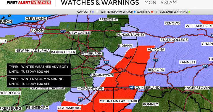
Aware: A winter storm warning was issued for the ridges of Westmoreland and Fayette counties through 1 a.m. tonight.
As much as six inches of snow is possible in higher elevations today, with Pittsburgh likely seeing around an inch. An additional four to seven inches of snow could fall in the Pittsburgh area over the next week.

KDKA Weather Center
Communities in parts of Westmoreland and Fayette counties are expected to see at least three inches of snow and maybe as much as six inches of snow through midnight. Communities immediately surrounding these places are expected to see between one and three inches of additional snow today and are under winter weather advisories.
Several school districts in the Pittsburgh area issued two-hour delays Monday due to the winter weather.
Even if you are not included under a warning or advisory, you should be aware of potential slick spots with the highest chance for hitting one happening this morning. The reason for today’s snow is due to how the winds are situated. There also seems to be a little bit of enhancement due to moisture from Lake Erie.

KDKA Weather Center
The brunt of the nor’easter, including snow totals of more than 20 inches expected on Long Island, continues to pummel the East Coast. This historic system is causing not only a local travel impact on the East Coast, but also national issues when it comes to flights being delayed. Baltimore is a major hub of Southwest Airlines.
Back to our forecast here, we have two more snow systems expected to slide by this week. The first arrives late Tuesday evening, wrapping up on Wednesday morning. The second comes on Thursday afternoon, wrapping up well before the Friday morning commute. I would expect a number of school delays on Wednesday morning due to the timing of the snow. Thursday’s snow chance won’t impact the morning commute, but may have a bigger impact due to a winter mix expected to fall during the evening commute and while schools are letting out. There is a possibility that schools could decide to end the school day a little early on Thursday due to icy conditions being possible. At this point, it looks like we should expect around two to four inches of snow on Wednesday with an additional one of two inches of snow with a wintry mix on Thursday.
Highs today will be near 30 degrees. Today’s low temperature will be hit just before midnight. I have us dropping down to 20 for our midnight temperature. Tuesday morning lows have dipped into the teens, with wind chills in single digits.
I have today as the coolest day of the week with highs in the mid to low 30s on Tuesday and 40s expected for highs starting on Wednesday and going through Friday.

KDKA Weather Center
The warmest day of the week will likely be on Saturday, where I am forecasting a high of 54 degrees.
More from CBS News