
ALERT: Snow continues, winds strengthen across south-central Pennsylvania
Alright, so we still have the snow, but it is winding down in many spots. You can already see some breaks in the radar, and although the snow is still falling, it’s fairly light, so it’s not going to do much to add to additional accumulation or cause too much travel trouble this morning, especially if roads are salted. They’re going to be in good shape because look at the temperatures. We’re right around freezing, so that does bode well for us. Later today as we get into the upper 30s, and although it will stay cloudy, the road should be just wet later this morning into the afternoon if you need to head out then. Here’s *** look at your feels like temperatures. Winds are starting to pick up, so this is going to come into play today. Feels like the low 20s now, and it will continue to feel like the 20s this afternoon. So as the snow continues to fall and we Still pulling away from the storm. I’ll keep an alert for you this morning, especially since road conditions are still dicey in some spots. But later today, the impact is for the wind. We could have some gusts 35 to 40 MPH, which could blow down some branches, especially because they’re so heavy and wet, and cause some isolated power outages. So we’ll keep you updated on those changes coming up.
ALERT: Snow continues, winds strengthen across south-central Pennsylvania

Updated: 5:06 AM EST Feb 23, 2026
A winter storm continues across south-central Pennsylvania, bringing accumulating snow. Monday is an Alert Morning until 10 a.m. as the storm tapers, and then we transition into an Impact Day as winds strengthen. Storm timing The winter storm began Sunday as a rain/snow mix, then changed to mostly snow after sunset.Snow intensified overnight, with periods of moderate to heavy snowfall and accumulating totals.Snow continues Monday morning and should end around 9 a.m. A few flurries may linger into the afternoon, mainly in the eastern counties.Advisory, warningWinter weather advisory: In effect for Adams, Cumberland, Dauphin, Franklin, Juniata, Mifflin, Perry and York counties until 1 p.m. Monday. Winter storm warning: In effect for Lancaster and Lebanon counties until 1 p.m. Monday. TotalsMost of the Susquehanna Valley will see 2 to 5 inches of snow.Heaviest totals (parts of Mifflin, Juniata, Perry, Cumberland, Franklin, Adams, and eastern parts of Lancaster counties): 5 to 8 inches of snow are possible by the end of the storm. Winds strengthenMonday: Northwest winds 15–25 mph with gusts near 40 mph. Impacts: Reduced visibility, blowing/drifting snow, possible downed branches and power interruptions. Travel conditionsExpect hazardous travel, with wet/slushy and snow-covered roads.Avoid nonessential travel on Monday morning if possible.If you must travel, pack emergency supplies, allow extra time, and monitor local forecasts for updates. WGAL weather linksWatch it: Use WGAL’s interactive radar to track storms.Get alerts that follow you: Turn on location-based weather alerts with WGAL’s step-by-step instructions.Check what’s closed: See closings and delays for businesses, churches, and organizations during severe weather.Navigate smarter: Open WGAL’s interactive traffic map for crashes, construction, and road closures—with traffic cameras.Inbox updates: Sign up for email alerts, from daily forecasts to severe-weather warnings.Plan by the hour: View the hour-by-hour forecast for your day.Weekend ready: Preview the weekend forecast before you lock in plans.Look ahead: Browse the 10-day forecast for the extended outlook.
A winter storm continues across south-central Pennsylvania, bringing accumulating snow.
Monday is an Alert Morning until 10 a.m. as the storm tapers, and then we transition into an Impact Day as winds strengthen.
Storm timing The winter storm began Sunday as a rain/snow mix, then changed to mostly snow after sunset.Snow intensified overnight, with periods of moderate to heavy snowfall and accumulating totals.Snow continues Monday morning and should end around 9 a.m. A few flurries may linger into the afternoon, mainly in the eastern counties.

Advisory, warning
Winter weather advisory: In effect for Adams, Cumberland, Dauphin, Franklin, Juniata, Mifflin, Perry and York counties until 1 p.m. Monday. Winter storm warning: In effect for Lancaster and Lebanon counties until 1 p.m. Monday.

TotalsMost of the Susquehanna Valley will see 2 to 5 inches of snow.Heaviest totals (parts of Mifflin, Juniata, Perry, Cumberland, Franklin, Adams, and eastern parts of Lancaster counties): 5 to 8 inches of snow are possible by the end of the storm.

Hearst OwnedWGAL News 8 Storm Team
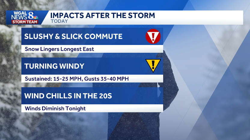
Winds strengthenMonday: Northwest winds 15–25 mph with gusts near 40 mph. Impacts: Reduced visibility, blowing/drifting snow, possible downed branches and power interruptions.


Travel conditionsExpect hazardous travel, with wet/slushy and snow-covered roads.Avoid nonessential travel on Monday morning if possible.If you must travel, pack emergency supplies, allow extra time, and monitor local forecasts for updates.

WGAL weather links