
Tuesday brings a brief break from the snow, but not the chill. High temperatures will run close to freezing. A little breeze pulls the feels like temperature into the 20s.A quick round of light snow arrives late tonight, prompting an Impact Day for the Wednesday morning commute.Another chilly dayThe chill continues with temperatures in the lower 30s under more clouds than sunshine. Most of the day gives us a break from the wintry weather. A quick round of light snow pushes through western Pennsylvania after midnight. Impact Day: Light snow through Wednesday’s morning commuteA Winter Weather Advisory goes into effect at 9 p.m. for Clarion, Indiana and Venango counties along with eastern Fayette and Westmoreland counties. The advisory will last through 1 p.m. Wednesday.The first of two quick-hitting systems arrives after midnight. One to two inches of snow are possible, with slightly higher amounts for spots near I-80 and the ridges. The most widespread snow falls between 2 a.m. and 7 a.m.Slick spots could be around for the morning commute. Wednesday will begin with an Impact Day. The snow exits for late-morning commuters.Next system ThursdayThe track for Thursday is still a little tricky. Some details are coming into better view. The impacts will be greater for areas south of Pittsburgh. Any precipitation will arrive a little later in the day – late morning or early afternoon. What falls is still a question. Rain and/or snow showers are possible south of I-70. Temperatures for the rest of western Pennsylvania will be in the 30s. We will continue to monitor the trends. Conditions will settle down with milder temperatures heading into the weekend. Sunshine returns Friday. Saturday is your pick of the weekend, at this point, with highs in the mid 50s. Another system arrives early next week.TODAY: Chilly with sunshine at times. High: 34°.TONIGHT – Impact Day: Light snow arrives after midnight. Low: 30°.WEDNESDAY – Impact Day: Morning snow showers, mostly cloudy and milder afternoon. High: 44°, low: 25°.THURSDAY: Rain and snow showers possible, especially south of Pittsburgh. High: 40°, low: 24°.FRIDAY: Sunshine returns. High: 48°, low: 34°.
PITTSBURGH —
Tuesday brings a brief break from the snow, but not the chill. High temperatures will run close to freezing. A little breeze pulls the feels like temperature into the 20s.
A quick round of light snow arrives late tonight, prompting an Impact Day for the Wednesday morning commute.
Another chilly day
The chill continues with temperatures in the lower 30s under more clouds than sunshine. Most of the day gives us a break from the wintry weather. A quick round of light snow pushes through western Pennsylvania after midnight.
Impact Day: Light snow through Wednesday’s morning commute
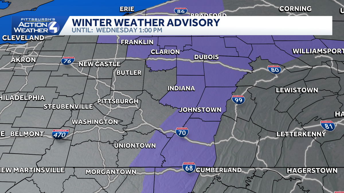
A Winter Weather Advisory goes into effect at 9 p.m. for Clarion, Indiana and Venango counties along with eastern Fayette and Westmoreland counties. The advisory will last through 1 p.m. Wednesday.

Hearst Owned
A Winter Weather Advisory for areas north and east through the first half of the day Wednesday.
The first of two quick-hitting systems arrives after midnight. One to two inches of snow are possible, with slightly higher amounts for spots near I-80 and the ridges. The most widespread snow falls between 2 a.m. and 7 a.m.
Slick spots could be around for the morning commute. Wednesday will begin with an Impact Day. The snow exits for late-morning commuters.

Hearst OwnedHearst
Wednesday’s Impact Day is for light snow. Accumulations of 1″-2″ for most, higher north and east.
Next system Thursday
The track for Thursday is still a little tricky. Some details are coming into better view. The impacts will be greater for areas south of Pittsburgh. Any precipitation will arrive a little later in the day – late morning or early afternoon. What falls is still a question. Rain and/or snow showers are possible south of I-70. Temperatures for the rest of western Pennsylvania will be in the 30s. We will continue to monitor the trends.
Conditions will settle down with milder temperatures heading into the weekend. Sunshine returns Friday. Saturday is your pick of the weekend, at this point, with highs in the mid 50s. Another system arrives early next week.

TODAY: Chilly with sunshine at times. High: 34°.
TONIGHT – Impact Day: Light snow arrives after midnight. Low: 30°.
WEDNESDAY – Impact Day: Morning snow showers, mostly cloudy and milder afternoon. High: 44°, low: 25°.
THURSDAY: Rain and snow showers possible, especially south of Pittsburgh. High: 40°, low: 24°.
FRIDAY: Sunshine returns. High: 48°, low: 34°.