
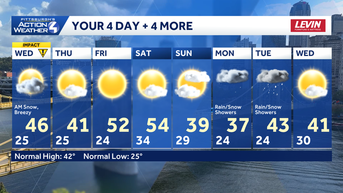
The morning commute could be tricky with falling and accumulating snow. Amounts will be light through 8 a.m. Windy this afternoon as the snow starts to melt. A warming trend takes over through the start of the next weekend.Impact Day: Light snow accumulations this morningA Winter Weather Advisory lasts until 1 p.m. for Clarion, Indiana and Venango counties along with eastern Fayette and Westmoreland counties. A quick-hitting clipper will produce one to two inches of snow with higher amounts for spots near I-80 and the ridges. The most widespread snow falls through 7 a.m. with slick spots for the morning commute. Temperatures will warm into the mid 40s. So, the snow will melt through the day. It will be a windy afternoon with gusts over 30 mph.Trending milder through SaturdayThursday’s system is now on track to miss us all together. More clouds are expected south of Pittsburgh and everyone will run a little cooler with highs near 40 degrees.Temperatures go on a milder run with highs in the 50s heading into the weekend. Sunshine will be an added bonus Friday and Saturday.Messy start to next weekA few flurries are possible Saturday night followed by another round of chilly air to end the weekend. We are tracking better precipitation chances Monday and Tuesday. Back-to-back systems are possible with periods of rain and snow.TODAY – Impact Day: Snow before 8 a.m. Partly cloudy, breezy and milder. High: 46°.TONIGHT: Re-freezing possible under partly cloudy skies. Low: 25°.THURSDAY: Sun and clouds with seasonal temperatures. High: 41°, low: 24°.FRIDAY: Warmer with sunshine. High: 52°, low: 34°.SATURDAY: Increasing clouds. High: 54°, low: 29°.
PITTSBURGH —
The morning commute could be tricky with falling and accumulating snow. Amounts will be light through 8 a.m. Windy this afternoon as the snow starts to melt. A warming trend takes over through the start of the next weekend.
Impact Day: Light snow accumulations this morning
A Winter Weather Advisory lasts until 1 p.m. for Clarion, Indiana and Venango counties along with eastern Fayette and Westmoreland counties.
A quick-hitting clipper will produce one to two inches of snow with higher amounts for spots near I-80 and the ridges. The most widespread snow falls through 7 a.m. with slick spots for the morning commute.
Temperatures will warm into the mid 40s. So, the snow will melt through the day. It will be a windy afternoon with gusts over 30 mph.
Trending milder through Saturday
Thursday’s system is now on track to miss us all together. More clouds are expected south of Pittsburgh and everyone will run a little cooler with highs near 40 degrees.
Temperatures go on a milder run with highs in the 50s heading into the weekend. Sunshine will be an added bonus Friday and Saturday.
Messy start to next week
A few flurries are possible Saturday night followed by another round of chilly air to end the weekend. We are tracking better precipitation chances Monday and Tuesday. Back-to-back systems are possible with periods of rain and snow.
TODAY – Impact Day: Snow before 8 a.m. Partly cloudy, breezy and milder. High: 46°.
TONIGHT: Re-freezing possible under partly cloudy skies. Low: 25°.
THURSDAY: Sun and clouds with seasonal temperatures. High: 41°, low: 24°.
FRIDAY: Warmer with sunshine. High: 52°, low: 34°.
SATURDAY: Increasing clouds. High: 54°, low: 29°.