
GOOD MORNING. WE HAVE A QUICK MOVING CLIPPER MOVING THROUGH THE SUSQUEHANNA VALLEY THIS MORNING. WE’VE HAD SOME SNOW FALLING, BUT NOT NECESSARILY REACHING THE GROUND. THERE IS STILL A BAND OF SNOW OUT TO OUR WEST. I’LL KEEP AN EYE ON THAT AS THAT COULD BRING IN SOME SCATTERED SNOW SHOWERS THIS MORNING. BUT I THINK THE IMPACT IS PRETTY LOW FOR US HERE TO CAUSE ANY ISSUES DURING THE MORNING RUSH. TEMPERATURE CHECK. IT’S 31 IN HARRISBURG, 32, CARLISLE, 33, IN CHAMBERSBURG AS WELL AS YORK. AND WE DON’T HAVE MUCH OF A WIND TODAY. WIND SPEEDS ARE GOING TO BE RANGING FROM ABOUT 5 TO 15MPH. SO NOT AS WINDY AS YESTERDAY AND NOT AS COLD AS YESTERDAY. SCATTERED SNOW SHOWERS AROUND THIS MORNING. COOL TEMPERATURES IN THE 30S FOR THE AFTERNOON. MOSTLY CLOUDY, SOME PEEKS OF SUN. WE GET TO 46 AND THERE JUST COULD BE A STRAY SHOWER AROUND LATER THIS AFTERNOON OR THIS EVENING. AS A COLD FRO
Scattered snow showers possible in south-central Pennsylvania

Updated: 5:15 AM EST Feb 25, 2026
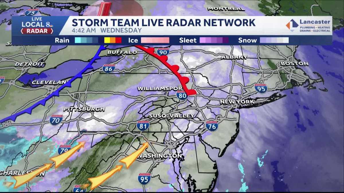
Scattered snow showers could bring a light coating of snow during the Wednesday morning commute in south-central Pennsylvania. The WGAL News 8 Storm Team is tracking a clipper that is expected to quickly sweep through the region, making Wednesday an Impact Morning from 1 a.m. to 8 a.m. TimingEarly morning (after 1 a.m.): A clipper arrives from northwest to southeast with light snow.Throughout the morning: Scattered snow showers move through the Susquehanna Valley, though it may be difficult for the snow to reach the ground. Around 8 a.m.: Snow ends.Afternoon: Temperatures warm up, melting any accumulation. TotalsParts of the Susquehanna Valley should see a light coating of snow, with the best chances along and north of the Pennsylvania Turnpike. Some areas may see no accumulation. Temperatures Wednesday: Temperatures warm to near 32 degrees by sunrise; Highs around 46 degrees, melting any snow from the morning.ImpactsOverall: Low-impact eventAny accumulation of snow on the roads could impact the morning commute and create slick driving conditions. Drivers are advised to go slow and allow extra time for travel. Looking aheadThe WGAL News 8 Storm Team is closely monitoring another system that could bring a few showers south of the Pennsylvania Turnpike, though that chance has been decreasing. The Storm Team is also tracking a chance for snow into Monday, followed by another system on Tuesday that could briefly start as snow or a wintry mix before changing to rain. SOUTH-CENTRAL PA WEATHER RESOURCES: INTERACTIVE RADAR | ACTIVE WEATHER ALERTS | CURRENT CONDITIONS | HOURLY FORECAST | 10-DAY FORECAST | WEEKEND FORECAST | MAP ROOM | DOWNLOAD THE APP | WEATHER EMAILS
Scattered snow showers could bring a light coating of snow during the Wednesday morning commute in south-central Pennsylvania.
The WGAL News 8 Storm Team is tracking a clipper that is expected to quickly sweep through the region, making Wednesday an Impact Morning from 1 a.m. to 8 a.m.

TimingEarly morning (after 1 a.m.): A clipper arrives from northwest to southeast with light snow.Throughout the morning: Scattered snow showers move through the Susquehanna Valley, though it may be difficult for the snow to reach the ground. Around 8 a.m.: Snow ends.Afternoon: Temperatures warm up, melting any accumulation.

Totals
Parts of the Susquehanna Valley should see a light coating of snow, with the best chances along and north of the Pennsylvania Turnpike. Some areas may see no accumulation. Temperatures
Wednesday: Temperatures warm to near 32 degrees by sunrise; Highs around 46 degrees, melting any snow from the morning.

ImpactsOverall: Low-impact eventAny accumulation of snow on the roads could impact the morning commute and create slick driving conditions. Drivers are advised to go slow and allow extra time for travel. Looking ahead
The WGAL News 8 Storm Team is closely monitoring another system that could bring a few showers south of the Pennsylvania Turnpike, though that chance has been decreasing.
The Storm Team is also tracking a chance for snow into Monday, followed by another system on Tuesday that could briefly start as snow or a wintry mix before changing to rain.
![]()
SOUTH-CENTRAL PA WEATHER RESOURCES: INTERACTIVE RADAR | ACTIVE WEATHER ALERTS | CURRENT CONDITIONS | HOURLY FORECAST | 10-DAY FORECAST | WEEKEND FORECAST | MAP ROOM | DOWNLOAD THE APP | WEATHER EMAILS