
The Brief
A major winter storm will continue to bring snow to Pennsylvania, New Jersey, and Delaware Monday morning.
More than 18 inches have already been reported after snow continued to fall overnight.
Blizzard-like winds will also continue Monday causing some snow drifting.
PHILADELPHIA – Expect snow showers to continue through Monday morning across most of the Delaware Valley as a major winter storm continues to impact the Philadelphia area.
That storm had already dropped 18 inches of snow or more on parts of the area overnight.
What to expect the rest of the week
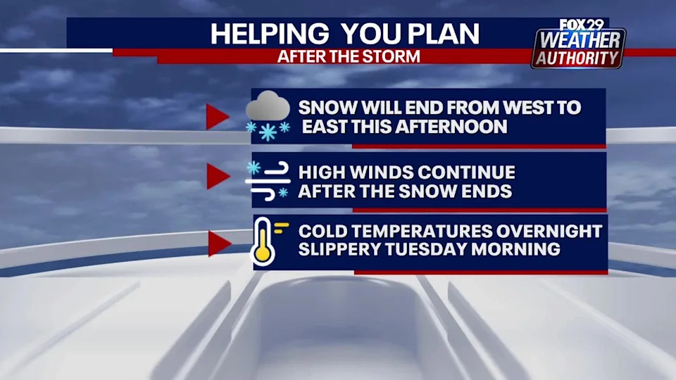
After Sunday’s snowstorm, the National Weather Service (NWS) reports, black ice could develop on roads in the region Monday night. With lows bottoming out in the teens to low 20s.
The City of Philadelphia will lift its Snow Emergency at 6:00 a.m., Tuesday, February 24, 2026. While many streets have been cleared, crews will continue to use snow melters and new snow blowers to clear tight areas.
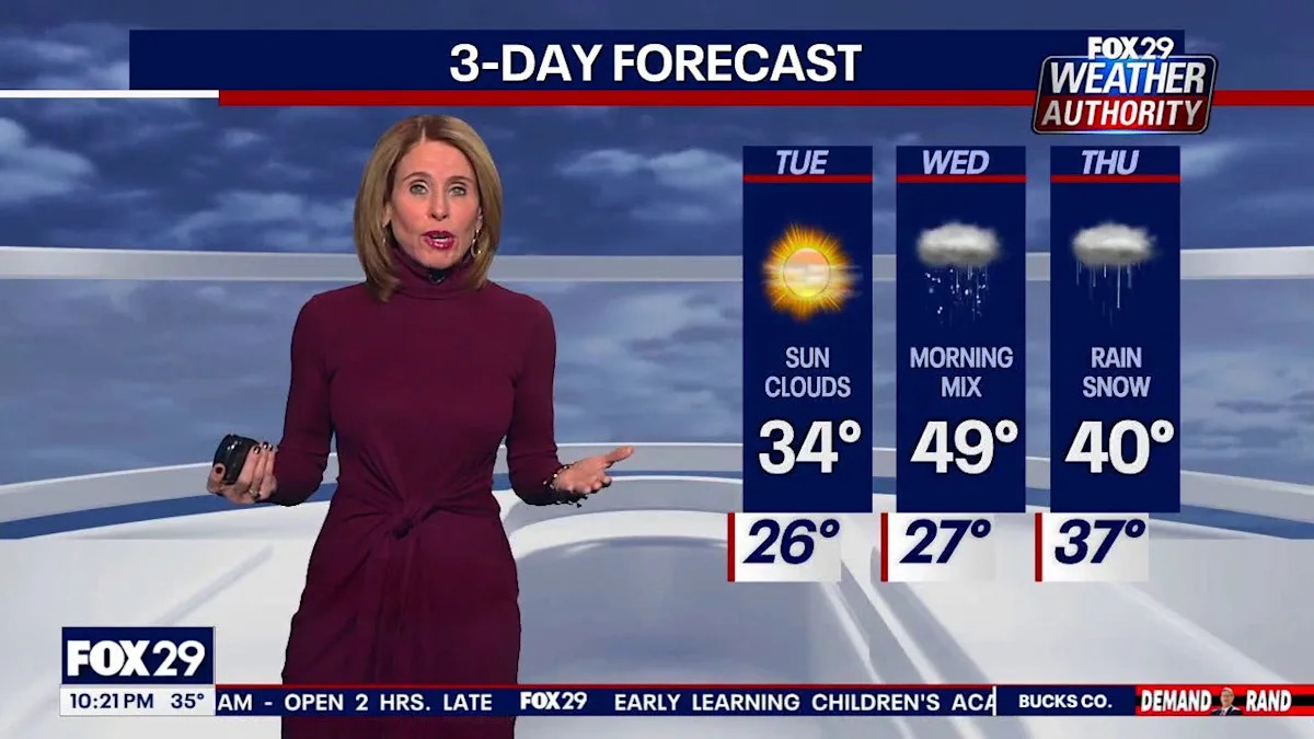
FOX 29 Meteorologist Kathy Orr says two systems of precipitation are expected to form Tuesday overnight and Thursday.
How much more snow can we expect Monday?
FOX 29’s Sue Serio says the snow is expected to continue through at least early Monday afternoon. The snow will taper off from west to east beginning around noon.
The National Weather Service also says heavy snow banding will continue through late morning with snowfall rates of 2″ or greater will continue to be possible during that time.
With 18 inches or more having already fallen in parts of the area, those accumulations could continue to grow through the day Monday, making the predicted snowfall total range of 18-24 inches in some areas entirely possible.
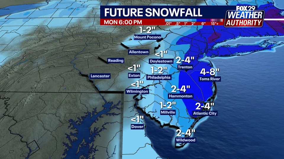
Parts of coastal New Jersey could see another 4–8 inches through Monday morning and early afternoon. Areas south and west of Toms River could see another 2-4 inches, including Trenton.
Most can expect another inch or two through Monday.
So far, the highest snowfall totals are focused across New Jersey and parts of southeastern Pennsylvania.
Blizzard warnings remain in effect
Blizzard warnings remain in effect for all of New Jersey, Delaware, and parts of southeastern Pennsylvania — including Philadelphia.
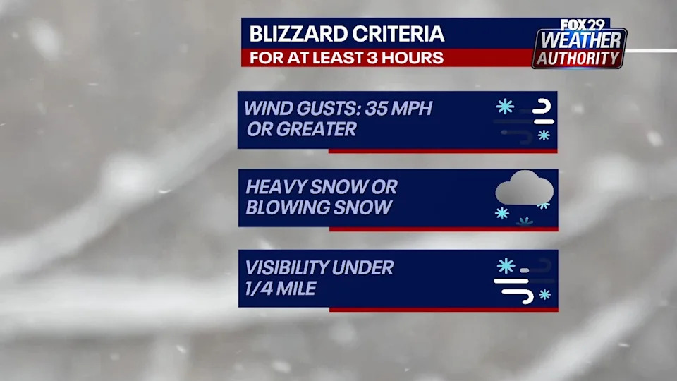
Winter storm warnings are in effect for the rest of the area through Monday.
FIND THE LATEST WINTER WEATHER FORECAST HERE
Those warnings remain as strong winds are expected to continue throughout the day, creating coastal flooding, power outages, and drifting snow concerns.
Coastal flooding concerns
Widespread minor tidal flooding is expected for the Atlantic Coast and Delaware Bay with the mid day high tide. Localized areas of moderate tidal flooding will be possible along the back bays.
The greatest threat will be centered around the high tide which occurs on the oceanfront between 11 a.m. and 1 p.m. Monday.
Track live storm updates
Get the latest storm updates and information from FOX 29 by clicking here.
Stay ahead of the snow with FOX 29’s expert meteorologists on FOX LOCAL. Get the latest on the forecast, snow potential, and preparation tips. Download FOX LOCAL for 24/7 weather coverage on your smart TV and mobile devices.