For the Lehigh Valley, the Poconos, Berks and Schuylkill counties, and far northwestern New Jersey, we spent the last 24 hours on the edge of a powerful blizzard along the East Coast. For most of us, we were on the outside of that blizzard, looking in, with a general 3 to 8 inches of snow for many. But a mere 50 plus miles to our south and east, a blizzard was raging, with 1 to 2 feet of snow widespread across most of New Jersey, the Delaware Valley, and then into New York City and southeastern New England.
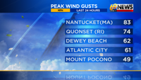
Some spots will likely top with 30 inches or more of snow, and winds gusted anywhere from 50 to 80 miles-per-hour along the coasts from New Jersey to New England.
So while it’s a historic blizzard just to our east, for most of our area, it was a light to moderate snow, with brisk winds that led to a few power outages and some blowing snow into the day on Monday.

Essentially, it snowed so hard over parts of New Jersey that it led to sinking air and much lighter snow west into our corner of Pennsylvania, as the New Jersey snow bands “robbed” areas farther west.
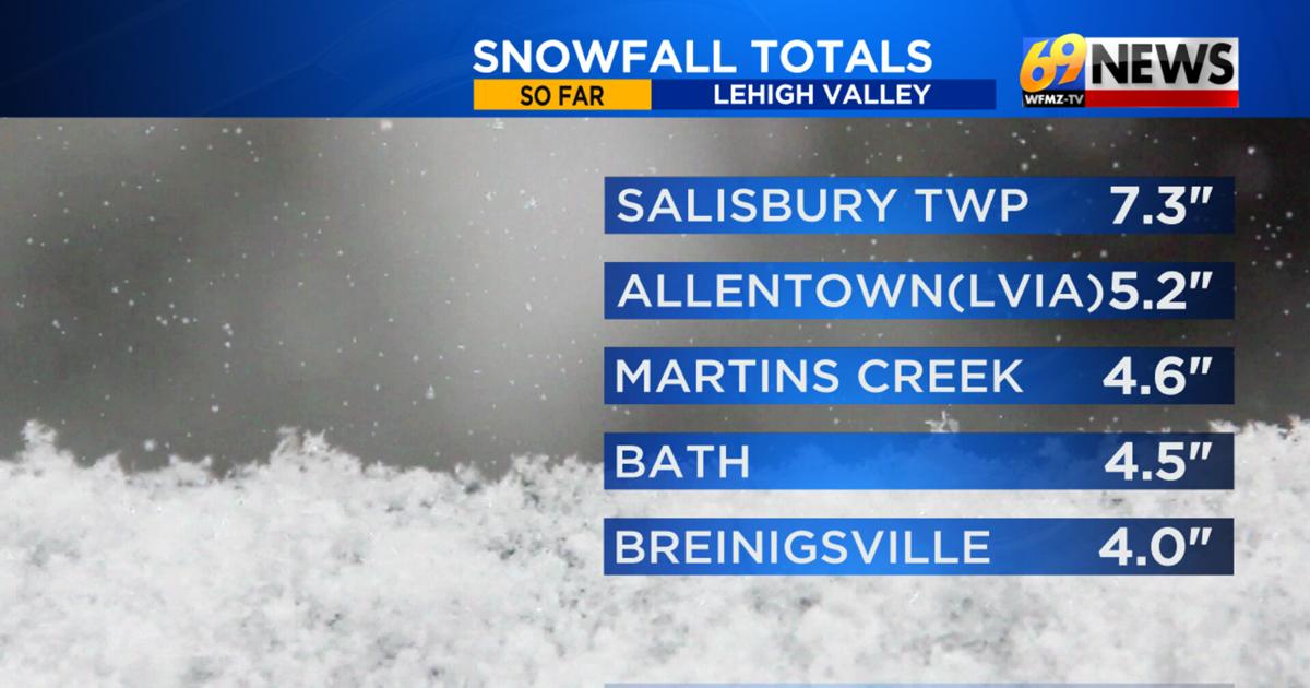
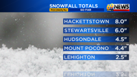
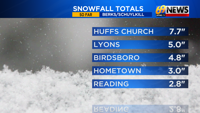
Our weather team did lower our forecast expectations with this storm to 4 to 8 inches for most of our area on Sunday before the storm arrived, acknowledging the increasing chance that the New Jersey banding would lead to noticeably lower totals over the heart of our forecast area. For many spots, 3 to 7 inches of snow was the result, with the lowest totals farther west over Berks and Schuylkill counties, and the highest totals of 7 to 9 inches either in the higher elevations (Huffs Church in Berks, Salisbury Twp. (South Mountain) in Lehigh) or across upper Bucks and Montgomery counties, closer to the heavier bands.
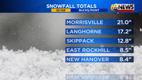
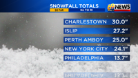
Amounts ballooned to as much as 22″ of snow in parts of Lower Bucks County and those intense snow bands.
While there was some slick travel Sunday night into early Monday morning, it goes without saying that our area dodged the blizzard bullet, as things would have been much different if our low pressure tracked just 50 to 75 miles farther west than what it did.
Who’s ready for spring?? It officially begins in 25 days! Yet while there are no big winter storms in sight, there are a few more chances for at least a little snow in the forecast through early next week.