
A warming trend takes over through the start of the weekend.Mild temps into SaturdayHighs will return to 50 on Friday and the middle 50s on Saturday as clouds increase.Cooler air will start to filter in Saturday night ahead of the start of March.Messy start to next weekAnother round of chilly air to end the weekend. Sunday’s high will be in the 30s. Sunday morning will see a weak system approach from the north. This may touch off a few flurries to light snow showers before sunrise, but little to no accumulation is expected. We are tracking precipitation for Monday and Tuesday. Back-to-back systems are possible with periods of rain and snow. Monday will see snow showers as a system rides down the Ohio River Valley. Recent trends are pushing this system farther south, which means less total storm accumulation and the chance that the system could dive south of us entirely.Tuesday’s system will likely arrive later in the day and last into early Wednesday. If the later timing holds, this could bring all rain to Western PA as it passes. If not, a wintry mix to start will happen before temperatures warm and we transition to rain.A few more chances at rain will be with us before we close out the week. Temperatures will warm through the rest of the week with the 60s returning late next week.TONIGHT: Mainly clear. Low: 26°.FRIDAY: Warmer with sunshine. High: 54°, low: 38°.SATURDAY: Partly cloudy. High: 57°, low: 29°.SUNDAY: Morning flurries then mostly cloudy. High: 38°, low: 22°.
PITTSBURGH —
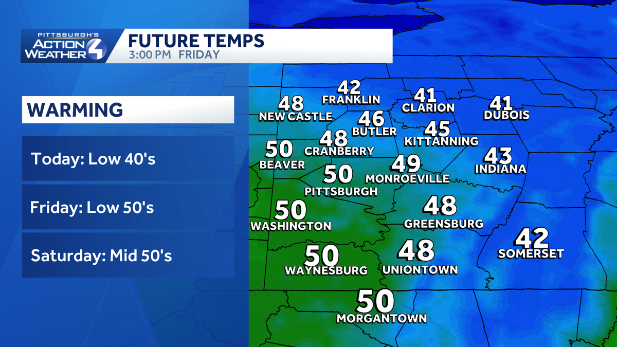
A warming trend takes over through the start of the weekend.
Mild temps into Saturday
Highs will return to 50 on Friday and the middle 50s on Saturday as clouds increase.

Hearst Ownedwtae, ashley dougherty
Cooler air will start to filter in Saturday night ahead of the start of March.
Messy start to next week
Another round of chilly air to end the weekend. Sunday’s high will be in the 30s.
Sunday morning will see a weak system approach from the north. This may touch off a few flurries to light snow showers before sunrise, but little to no accumulation is expected.
We are tracking precipitation for Monday and Tuesday. Back-to-back systems are possible with periods of rain and snow. Monday will see snow showers as a system rides down the Ohio River Valley. Recent trends are pushing this system farther south, which means less total storm accumulation and the chance that the system could dive south of us entirely.

Hearst Owned
Snow showers look to return Monday, but we are watching the track of this system.
Tuesday’s system will likely arrive later in the day and last into early Wednesday. If the later timing holds, this could bring all rain to Western PA as it passes. If not, a wintry mix to start will happen before temperatures warm and we transition to rain.
A few more chances at rain will be with us before we close out the week. Temperatures will warm through the rest of the week with the 60s returning late next week.

Hearst Owned
Warm and sunny weekend with rain and snow to start March.
TONIGHT: Mainly clear. Low: 26°.
FRIDAY: Warmer with sunshine. High: 54°, low: 38°.
SATURDAY: Partly cloudy. High: 57°, low: 29°.
SUNDAY: Morning flurries then mostly cloudy. High: 38°, low: 22°.