
Plentiful sunshine today, soaring to the mid-50s Saturday across south-central Pennsylvania
Although temperatures are trending milder, highs in the 30s are back early next week. We’re tracking an unsettled pattern over the next several days with more chances for rain and snow.
SEVENTH. NOW, THE WGAL NEWS EIGHT STORM TEAM FORECAST WITH METEOROLOGIST RYAN ARGENTE. BRIGHT BLUE SKIES. THAT’S ALL THANKS TO HIGH PRESSURE SETTLED IN OVER THE AREA. YOU CAN SEE EARLIER, THOUGH, WE DID HAVE SOME DENSE FOG IN MOST AREAS. HAD SOME DENSE FREEZING FOG WAS THE CASE. WE HAD. YOU PROBABLY WOKE UP TO SOME FROST, OR AT LEAST WHEN YOU’RE GOING ON YOUR MORNING COMMUTE THIS MORNING, YOU DEFINITELY SAW SOME FROST ON THE WINDSHIELD, BUT TEMPERATURES HAVE NOW RISEN TO RIGHT AROUND 47 DEGREES IN LEBANON. AT THIS TIME, WE’RE GOING TO CONTINUE TO SEE MILDER CONDITIONS DEVELOP THROUGH THE DAY TODAY. ALSO, GETTING INTO OUR SATURDAY, MORE SUNSHINE. SO IT’S NICE TO GET A BREAK FROM SOME OF THE CLOUDY WEATHER, BUT WE ARE GOING TO BE GOING BACK TO THAT CLOUDY WEATHER. UNFORTUNATELY, WE ARE LOOKING AT A COLD AND WET START TO THE WEEK NEXT WEEK. WE DO HAVE A CHANCE FOR SOME LIGHT SNOW, WINTRY MIX AND SOME RAIN. WE’LL CHAT ABOUT THAT HERE IN JUST A COUPLE OF MINUTES, BUT IT WILL BE A WARMER AND WET END TO NEXT WEEK WITH HIGHS INTO THE 50S AND POTENTIALLY THE 60S, WHICH I’LL SHOW YOU IN THE TEN DAY FORECAST. BUT WE DO HAVE CHANCES FOR FOR FOR SEVERAL ROUNDS OF SOME RAIN. SO FOR THIS AFTERNOON EXPECT MILDER CONDITIONS, MOSTLY SUNNY SKIES, 48 DEGREES GOING DOWN TO THE LOWER 40S FOR THIS EVENING UNDER CLEAR SKIES WITH LIGHT WINDS AND THEN BOTTOMING OUT RIGHT AROUND 32 DEGREES FOR OVERNIGHT TONIGHT UNDER MOSTLY CLEAR CONDITIONS. SO NOT AS COLD THOUGH. I’LL MAKE A NOTE FOR OVERNIGHT TONIGHT. AS YOU CAN SEE, MILDER CONDITIONS ALREADY SETTING IN 42 DEGREES IN HARRISBURG, 45 IN CARLISLE, 45 IN LEWISTOWN AT THIS TIME. GOT A CALM. IT’S A LIGHT SOUTHERLY WIND RIGHT NOW BETWEEN 5 AND 10MPH. YOU CAN SEE STORM TEAM LIVE RADAR NETWORK. ALL IS CLEAR RIGHT NOW. JUST SOME HIGH LEVEL CLOUDS THAT ARE JUST PASSING BY. AND THAT’S ALL THANKS TO HIGH PRESSURE THAT’S SETTLED IN. AND IT’S HELPING TO FEED IN SOME MILDER AIR FROM THE SOUTH. NOW HIGH PRESSURE WILL SWITCH BACK DOWN TOWARDS THE SOUTH AS WE GET INTO THE FIRST HALF OF THE WEEKEND. STILL LOOKING AT SOME MOSTLY SUNNY CONDITIONS, BUT WE’LL BEGIN TO WILL WE’LL TREND UP IN TERMS OF MILDER WEATHER THROUGH THE 50S FOR TOMORROW. NOW, AS WE HAVE A COLD FRONT THAT’S MOVING INTO THE COMMONWEALTH, THIS HERE COMES OUR SUNDAY. THAT’S GOING TO ALLOW THE CHANCE FOR SOME SOME POSSIBLE LIGHT SNOW SHOWERS AS WE GET INTO OUR SUNDAY. BUT IT WILL BE QUICK MOVING SNOW SHOWERS, NOT REALLY EXPECTING MUCH ACCUMULATION AT ALL WITH THIS SUNDAY COLD FRONT THAT’S GOING TO MOVE THROUGH. NOW LOOKING AHEAD THOUGH, WE ARE LOOKING AT A COUPLE OF STORMS FOR THE BEGINNING OF THE WORKWEEK. LET’S START OFF WITH OUR MONDAY. YOU CAN SEE IN TERMS OF THE MODEL GUIDANCE, THIS STORM SYSTEM, THIS FIRST STORM SYSTEM IS REMAINING TOWARDS OUR SOUTH. ONLY REALLY THINKING THAT THERE’S GOING TO BE A VERY SLIGHT CHANCE OF SOME SNOW SHOWERS FOR OUR MONDAY. HOWEVER, I WILL SAY THE SECOND STORM SYSTEM FOR TUESDAY. WE HAVE A BETTER CHANCE OF SEEING A MIX OF SOME SNOW, POSSIBLY SOME POSSIBLY FREEZING RAIN, OR A MIX OF SOME RAIN AND SOME SNOW. SO THIS IS WHAT WE’RE SEEING IN TERMS OF THE OF WHAT WE’RE BEING HINTED. AND THEN WE’RE LOOKING AT CHANGING OVER TO ALL RAIN BY THE TIME WE GET TO OUR TUESDAY. SO TIMING TEMPERATURES, THE TYPE OF PRECIPITATION STILL TO BE DETERMINED AS WE GET INTO OUR TUESDAY. SO YOU CAN SEE THAT’S REFLECTED IN OUR TEN DAY FORECAST. CHANCE FOR SHOWERS AS WE GET INTO OUR WEDNESDAY, THURSDA
Plentiful sunshine today, soaring to the mid-50s Saturday across south-central Pennsylvania
Although temperatures are trending milder, highs in the 30s are back early next week. We’re tracking an unsettled pattern over the next several days with more chances for rain and snow.

Updated: 12:23 PM EST Feb 27, 2026
High pressure will deliver plentiful sunshine and highs in the upper 40s to near 50 degrees today. Winds will be light.Tonight, lows will fall to 32 degrees under mostly clear skies.The last day of February looks dry and milder. Highs will soar to the mid-50s Saturday under mostly sunny skies. The last time highs hit 50 in Harrisburg was on January 13 (51°).As a cold front approaches Sunday morning, scattered rain and snow showers are possible. Temperatures should be at or above freezing, so travel impacts will be minimal. A coating is possible in the grass. Look for gradual clearing Sunday afternoon and highs in the low 40s.We’re watching a chance of light snow or snow showers Monday afternoon and evening. Potential snowfall accumulations look light, with temperatures peaking around 32 degrees.Then, another system will bring brief snow, to wintry mix, to rain Tuesday morning into the afternoon, with highs in the mid-30s. We’ll fine-tune precipitation type and what to expect hour-by-hour in the coming days.Temperatures trend milder, in the 40s, Wednesday and Thursday, and could reach the mid 50s Friday and Saturday.Rain showers are possible Wednesday through Saturday at times, as a series of fronts move across the area. With warmer temperatures, all rain is expected out of these systems. The rain will also be beneficial for the prolonged drought conditions we’ve been facing since last fall.
High pressure will deliver plentiful sunshine and highs in the upper 40s to near 50 degrees today. Winds will be light.
Tonight, lows will fall to 32 degrees under mostly clear skies.
The last day of February looks dry and milder. Highs will soar to the mid-50s Saturday under mostly sunny skies. The last time highs hit 50 in Harrisburg was on January 13 (51°).
As a cold front approaches Sunday morning, scattered rain and snow showers are possible. Temperatures should be at or above freezing, so travel impacts will be minimal. A coating is possible in the grass. Look for gradual clearing Sunday afternoon and highs in the low 40s.
We’re watching a chance of light snow or snow showers Monday afternoon and evening. Potential snowfall accumulations look light, with temperatures peaking around 32 degrees.
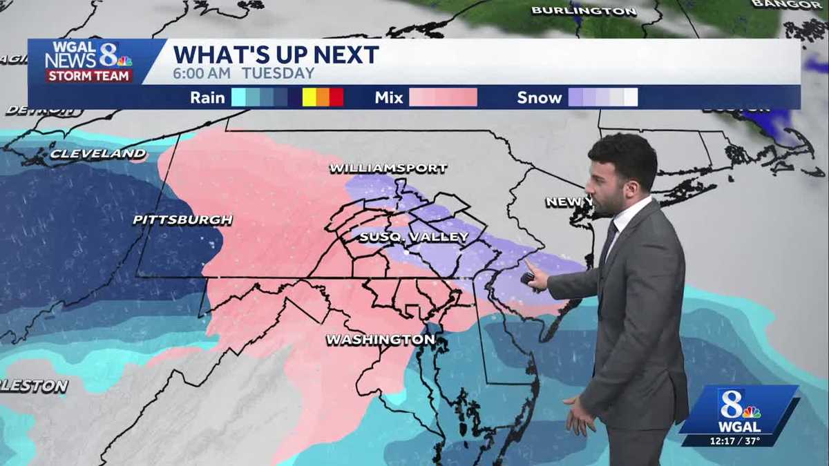
Then, another system will bring brief snow, to wintry mix, to rain Tuesday morning into the afternoon, with highs in the mid-30s. We’ll fine-tune precipitation type and what to expect hour-by-hour in the coming days.
Temperatures trend milder, in the 40s, Wednesday and Thursday, and could reach the mid 50s Friday and Saturday.
Rain showers are possible Wednesday through Saturday at times, as a series of fronts move across the area. With warmer temperatures, all rain is expected out of these systems. The rain will also be beneficial for the prolonged drought conditions we’ve been facing since last fall.