
Sunny & warm start to the weekend; rain/snow chances Sunday into next week across south-central Pennsylvania
Although temperatures are trending milder, highs in the 30s are back early next week. We’re tracking an unsettled pattern over the next several days with more chances for rain and snow.
MOON. THE MOON LANDING MISSION IS SLATED FOR 2028. NOW, THE WGAL NEWS EIGHT STORM TEAM FORECAST, WITH METEOROLOGIST RYAN ARGENTE. ENJOY THE DRY AND PLEASANT CONDITIONS FOR THE DAY TODAY. IT WILL BE WARMER, MORE SUNSHINE AS WE HEAD INTO THE FIRST HALF OF THE WEEKEND. COULD COULD BE CLOSER TO 60 DEGREES FOR SATURDAY, BUT THEN IT WILL BE COLD AND WET TO OR FOR THE START OF NEXT WEEK, WITH CHANCES FOR LIGHT SNOW, WINTRY MIX, POSSIBLY SOME RAIN FOR NEXT WEEK. BUT WE’RE ALSO GOING TO BE LOOKING AT A WARMER AND WET END TO NEXT WEEK, WITH HIGHS INTO THE 50S INTO THE 60S, WITH MORE CHANCES FOR ROUNDS OF SOME RAIN. SO WEATHER PLANNER FOR THIS EVENING. EXPECT MAINLY CLEAR CONDITIONS WITH LIGHT WINDS WILL BE COOLER CLOSER TO 40 DEGREES LATER ON THIS EVENING. 32 FOR TONIGHT. MOSTLY CLEAR, NOT AS COLD. MOSTLY SUNNY FOR TOMORROW, RIGHT AROUND 58 DEGREES. COULD CHALLENGE THAT. COULD GET TO THAT 60 DEGREE MARK FOR THE AFTERNOON AND WARM AND PLEASANT FOR FOR TOMORROW. SO FOR YORK RESTAURANT WEEK, BY THE WAY, THAT’S RUNNING THROUGH SUNDAY FOR THE AFTERNOON. MOSTLY SUNNY, GETTING UP TOWARDS THE 50S BY THE MIDDLE OF THE AFTERNOON, GETTING INTO THE EARLY EVENING AND 46 DEGREES BY THE TIME WE GET TO ABOUT 8:00 IN THE EVENING WITH PARTLY CLOUDY CONDITIONS. NOW, IN TERMS OF THE HIGH TEMPERATURE TREND FOR THIS WEEK, LOOK AT THIS. IT’S A BIT OF A WAVY PATTERN. SO WE GOT 50. WE GOT UPPER 50S FOR SATURDAY DROPPING DOWN TO THE 40S FOR SUNDAY. THEN BACK TO THAT FREEZING MARK FOR OUR MONDAY AND 30S AGAIN FOR TUESDAY. BUT WE ARE TRENDING BACK UPWARDS ONCE WE GET INTO OUR WEDNESDAY, WHICH ALSO TRENDING UP FOR SOME OF THESE RAINFALL CHANCES. YOU CAN SEE THE PRECIPITATION CHANCES FOR SUNDAY THROUGH WEDNESDAY OF NEXT WEEK. MORE SO THURSDAY AND FRIDAY. SO THERE’S A CHANCE OF SOME SHOWERS EVERY DAY AS WE GET INTO NEXT WEEK. SO TEMPERATURES THOUGH INTO THE 50S 51 IN LANCASTER, 55 IN GETTYSBURG, 54 LEWISTOWN AND 50 DEGREES IN THE CAPITAL AT THIS TIME. WE GOT WINDS RIGHT NOW OUT OF THE SOUTH BETWEEN 5 AND 10MPH. GOT A 12 MILE PER HOUR BREEZE IN LEBANON RIGHT NOW, TEN MILE PER HOUR BREEZE IN SELINSGROVE, BUT MOSTLY CLEAR CONDITIONS ON STORM TEAM LIVE RADAR NETWORK. JUST ENJOYING THE INFLUENCE OF HIGH PRESSURE SETTLED IN OVERHEAD AND WITH THAT HIGH PRESSURE SETTLED IN, THAT’S WHAT’S HELPING TO FEED IN SOME OF THAT MILDER AIR FROM THE SOUTH. NOW, HIGH PRESSURE WILL CONTINUE TO SCOOTCH TO THE SOUTH. IT WILL STILL BE CLOSE ENOUGH TO THE SUSQUEHANNA VALLEY OR TO TO TO THE COMMONWEALTH TO ALLOW FOR SOME MAINLY, MOSTLY SUNNY CONDITIONS FOR OUR SATURDAY. THEN HERE COMES SUNDAY. WE HAVE A COLD FRONT THAT’S GOING TO START TO DIP THROUGH, AND YOU CAN SEE THE COLD FRONT STARTS TO MOVE THROUGH AND ALLOWS A CHANCE FOR THERE TO BE SOME SOME SNOW. ALSO COULD SEE A MIX. THIS IS PREDICTORS INDICATING THAT WE COULD SEE A MIX. MAYBE SOME RAIN POSSIBLY. BUT IT LOOKS LIKE THE MAIN TYPE OF PRECIPITATION IS SNOW AND NOT REALLY EXPECTING A LOT OUT OF THIS COLD FRONT AS IT PASSES BY. IN TERMS OF THE SNOWFALL ACCUMULATION. THEN FOR SUNDAY, LOOKING MAINLY CLEAR. AND THEN ONCE WE AND HERE’S HERE’S THE IN TERMS OF THE SNOWFALL AMOUNTS ABOUT A COATING TO ONE INCH IS ALL WE’RE EXPECTING. YOU CAN SEE MAINLY COMMUNITIES NORTH AND WEST OF I-81. COULD SEE THAT BEST CHANCE FOR SEEING THAT COATING TO ONE INCH. SO KEEP THAT IN MIND. AND OTHER COMMUNITIES SOUTH AND EAST OF I-81 ARE REALLY LOOKING AT MUCH. SO LET’S TALK ABOUT MONDAY BECAUSE IT’S A BIT OF AN UNSETTLED PATTERN. SO WE’RE GOING TO CHAT ABOUT THE BEGINNING OF THE WORKWEEK IN TERMS OF THE CHANCES FOR PRECIPITATION. THEY ARE GOING LOWER FROM WHAT WE’RE SEEING IN THE MODEL GUIDANCE. HOWEVER DAY TWO OR THE STORM TWO THAT WE’RE GOING TO BE WATCHING FOR OUR TUESDAY IS SUGGESTING WE COULD BE SEEING A MIX OF SOME SNOW, SOME SLEET, POSSIBLY SOME FREEZING RAIN OR JUST PLAIN RAIN. SO THERE’S THERE’S SOME THINGS THAT WE’RE TRYING TO FIGURE OUT RIGHT NOW, THINGS THAT ARE TO BE DETERMINED IN TERMS OF THE TIMING, THE TEMPERATURES, THE TYPE OF PRECIPITATION AND THE TOTALS. BUT THERE ARE A COUPLE CHANCES FOR WINTRY WEATHER HEADING INTO NEXT WEEK. BUT YOU CAN SEE THAT’S REFLECTED IN OUR TEN DAY FORECAST. TEMPERATURES INTO THE 30S. THEN WE GET INTO THAT MODERATING TREND TO THE MID TO UPPER 40S BY WEDNESDAY AND THURSDAY, 50 F
Sunny & warm start to the weekend; rain/snow chances Sunday into next week across south-central Pennsylvania
Although temperatures are trending milder, highs in the 30s are back early next week. We’re tracking an unsettled pattern over the next several days with more chances for rain and snow.

Updated: 4:54 PM EST Feb 27, 2026
Expect high pressure to continue influencing our conditions with mainly clear skies and light winds. Temperatures will hover in the lower 40sTonight, lows will fall to 32 degrees under mostly clear skies & it won’t feel as cold. Patchy fog is possible overnight.The last day of February looks dry and milder. Highs will soar to the mid-50s Saturday under mostly sunny skies. The last time highs hit 50 in Harrisburg was on January 13 (51°).As a cold front approaches Sunday morning, scattered rain and snow showers are possible. Temperatures should be at or above freezing, so travel impacts will be minimal. A coating is possible in the grass. Look for gradual clearing Sunday afternoon and highs in the low 40s.We’re watching a chance of light snow or snow showers Monday afternoon and evening. Potential snowfall accumulations look light, with temperatures peaking around 32 degrees.Then, another system will bring brief snow, to wintry mix, to rain Tuesday morning into the afternoon, with highs in the mid-30s. We’ll fine-tune precipitation type and what to expect hour-by-hour in the coming days.Temperatures trend milder, in the 40s, Wednesday and Thursday, and could reach the mid 50s Friday and Saturday.Rain showers are possible Wednesday through Saturday at times, as a series of fronts move across the area. With warmer temperatures, all rain is expected out of these systems. The rain will also be beneficial for the prolonged drought conditions we’ve been facing since last fall.
Expect high pressure to continue influencing our conditions with mainly clear skies and light winds. Temperatures will hover in the lower 40s
Tonight, lows will fall to 32 degrees under mostly clear skies & it won’t feel as cold. Patchy fog is possible overnight.
The last day of February looks dry and milder. Highs will soar to the mid-50s Saturday under mostly sunny skies. The last time highs hit 50 in Harrisburg was on January 13 (51°).
As a cold front approaches Sunday morning, scattered rain and snow showers are possible. Temperatures should be at or above freezing, so travel impacts will be minimal. A coating is possible in the grass. Look for gradual clearing Sunday afternoon and highs in the low 40s.
We’re watching a chance of light snow or snow showers Monday afternoon and evening. Potential snowfall accumulations look light, with temperatures peaking around 32 degrees.
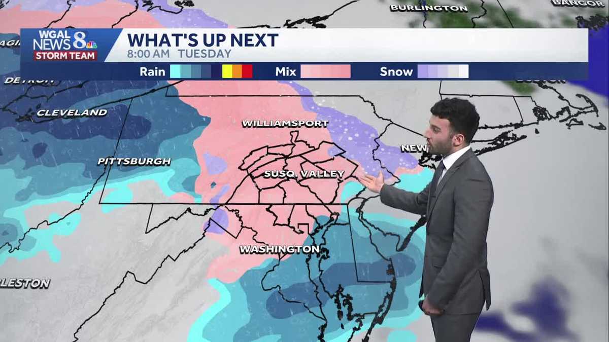
Then, another system will bring brief snow, to wintry mix, to rain Tuesday morning into the afternoon, with highs in the mid-30s. We’ll fine-tune precipitation type and what to expect hour-by-hour in the coming days.
Temperatures trend milder, in the 40s, Wednesday and Thursday, and could reach the mid 50s Friday and Saturday.
Rain showers are possible Wednesday through Saturday at times, as a series of fronts move across the area. With warmer temperatures, all rain is expected out of these systems. The rain will also be beneficial for the prolonged drought conditions we’ve been facing since last fall.