
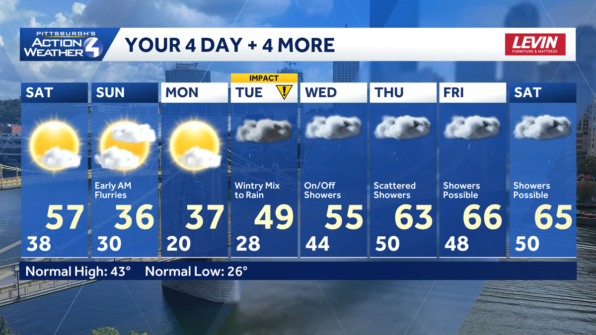
Warmer with sunshine today…colder on Sunday with isolated AM snowflakes. Mild temps into SaturdayHighs will return to the middle/upper 50’s on Saturday.Cold air will start to filter in Saturday night ahead of the start of March.Messy start to next weekAnother round of chilly air to end the weekend. Sunday’s high will be in the 30s.Sunday morning will see a weak system approach from the north. This may touch off a few flurries to light snow showers before sunrise, but little accumulation is expected. Locations in and south of Pittsburgh could see a few sprinkles early. Everything should end by 9 a.m.We are tracking precipitation for Monday and Tuesday. Back-to-back systems are possible with periods of snow, then rain. Monday is looking dry with a series of mainly rain showers starting Tuesday.Tuesday’s system will arrive prior to sunrise. There is the chance that locations east of Pittsburgh especially could start off with a wintry mix. Everything will transition to rain through the morning with rain showers through the day.A few more chances at rain will be with us before we close out the week. Temperatures will warm through the rest of the week with the 60s returning late next week.TODAY: Mostly sunny High: 57°TONIGHT: Increasing clouds, isolated flurries/light rain late. Low 30°SUNDAY: Morning flurries and sprinkles. Becoming partly cloudy. High: 38°, low:
Warmer with sunshine today…colder on Sunday with isolated AM snowflakes.
Mild temps into Saturday
Highs will return to the middle/upper 50’s on Saturday.

Cold air will start to filter in Saturday night ahead of the start of March.
Messy start to next week
Another round of chilly air to end the weekend. Sunday’s high will be in the 30s.
Sunday morning will see a weak system approach from the north. This may touch off a few flurries to light snow showers before sunrise, but little accumulation is expected. Locations in and south of Pittsburgh could see a few sprinkles early. Everything should end by 9 a.m.
We are tracking precipitation for Monday and Tuesday. Back-to-back systems are possible with periods of snow, then rain. Monday is looking dry with a series of mainly rain showers starting Tuesday.

Tuesday’s system will arrive prior to sunrise. There is the chance that locations east of Pittsburgh especially could start off with a wintry mix. Everything will transition to rain through the morning with rain showers through the day.
A few more chances at rain will be with us before we close out the week. Temperatures will warm through the rest of the week with the 60s returning late next week.

TODAY: Mostly sunny High: 57°
TONIGHT: Increasing clouds, isolated flurries/light rain late. Low 30°
SUNDAY: Morning flurries and sprinkles. Becoming partly cloudy. High: 38°, low: