
Skies will clear through the day on Sunday, but we remain chilly as we stay in the 30s. Monday will be dry and seasonal with partly cloudy skies. An active week of precipitation lies ahead with an Impact Day on Tuesday.Impact Day Tuesday A system that passes to our south on Monday will start to lift north Tuesday morning into Western PA. As it does, precipitation could start as freezing rain. This will be temperature dependent as we need to be below freezing and temperatures will be warming as precipitation arrives. As of now, the best chances to see freezing rain will be the Laurel Highlands and north of I-80 through the morning.Freezing rain totals should generally only be a light glaze before we transition to all rain. Rain will last through the entirety of our Tuesday and into Wednesday morning.Soggy Week AheadEach day from Tuesday through Saturday will feature the chance to see rain showers. The best chance of rain will be Tuesday. Scattered showers will be around Wednesday and Thursday. Friday and Saturday could both feature better chances at rain and perhaps even a thunderstorm as temperatures warm to near 70° for the first time this year.TODAY: Turning partly cloudy. High: 36°.TONIGHT: Mainly clear. Low: 20°.MONDAY: Partly cloudy and seasonal. High: 42°, low: 30°.TUESDAY – IMPACT DAY: Morning wintry mix north and east of Pittsburgh. Rain through the day. High: 52°, low: 44°.
PITTSBURGH —
Skies will clear through the day on Sunday, but we remain chilly as we stay in the 30s. Monday will be dry and seasonal with partly cloudy skies. An active week of precipitation lies ahead with an Impact Day on Tuesday.
Impact Day Tuesday
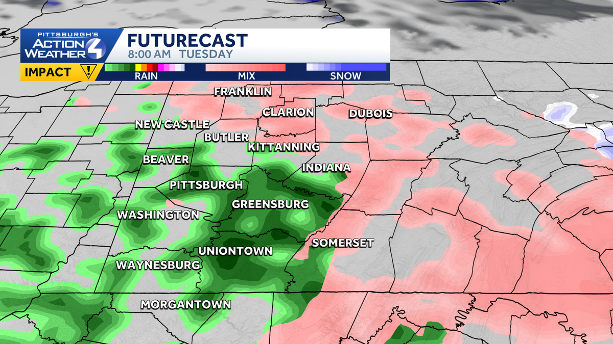
A system that passes to our south on Monday will start to lift north Tuesday morning into Western PA. As it does, precipitation could start as freezing rain. This will be temperature dependent as we need to be below freezing and temperatures will be warming as precipitation arrives. As of now, the best chances to see freezing rain will be the Laurel Highlands and north of I-80 through the morning.

Hearst Owned
Freezing rain is possible as we start Tuesday. The best chances to see freezing rain are the Laurel Highlands and north of Interstate 80.
Freezing rain totals should generally only be a light glaze before we transition to all rain. Rain will last through the entirety of our Tuesday and into Wednesday morning.

Hearst Owned
While freezing rain is expected Tuesday morning, significant icing is not.
Soggy Week Ahead
Each day from Tuesday through Saturday will feature the chance to see rain showers. The best chance of rain will be Tuesday. Scattered showers will be around Wednesday and Thursday. Friday and Saturday could both feature better chances at rain and perhaps even a thunderstorm as temperatures warm to near 70° for the first time this year.

Hearst Owned
Temperatures warm through the week with rain chances almost each day. Tuesday could start with freezing rain, prompting an Impact Day.
TODAY: Turning partly cloudy. High: 36°.
TONIGHT: Mainly clear. Low: 20°.
MONDAY: Partly cloudy and seasonal. High: 42°, low: 30°.
TUESDAY – IMPACT DAY: Morning wintry mix north and east of Pittsburgh. Rain through the day. High: 52°, low: 44°.