
Rain Settles into Western PA this Week
SPRINGTIME VARIETY PACK OF WEATHER. LET’S CHECK IN WITH ASHLEY DOUGHERTY. IT IS JUST, YOU KNOW, WE’RE COLD. WE GOT SOME SNOWFLAKES TODAY. THEN WE GOT AN IMPACT DAY TOMORROW WITH POTENTIAL FOR SOME FREEZING RAIN HITTING NOT JUST EAST, BUT ALSO IN PARTS OF ALLEGHENY COUNTY BEFORE CHANGING OVER TO HEAVIER RAIN. WE DO WARM UP THOUGH. UPPER 60S, LOW 70S TO FINISH OUT THE WEEK, BUT IT IS GOING TO BE A SOGGY WEEK AHEAD. THIS IS GOING UNTIL SATURDAY AT 11:00. YOU CAN SEE THE RANGE HERE ABOUT ONE TO ALMOST FOUR INCHES OF RAINFALL THROUGHOUT THE WEEK. THAT IS A LOT OF RAIN. NOW IT DOES LOOK LIKE WEDNESDAY WILL BE OUR BEST DAY RIGHT NOW TO SEE SOME DRIER CONDITIONS, BUT IT IS SHORT LIVED. LET’S GET TO IT. RIGHT NOW WE’RE SEEING SOME LIGHT SNOW SHOWERS HITTING SOUTHERN PORTIONS OF FAYETTE AND GREENE DOWN INTO MORGANTOWN. LIGHT ACCUMULATIONS ARE EXPECTED, BUT I DO THINK THIS IS GOING TO TICK UP INTO PARTS OF WASHINGTON, EVEN NEAR THE ELIZABETH AREA. THE THING IS, WE HAVE HIGH PRESSURE SITTING JUST NORTH OF US. THAT’S WHAT’S KEEPING A LOT OF THIS SOUTH AND ALSO DRYING UP, PUSHING IN SOME OF THAT DRIER AIR. BUT I DO THINK SOME OF THAT MOISTURE IS GOING TO CONTINUE TO DEVELOP AND MOVE IN. AND YOU CAN SEE THIS HERE ON FUTURECAST STILL AROUND LUNCHTIME, COULD SEE THAT LIGHT SNOW, BUT CLOUDS WILL BE BREAKING AND WE WILL SEE SOME SUNSHINE THE FURTHER NORTH YOU LIVE, INCLUDING BUTLER, LAWRENCE CLARION ARMSTRONG, YOU HAVE MORE SUNSHINE. HERE’S WHERE IT CHANGES A BIT GETTING INTO TOMORROW IMPACT DAY WHERE THAT PINK IS. THAT’S AN INDICATOR OF A WINTRY MIX. SOME FREEZING RAIN. NOW IT’S ALL GOING TO BE DEPENDENT ON THE GROUND. TEMPERATURE IS WARM ENOUGH IN THE SKY TO FALL AS RAIN, BUT OVERALL, WE DO HAVE THE POTENTIAL FOR SOME OF THAT FREEZING RAIN BEFORE THE GROUND STARTS TO WARM UP. SO THIS COULD HIT PARTS OF ALLEGHENY. THE BULK OF IT WILL BE EAST IN THOSE HIGHER ELEVATIONS, BUT WE’RE TALKING SIDEWALKS. EVEN YOUR HANDRAILS GETTING DOWN, WALKING DOWN SOME STEPS, ELEVATED SURFACES COULD BE DEALING WITH SOME ICY CONDITIONS. JUST BE PREPARED FOR THAT BY SEVEN 8:00. IT DOES LOOK LIKE WE WILL WARM UP IN A LITTLE BIT LIGHTER WITH THE RAIN. IT RAMPS UP THOUGH AS WE GET AFTER LUNCHTIME. ONE 2:00 AND WE WILL HAVE POCKETS OF HEAVY RAIN FOR THAT EVENING COMMUTE. KEEPING OUR IMPACT DAY THROUGH THE DAY. ON TUESDAY. WEDNESDAY RIGHT NOW DOES LOOK LIKE WE COULD SEE A BREAK FROM THOSE RAIN SHOWERS. WILL BE FINE TUNING IT BEFORE WE SEE MORE RAIN, POTENTIALLY SOME ISOLATED THUNDERSTORMS HEADING INTO THURSDAY. IT’S A LOT TO TAKE IN. WE DO HAVE THAT WINTER WEATHER ADVISORY, THOUGH FOR THE HIGHER ELEVATIONS STARTING AT 10:00 TONIGHT UNTIL 10 A.M. TUESDAY. THAT IS BECAUSE THE POTENTIAL FOR SOME VERY LIGHT ICE ACCUMULATION. WE ARE WARMING UP, SO WE’RE TALKING UPPER 60S, LOW 70S. WE’RE GOING TO HAVE TO KEEP OUR EYE ON THURSDAY WITH THE CHANCE FOR SOME OF THOSE THUNDERSTORMS TO DEVELOP. IT’S PRETTY QUIET DOWNTOWN PITTSBURGH CLOUDS HAVE ALREADY STARTED TO MOVE IN, BUT COLD 19 RIGHT NOW IN PITTSBURGH, 21 WAKING UP IN WASHINGTON AND GREENSBURG, 17 IN BUTLER, 18. KITTANNING, 16, IN NEWCASTLE WILL CLIMB INTO THE LOW 40S AGAIN. WE SHOULD SEE SOME SUNSHINE AS WE GET INTO THE AFTERNOON, BUT ALSO SOME OF THOSE SNOWFLAKES SOUTH OF THE CITY. THIS IS A VERY SPRING LIKE FORECAST. THAT MIX TO RAIN MAKES OUR IMPACT DAY ON TUESDAY. SMALL CHANCE FOR A FEW ISOLATED SHOWERS WEDNESDAY. I THINK IT’S GOING TO BE THE DRIEST DAY OF THE WEEK AS WE LOOK THURSDAY FRIDAY, EVEN EXTENDING INTO SAT
Light snow showers expected South of Pittsburgh this morning and expecting light accumulations. Clouds will decrease through the day to finish out the afternoon with sunshine.Impact Day Tuesday Our next threat for precipitation comes Tuesday with a wintry mix in the higher elevations and scattered rain showers through the day. Everyone will transition to rain by Tuesday afternoon, and some of the heavier, more steady rain comes in the afternoon and through the evening commute. Rain through the Week/WeekendEach day from Tuesday through Sunday will feature the chance to see rain showers. Wednesday may be our driest day of the week, but the rain will linger into the weekend. We will be watching the chance for isolated thunderstorms to pop on Thursday afternoon. Temperatures will be warming through the week with the mercury expected near 70° for the first time this year by Friday.TODAY: AM clouds/ Some PM Sun. High: 42°TONIGHT: Mostly cloudy, wintry mix/rain showers developing. Low 33°TUESDAY – IMPACT DAY: Morning wintry mix, especially north and east. PM rain. High: 52°, low: 44°.
Light snow showers expected South of Pittsburgh this morning and expecting light accumulations. Clouds will decrease through the day to finish out the afternoon with sunshine.

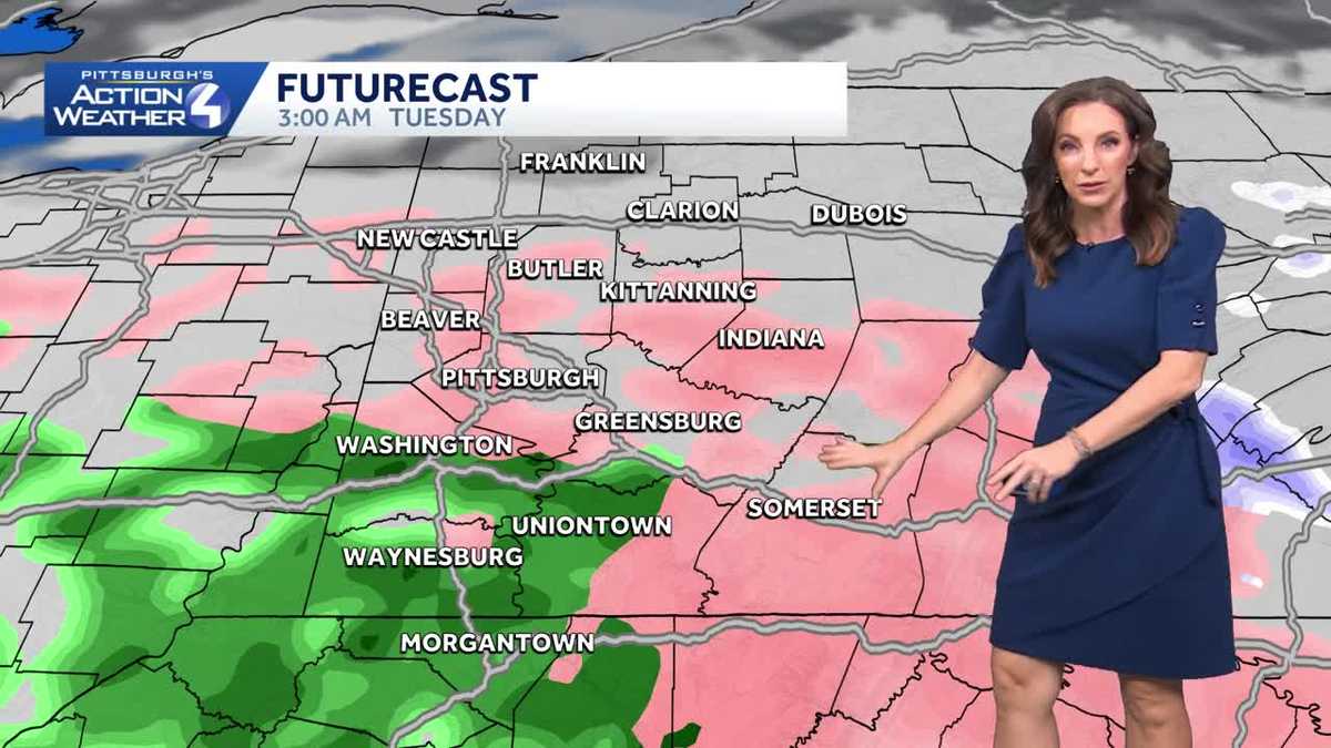
Impact Day Tuesday
Our next threat for precipitation comes Tuesday with a wintry mix in the higher elevations and scattered rain showers through the day.

Everyone will transition to rain by Tuesday afternoon, and some of the heavier, more steady rain comes in the afternoon and through the evening commute.

Rain through the Week/Weekend
Each day from Tuesday through Sunday will feature the chance to see rain showers. Wednesday may be our driest day of the week, but the rain will linger into the weekend. We will be watching the chance for isolated thunderstorms to pop on Thursday afternoon.
Temperatures will be warming through the week with the mercury expected near 70° for the first time this year by Friday.

TODAY: AM clouds/ Some PM Sun. High: 42°
TONIGHT: Mostly cloudy, wintry mix/rain showers developing. Low 33°
TUESDAY – IMPACT DAY: Morning wintry mix, especially north and east. PM rain. High: 52°, low: 44°.