
Hour-by-hour wintry mix projections in south-central Pennsylvania
GOOD MORNING. HERE’S OUR STORM TEAM LIVE RADAR NETWORK. RIGHT NOW YOU CAN SEE WE HAVE A MIXED BAG OF PRECIPITATION. I THINK THIS IS MAINLY FREEZING RAIN. I’M NOT GOING TO RULE OUT A LITTLE BIT OF SNOW OR SOME SLEET MIXING IN, BUT I THINK THIS IS PREDOMINANTLY FREEZING RAIN. WE’VE BEEN SEEING THAT ON OUR SKY CAMS IN GETTYSBURG IN YORK, IN LANCASTER, LEBANON HAS RAINDROPS ON THE LENS. SO PLEASE BE CAUTIOUS BECAUSE LOOK AT THE TEMPERATURES. WE ARE IN THE 20S AND 30S AND THOSE NUMBERS ARE BELOW FREEZING. SO ANYTHING THAT FALLS WILL FREEZE ON CONTACT. THAT IS FREEZING RAIN. WIND SPEEDS THERE OUT OF THE SOUTHEAST AT ABOUT 5 TO 10MPH. JUST ADDING A LITTLE BIT OF A CHILL TO THE AIR, MAKING IT FEEL LIKE THE MID 20S. HERE’S YOUR WEATHER PLANNER. TODAY WE HAVE THAT FREEZING RAIN SLICK ROADS THIS MORNING. I DO THINK AROUND TEN 11:00 MOST SPOTS WILL RISE ABOVE THE FREEZING MARK FOR THE AFTERNOON. WE GET TO 36 WITH RAIN SHOWERS, DAMP AND CHILLY. AND THEN THIS EVENING SOME STEADY RAIN MOVES IN FOR THE EVENING COMMUTE, SO IT’S GOING TO BE A SOGGY ONE, BUT NOT A SLICK ONE LIKE IT WILL BE THIS MORNING. SO PLEAS
Hour-by-hour wintry mix projections in south-central Pennsylvania

Updated: 5:26 AM EST Mar 3, 2026
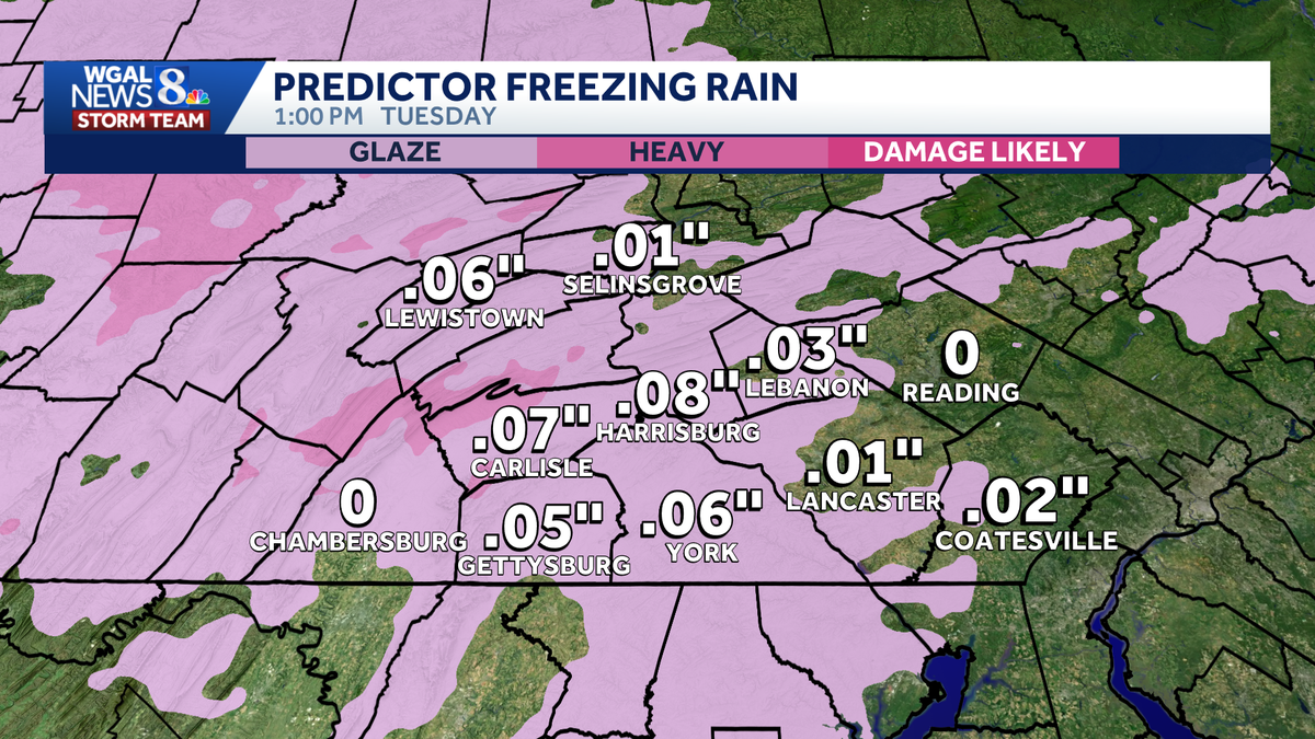
A wintry mix is moving into south-central Pennsylvania, creating slick roads and slowing the Tuesday morning commute. What to knowWinter weather advisory: In effect for the entire Susquehanna Valley until 1 p.m. Impact: The WGAL News 8 Storm Team declared Tuesday an Impact period, also until 1 p.m. Hour-by-hour projectionsEarly morning: Light snow, sleet, and freezing rain develop; Temperatures in the upper 20s to near 30 degrees.Morning commute: Freezing rain is the main precipitation type; Slick roads likely. Late morning to early afternoon: Temperatures rise above freezing from south to north; Freezing rain transitions to plain rain.By around 1 p.m.: Most areas change over to rain.Tuesday afternoon/evening: Periods of light rain continue; Expect a soggy, chilly evening commute. High near 36 degrees.Night: Rain tapers to showers; Temperatures hold near 36 degrees.TotalsSnow: A light coating is possible.Ice: A glaze to less than 0.10 inch of ice is possible from freezing rain. ImpactsLight snow, sleet, and freezing rain are expected to create slick travel conditions.Freezing rain is the main concern, which could glaze ice over roads, especially on bridges, overpasses and untreated roads. Plan for a longer and slower morning commute. Allow extra following distance and go slow. WGAL weather linksWatch it: Use WGAL’s interactive radar to track storms.Get alerts that follow you: Turn on location-based weather alerts with WGAL’s step-by-step instructions.Check what’s closed: See closings and delays for businesses, churches, and organizations during severe weather.Navigate smarter: Open WGAL’s interactive traffic map for crashes, construction, and road closures—with traffic cameras.Inbox updates: Sign up for email alerts, from daily forecasts to severe-weather warnings.Plan by the hour: View the hour-by-hour forecast for your day.Weekend ready: Preview the weekend forecast before you lock in plans.Look ahead: Browse the 10-day forecast for the extended outlook.
A wintry mix is moving into south-central Pennsylvania, creating slick roads and slowing the Tuesday morning commute.
What to know
Winter weather advisory: In effect for the entire Susquehanna Valley until 1 p.m. Impact: The WGAL News 8 Storm Team declared Tuesday an Impact period, also until 1 p.m.

Hour-by-hour projectionsEarly morning: Light snow, sleet, and freezing rain develop; Temperatures in the upper 20s to near 30 degrees.Morning commute: Freezing rain is the main precipitation type; Slick roads likely. Late morning to early afternoon: Temperatures rise above freezing from south to north; Freezing rain transitions to plain rain.By around 1 p.m.: Most areas change over to rain.Tuesday afternoon/evening: Periods of light rain continue; Expect a soggy, chilly evening commute. High near 36 degrees.Night: Rain tapers to showers; Temperatures hold near 36 degrees.
TotalsSnow: A light coating is possible.Ice: A glaze to less than 0.10 inch of ice is possible from freezing rain.


ImpactsLight snow, sleet, and freezing rain are expected to create slick travel conditions.Freezing rain is the main concern, which could glaze ice over roads, especially on bridges, overpasses and untreated roads. Plan for a longer and slower morning commute. Allow extra following distance and go slow.

WGAL weather links