
A series of rain days with an Impact Day on Saturday
A series of rain days with an Impact Day on Saturday
NEWS FOUR ON AIR AND ONLINE FOR THE VERY LATEST. TIME NOW TO CHECK BACK WITH OUR CHIEF METEOROLOGIST, MIKE HARVEY. AND RAIN IS GOING TO BE WITH US FOR A NUMBER OF DAYS NOW. IT CERTAINLY IS TO THE END OF THE WEEK AND INTO THE WEEKEND ON SATURDAY. BUT TEMPERATURES ALSO ON THE WAY UP. THEY WILL BE ON THE RISE. RAIN CHANCES EACH AND EVERY DAY AS WE GO THROUGH THE WEEK INTO SATURDAY. WE DO HAVE A COUPLE DAYS WHERE WE’LL HAVE SOME HEAVY DOWNPOURS. THE POTENTIAL FOR SOME THUNDERSTORMS. THAT WILL BE THURSDAY AS WELL AS SATURDAY, AND TEMPERATURES ON THE WAY TO THE 70S. SO IT IS GOING TO BE QUITE WARM. AND THAT STARTS RIGHT NOW. ACTUALLY, WE’RE SITTING AT 52 DEGREES IN PITTSBURGH. OUR NORMAL HIGH TEMPERATURE 43. SO NEARLY TEN DEGREES ABOVE THAT CURRENTLY 52 IN GREENSBURG AND WASHINGTON, 48 IN WAYNESBURG AND 48 IN BUTLER. CRANBERRY AT 49 DEGREES. WE HAVE THE FOG OUT THERE NOW. FOG INTO TOMORROW MORNING. SO VISIBILITY CERTAINLY COULD BE REDUCED AS YOU’RE HEADING TO WORK TOMORROW. COULD TAKE A COUPLE EXTRA MINUTES TO GET THERE TOMORROW MORNING. A VERY MILD START IN THE MID 40S FOR YOUR LOWS. MID 50S FOR YOUR HIGH TEMPERATURES. NOT A LOT OF RAIN. TOMORROW WE’LL HAVE CLOUDS AROUND. WE’LL HAVE FOG IN THE MORNING, BUT AS FAR AS RAIN SHOWERS, MOST OF THAT IS NOT GOING TO ARRIVE UNTIL WE GET INTO WEDNESDAY NIGHT. HIGH TEMPERATURE ON WEDNESDAY 56 DEGREES, AND ON THURSDAY THAT’S WHEN WE’LL HAVE THE POTENTIAL FOR SHOWERS OFF AND ON THROUGHOUT THE DAY. SOME POCKETS OF HEAVY RAIN OFF AND ON THROUGHOUT THE DAY AND IN THE AFTERNOON. POSSIBILITY OF AN ISOLATED THUNDERSTORM. WARM AT 68 DEGREES. WE TAKE IT TO THE 70S ON FRIDAY AND SATURDAY. RELATIVELY QUIET ON FRIDAY, THEN SATURDAY AGAIN. WE’LL HAVE A CHANCE OF HEAVY DOWNPOURS AS WELL AS THUNDERSTORMS IN THE AFTERNOON. A HIGH OF 74 DEGREES AND IMPACT DAY TO START THE WEEKEND ON SATURDAY. AND THEN WE DRY OUT ON SUNDAY. STILL VERY WARM, 63 DEGREES FOR YOUR HIGH, PARTLY CLOUDY SKIES AND WE KEEP IT WARM INTO NEXT WEEK, WHERE WE RETURN TO THE MID 70S RIGHT NOW. LIGHT RAIN SHOWERS FOR MOST HEAVIER RAIN DOWN TO THE SOUTH IN WEST VIRGINIA. RIGHT NOW YOU CAN SEE MOST OF THAT HEAVY RAIN IS GOING TO STAY SOUTH OF PENNSYLVANIA AND MOVE RIGHT INTO WEST VIRGINIA. AS WE GO THROUGH THE NEXT FEW HOURS, THE OVERNIGHT HOURS, BY TOMORROW, WE COULD HAVE A FEW LIGHT SHOWERS EARLY IN THE DAY. OTHERWISE IT STAYS DRY THROUGH THE REST OF WEDNESDAY UNTIL WE GET INTO WEDNESDAY NIGHT, 910, 11:00. WE’LL HAVE RAIN THAT WILL ARRIVE, AND THAT’S JUST THE START BECAUSE IT WILL CONTINUE AS WE GO THROUGH WEDNESDAY NIGHT AND THROUGH THE DAY ON THURSDAY. HERE’S 4:00 ON THURSDAY IN THE MORNING, AND THEN WE GO TOWARDS NOONTIME, A LITTLE BREAK, AND THEN IT’S RIGHT BACK AT IT WITH WIDESPREAD RAIN, POCKETS OF HEAVY RAIN AS WE GO THROUGH THE DAY ON THURSDAY. AND THEN WE TAKE IT INTO FRIDAY, WHERE WE WILL HAVE A LITTLE BIT OF A BREAK AGAIN. CLOUDS WILL BE WITH US, BUT ONLY ISOLATED SHOWERS ON FRIDAY, SO WE WILL HAVE THE HEAVIEST RAIN AS WE GO THROUGH THURSDAY AND THEN AGAIN ON SATURDAY. SATURDAY
A series of rain days with an Impact Day on Saturday
A series of rain days with an Impact Day on Saturday

Updated: 11:23 PM EST Mar 3, 2026
Rain showers will be possible each day into the weekend.Rain tapers off overnightRainfall overnight with heavier rain, south of Pittsburgh. Rain will slow down after midnight with the only showers left south of Interstate 70 by Wednesday morning.Rain through the Week/WeekendEach day, from Wednesday through Sunday, will feature the chance to see rain showers. Wednesday may be our driest day of the week as rain may hold off until after sunset to return, but the rain will linger into the weekend. We will be watching for rain through the day on Thursday with a chance for isolated thunderstorms to pop up, Thursday afternoon. Saturday is an impact day. We will have our best chance to see thunderstorms and heavy rain in the area.Temperatures will be warming through the week with the mercury expected to hit 70° for the first time this year by Friday. We all likely will reach the mid 70’s on Saturday. Saturday will be our best chance to see thunderstorms as a cold front arrives late in the day. We will have to watch our rivers through the weekend.OVERNIGHT: Rain ending, mostly cloudy and foggy. Low 42°WEDNESDAY: Mostly cloudy with isolated showers. High: 56°, low: 50°.THURSDAY: Mostly cloudy with rain showers and an isolated thunderstorm. High: 68°, low: 56°.
PITTSBURGH —
Rain showers will be possible each day into the weekend.
Rain tapers off overnight
Rainfall overnight with heavier rain, south of Pittsburgh.

Hearst Owned
Heavy rain will be around through the evening commute.
Rain will slow down after midnight with the only showers left south of Interstate 70 by Wednesday morning.

Hearst Owned
Rain totals from Tuesday into Wednesday will generally be a third to a half inch with higher amounts south of I-70.
Rain through the Week/Weekend
Each day, from Wednesday through Sunday, will feature the chance to see rain showers. Wednesday may be our driest day of the week as rain may hold off until after sunset to return, but the rain will linger into the weekend. We will be watching for rain through the day on Thursday with a chance for isolated thunderstorms to pop up, Thursday afternoon. Saturday is an impact day. We will have our best chance to see thunderstorms and heavy rain in the area.
Temperatures will be warming through the week with the mercury expected to hit 70° for the first time this year by Friday. We all likely will reach the mid 70’s on Saturday.

Hearst Owned
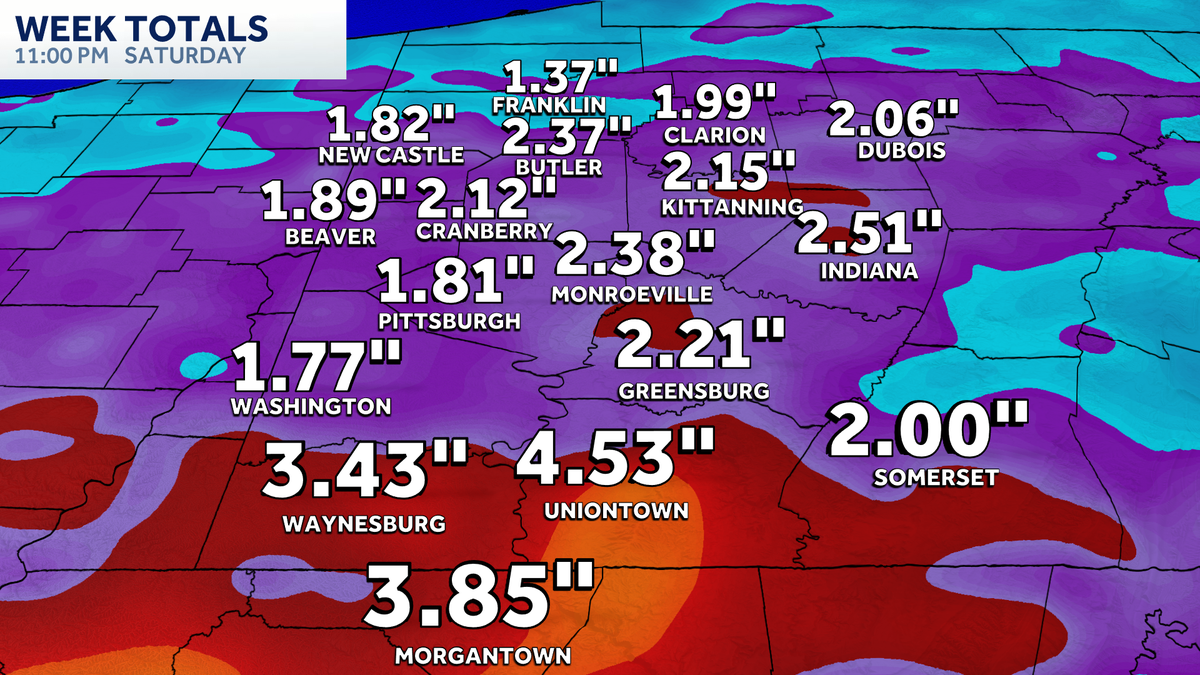
Week total rainfall of one to three inches is expected with locally higher amounts, especially south of Pittsburgh.
Saturday will be our best chance to see thunderstorms as a cold front arrives late in the day. We will have to watch our rivers through the weekend.

Hearst Owned
Rain chances through Saturday but staying warm into next week.
OVERNIGHT: Rain ending, mostly cloudy and foggy. Low 42°
WEDNESDAY: Mostly cloudy with isolated showers. High: 56°, low: 50°.
THURSDAY: Mostly cloudy with rain showers and an isolated thunderstorm. High: 68°, low: 56°.