
Foggy start, scattered showers today in south-central Pennsylvania
Highs will stay in the 40s over the next 3 days; expect rain at times
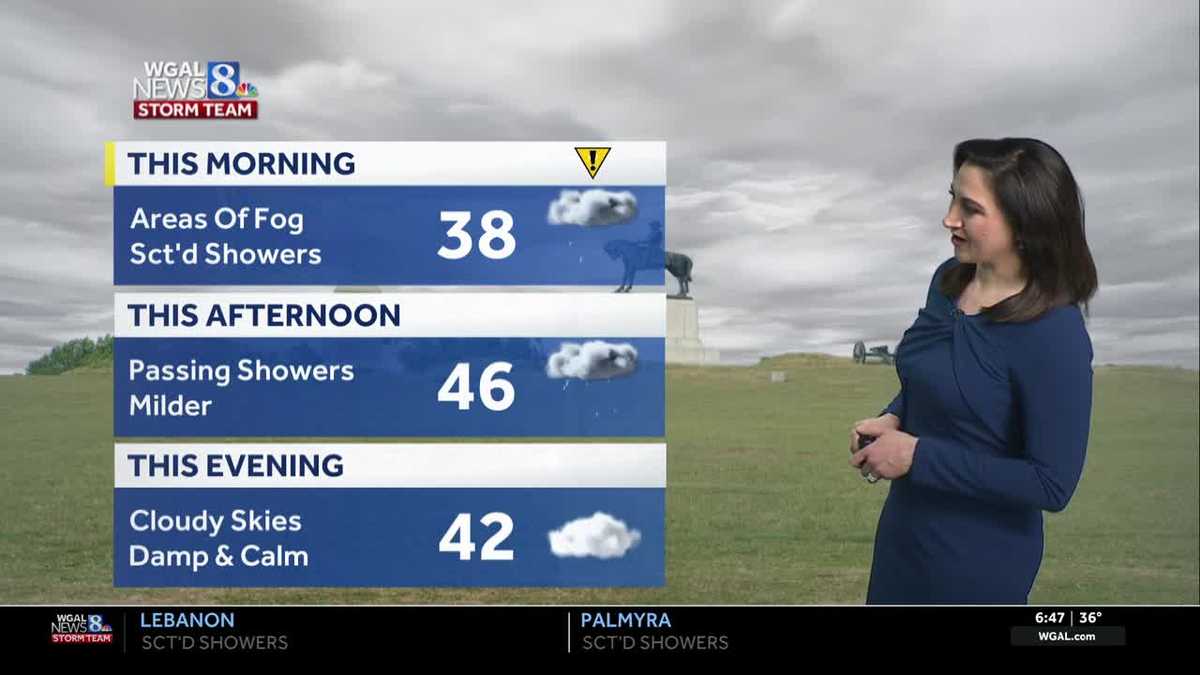
NOW THE WGAL NEWS EIGHT STORM TEAM FORECAST WITH CHIEF METEOROLOGIST CHRISTINE FERREIRA. GOOD MORNING. IT IS 646. WE DO HAVE A DENSE FOG ADVISORY IN EFFECT FOR TWO COUNTIES ONLY LEBANON AND SCHUYLKILL. AND THAT GOES UNTIL 9:00 THIS MORNING. BUT VISIBILITY HAS IMPROVED OVER THE PAST COUPLE OF HOURS. I’M NOT SEEING THAT VERY DENSE FOG THAT WE SAW JUST A FEW HOURS AGO. SO STILL SOME REDUCED VISIBILITY. WE ALSO HAVE SOME SHOWERS GOING BY SOUTH OF THE PA TURNPIKE MAINLY, SO IT’S GOING TO BE A WET AND FOGGY MORNING COMMUTE FOR YOU. THAT MIGHT SLOW YOU DOWN JUST A LITTLE BIT. HERE’S THE PREDICTOR SHOWING THAT SHOWERS PERSIST THROUGH THE MORNING DRIVE. EVEN AROUND LUNCHTIME. WE STILL HAVE THOSE SCATTERED SHOWERS, BUT NOTICE SECOND HALF OF THE DAY AS WE HEAD TOWARD EVENING, THE SHOWERS EXIT AND WE WILL GET SOME DRY TIME OUT THERE. SO IF YOU’RE LOOKING FOR SOME DRY TIME, MAYBE TO GET A WALK IN TODAY WITH TEMPERATURES IN THE 40S, IT’S LOOKING LIKELY LATER IN THE AFTERNOON TOWARD EVENING. HERE’S A LOOK AT OUR NEWS EIGHT STORM TEAM FORECAST TODAY. WE HAVE IMPACTS DUE TO THE FOG. SOME SHOWERS MIGHT SLOW YOU DOWN THIS MORNING, BUT OTHERWISE LOOKING BETTER THIS AFTERNOON. NO 30 IN THE AFTERNOON. FORECAST WILL BUMP TO 46 FOR THE HIGH. THAT’S ABOUT AVERAGE FOR THIS THEN THIS EVENING, CLOUDY, DAMP AND COOL BUT DRY WITH TEMPERATURES IN THE 40S. TONIGHT, NOT SO DRY. RAIN COMES RIGHT BACK IN HERE OVERNIGHT, SO AREAS OF FOG WILL PERSIST. WE WILL HAVE MILD LOWS NEAR 40. WITH THAT RAIN COMING BACK IN TOMORROW, WE’LL BE DEALING WITH RAIN AT THIS TIME DURING THE MORNING COMMUTE. THERE MAY BE SOME BREAKS IN THE AFTERNOON, BUT THEN ANOTHER WAVE OF RAIN COMES IN TOMORROW EVENING. SO WE’LL JUST SAY PERIODS OF RAIN TOMORROW. THE CLOUDS ARE SOCKED IN, TEMPERATURES REACH THE UPPER 40S. RIGHT NOW WE HAVE 37 DEGREES IN LEBANON. SAME IN LANCASTER. GOOD MORNING. HARRISBURG. YOU’RE AT 36. 36 IN LEWISTOWN. 37 DEGREES IN CARLISLE. WINDS ARE CALM OR LIGHT, AND THAT’S WHY THE FOG IS STICKING AROUND. SO HERE’S OUR STORM TEAM. RADAR NETWORK. THESE SHOWERS ARE RIDING ALONG A BOUNDARY TO OUR SOUTH. YOU SEE IT STRETCHED HERE FROM THE ATLANTIC ALL THE WAY BACK INTO THE MIDWEST, AND WAVES OF RAIN ARE GOING TO RIDE ALONG THAT BOUNDARY OVER THE NEXT COUPLE OF DAYS. SO WE TIME IT OUT FOR YOU TODAY. WE HAVE SOME SCATTERED SHOWERS THIS MORNING. TONIGHT, HERE COMES A WAVE OF RAIN RIGHT ON TOP OF US. ABOUT THIS TIME TOMORROW MORNING, WE WILL BE DEALING WITH SOME LIGHT TO MODERATE RAINFALL. THERE WE ARE DURING THE MORNING COMMUTE TOMORROW, AND IT LOOKS LIKE A SOGGY ONE THAT MOVES AWAY A BOUNDARY. A WARM FRONT TRIES TO LIFT NORTH INTO THE AREA ON THURSDAY AFTERNOON, THURSDAY EVENING, BRINGING MORE RAIN BACK IN THE FORECAST. AND THAT BOUNDARY JUST KIND OF ZIPPERS OFF. IT REALLY NEVER MOVES NORTH. WE GET STUCK IN THE CLOUDS, WE GET STUCK IN THE COOL 40S FOR ONE MORE DAY ON FRIDAY. FRIDAY DOES LOOK LIKE A DRIER DAY THOUGH. JUST A COUPLE OF SHOWERS, MAYBE A LITTLE BIT OF DRIZZLE, AND I WON’T EVEN RULE OUT OUR SOUTHWESTERN COUNTIES WARMING INTO THE 50S ON FRIDAY, WHILE THE REST OF THE AREA GETS STUCK IN THE 40S. HERE’S A LOOK AT OUR PREDICTOR ESTIMATED RAINFALL TOTALS. HERE’S THE GOOD NEWS OUT OF ALL THE CLOUDS, WE’RE GOING TO GET BENEFICIAL RAINFALL, WHICH WILL HELP OUR DROUGHT. SO THIS IS A STEADY SOAKING RAIN. SOME SPOTS BY THE TIME WE REACH FRIDAY COULD REACH A HALF INCH TO AN INCH OF RAIN. HERE’S THE TEN DAY FORECAST. THE RAIN CHANCES QUIET DOWN THIS WEEKEND. THERE WILL BE A COLD FRONT THAT COMES THROUGH LATE SATURDAY INTO EARLY SUNDAY WITH A FEW SHOWERS MONDAY, TUESDAY AND WEDNESDAY LOOK MAINLY DRY. THOSE ARE THE WARMEST DAYS IN THEN WE SEE A STRONGER FRONT COMING THROUGH ON THURSDAY,
Foggy start, scattered showers today in south-central Pennsylvania
Highs will stay in the 40s over the next 3 days; expect rain at times

Updated: 7:50 AM EST Mar 4, 2026
IMPACT MORNING FOR FOG: A Dense Fog Advisory is in effect for Lebanon and Schuylkill Counties until 9 a.m. Watch for visibility less than 1/4 mile at times. Other areas not included in the advisory may also have low visibility throughout the morning. As a boundary lingers to our south today, scattered showers are possible from time to time. Look for drier weather by evening. Highs will be warmer than yesterday, in the mid-40s with light winds. Tonight, rain returns after midnight, along with areas of fog. Lows will be mild, near 40 degrees. A warm front will move into Pennsylvania on Thursday, leading to highs in the upper 40s. We’ll see periods of rain and light winds. Rain totals Wednesday and Thursday will range from 0.50″ to 1″ in most areas.As a boundary lingers over Pennsylvania Friday, a few showers are possible, along with areas of drizzle. Highs will be stuck in the mid-40s, due to clouds and easterly flow. WARMER WEEKEND:Highs will climb to 60 degrees Saturday and reach the low 60s Sunday. A weak cold front will approach late Saturday into Sunday morning, leading to scattered showers. Sunday will be mainly dry. After a warm Monday, with highs in the upper 60s, we’ll take a run at 70 degrees Tuesday and Wednesday. A stronger cold front will approach Thursday, leading to scattered showers, and cooler, blustery weather at the end of the week. Expect highs in the upper 40s by Friday.
IMPACT MORNING FOR FOG:
A Dense Fog Advisory is in effect for Lebanon and Schuylkill Counties until 9 a.m. Watch for visibility less than 1/4 mile at times. Other areas not included in the advisory may also have low visibility throughout the morning.
As a boundary lingers to our south today, scattered showers are possible from time to time. Look for drier weather by evening. Highs will be warmer than yesterday, in the mid-40s with light winds.
Tonight, rain returns after midnight, along with areas of fog. Lows will be mild, near 40 degrees.
A warm front will move into Pennsylvania on Thursday, leading to highs in the upper 40s. We’ll see periods of rain and light winds. Rain totals Wednesday and Thursday will range from 0.50″ to 1″ in most areas.
As a boundary lingers over Pennsylvania Friday, a few showers are possible, along with areas of drizzle. Highs will be stuck in the mid-40s, due to clouds and easterly flow.
WARMER WEEKEND:
Highs will climb to 60 degrees Saturday and reach the low 60s Sunday. A weak cold front will approach late Saturday into Sunday morning, leading to scattered showers. Sunday will be mainly dry.
After a warm Monday, with highs in the upper 60s, we’ll take a run at 70 degrees Tuesday and Wednesday. A stronger cold front will approach Thursday, leading to scattered showers, and cooler, blustery weather at the end of the week. Expect highs in the upper 40s by Friday.