
Impact Day Saturday: Storms likely late Saturday afternoon in western Pennsylvania
NIGHT AGAINST THE BUFFALO SABERS. AFTER SEEING FOG AND SOME SHOWERS TODAY. WE’RE WATCHING FOR HEAVY RAIN THAT ARRIVES TONIGHT THAT WILL LAST INTO OUR THURSDAY. THAT PROMPTS AN IMPACT DAY. FRIDAY IS THE DRIER DAY HEADING INTO THE WEEKEND BEFORE WE’RE WATCHING FOR LATE DAY SHOWERS AND STORMS ON SATURDAY. THAT ALSO PROMPTS AN IMPACT IS LIKELY OUR BEST CHANCE OF SEEING WIDESPREAD THUNDERSTORMS ACROSS THE AREA FOR 2026. STILL, A COUPLE OF LIGHT RAIN SHOWERS FALLING, BUT THE WIDESPREAD RAIN IS DONE IN AN ISOLATED SHOWER WILL REMAIN POSSIBLE UNTIL WE GET INTO TONIGHT. THAT’S WHEN THE HEAVIER RAIN BEGINS ARRIVING. 52 IS WHERE WE’LL FINISH TODAY, 63 TOMORROW. THAT RAIN AND AGAIN A STORM IS POSSIBLE. 70 ON FRIDAY. AND THEN WE’RE WATCHING LATE ON SATURDAY FOR RAIN AND STORMS. WE COULD SEE RAIN AS EARLY AS LUNCHTIME, BUT THE STORM CHANCE GETS HERE ABOUT FIVE, 6 OR 7:00. THAT’S WHEN THE COLD FRONT CROSSES. AND AS IT DOES, IT COULD SEE A BROKEN LINE OF THUNDERSTORMS. EVEN A SQUALL LINE ITSELF ROLLING ACROSS WESTERN PENNSYLVANIA. SO WE’RE WATCHING LATE SATURDAY VERY CLOSELY. ONCE THAT FRONT PASSES, IT DROPS OUR TEMPERATURES SUNDAY, BUT WE STAY MILD AT 6367 ON MONDAY AND WE’RE BACK INTO THE MID 70S TUESDAY AND WEDNESDAY BEFORE ANOTHER COLD FRONT GETS HERE EITHER LATE WEDNESDAY OR THURSDAY. SO FOR THE REST OF THE DAY TODAY WE’LL WATCH FOR A FEW ISOLATED SHOWERS. REALLY, AT ANY POINT IT’S NOT A WASHOUT, BUT YOU MAY RUN UNDERNEATH A RAIN SHOWER AS WE HEAD THROUGH THE REST OF THE DAY. AS WE GET TOWARDS 9 OR 10:00, THE FIRST WAVE OF RAIN SHOWERS FOR OUR THURSDAY ARRIVES. WE’LL GO ON IMPACT DAY TONIGHT AS RAIN WILL BE HEAVY AT TIMES. TONIGHT IT WILL STILL BE RAINING BY RUSH HOUR TOMORROW MORNING. THAT’S WAVE NUMBER ONE. WAVE NUMBER TWO GETS HERE ABOUT THIS TIME TOMORROW. THAT WILL CROSS DURING THE EVENING COMMUTE, MAKING IT SOGGY FOR EVENING DRIVERS. AND THEN THE LAST ROUND WILL GET HERE LATE INTO EARLY ON FRIDAY. BY THE TIME WE’RE DONE, WE COULD SEE A COUPLE OF INCHES OF RAIN SOUTH OF PITTSBURGH. SO WE’LL KEEP AN EYE ON THIS. WE WILL SEE RIVER RISES, BUT AT THIS POINT RIVER FLOODING IS NOT CURRENTLY EXPECTED. STILL SOME FOG OUT THERE ON ACTION. CAM 48 IS THE CURRENT TEMPERATURE AT PITTSBURGH INTERNATIONAL. WE WON’T REALLY WARM MUCH FOR THE REST OF THE DAY TODAY. LOW 50S THE BEST WILL BE ABLE TO
Impact Day Saturday: Storms likely late Saturday afternoon in western Pennsylvania

Updated: 2:55 PM EST Mar 4, 2026
A cold front dropping into western Pennsylvania will bring rain showers and thunderstorms Saturday.The cold front looks to arrive around dinner, bringing our best chance to see storms so far in 2026.Severe weather alerts: Get FREE alerts to your phone or emailInteractive radar: Track storms in your areaLearn how to enable automatic weather alerts on the WTAE app TimingRain showers could develop at any point in the day in advance of the cold front. It will be warm with temperatures into the 70s. The cold front looks to arrive between 5 p.m. and 7 p.m.ThreatsThis does not look to be a widespread severe weather event for the area. We will likely see either a broken line of thunderstorms or a squall line of storms as the cold front arrives. With any line of storms, our main threats are damaging winds and small hail. A brief, isolated tornado cannot be ruled out at this point. Flooding is not likely as the line of storms will be moving quickly, but if heavy rain falls on areas with swollen rivers from all of our rain this week, localized flooding is possible.ImpactsTravel will be difficult as the cold front passes and the rain and wind pick up late in the day. No significant severe weather impacts are currently expected, but we will continue to fine-tune the forecast as we get closer.
PITTSBURGH —
A cold front dropping into western Pennsylvania will bring rain showers and thunderstorms Saturday.
The cold front looks to arrive around dinner, bringing our best chance to see storms so far in 2026.
Timing
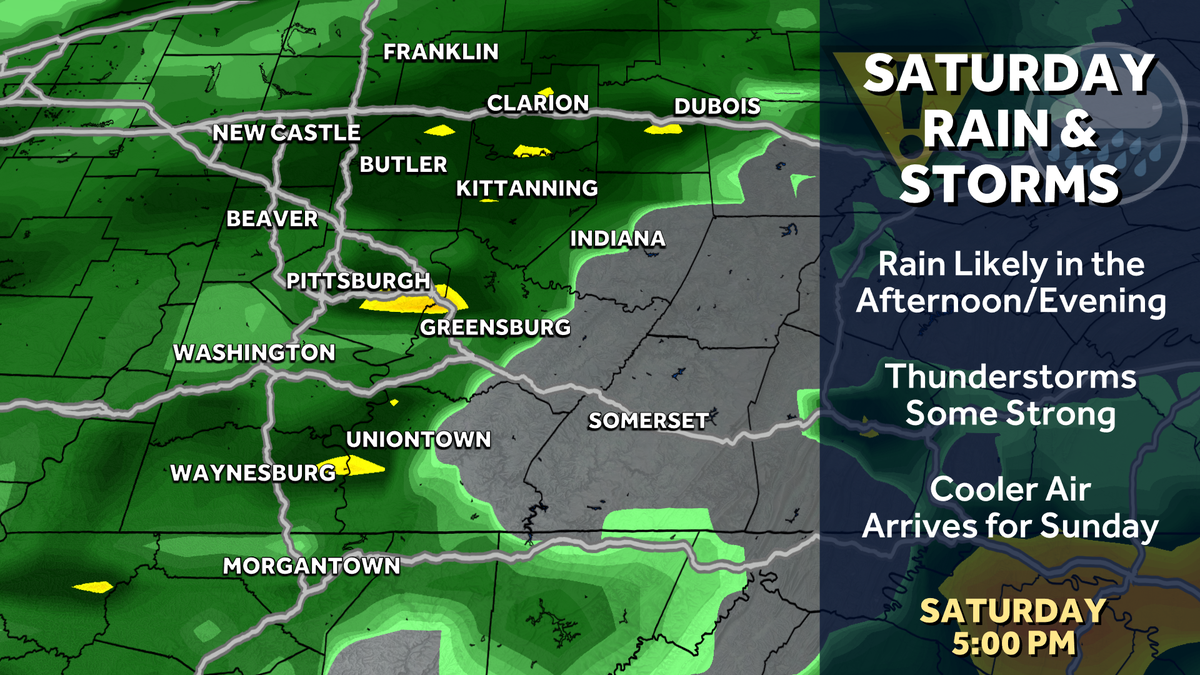
Rain showers could develop at any point in the day in advance of the cold front. It will be warm with temperatures into the 70s. The cold front looks to arrive between 5 p.m. and 7 p.m.

Hearst Owned
Rain and storms will have the greatest coverage and intensity late Saturday.
Threats
This does not look to be a widespread severe weather event for the area. We will likely see either a broken line of thunderstorms or a squall line of storms as the cold front arrives. With any line of storms, our main threats are damaging winds and small hail. A brief, isolated tornado cannot be ruled out at this point. Flooding is not likely as the line of storms will be moving quickly, but if heavy rain falls on areas with swollen rivers from all of our rain this week, localized flooding is possible.

Hearst Owned
Overall severe weather threats are low for Saturday, and the type of line of storms we see will determine how strong the threats are late Saturday.
Impacts
Travel will be difficult as the cold front passes and the rain and wind pick up late in the day. No significant severe weather impacts are currently expected, but we will continue to fine-tune the forecast as we get closer.