
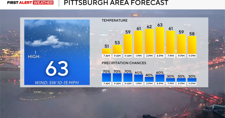
Widespread morning rain will become scattered this afternoon throughout the Pittsburgh area.
Any Alert Days Ahead? Saturday has now been updated to a slight (level 2 out of 5) severe weather day. Will put a probable tag on it now and it will probably be a First Alert Weather Day soon.
Aware: Yesterday’s rain total for Pittsburgh was 0.2″.
Rain chances are sticking around for the third day in a row. Two days ago we saw 0.47″ of rain. Yesterday we recorded 0.2″ of rain. An additional quarter of an inch should be expected today, with a few neighborhoods seeing up to maybe three-fourths of an inch of rain.

KDKA Weather Center
Higher totals would be due to catching one of the heavier cells, potentially turning into a thunderstorm, that will roll through between 4 p.m. to 5 p.m.
If you are adventurous, grab the umbrella and get outside to enjoy 60 degree afternoon temperatures today. It will feel nice.
Morning temperatures started off in the 50s, and mild to warm starts is going to be in place over the next week. It will feel nice.

KDKA Weather Center
I have temperatures warming to the 70s for highs both on Friday and Saturday.
Severe weather could arrive in the area on Saturday
Looking a little closer at Saturday, there will be a chance for severe weather due to strong winds. Right now, it looks like the best chance for severe storms will come during the late afternoon hours between 5 p.m. and 7 p.m. When it comes to model data of upper air soundings, little in the way of instability will be present on Saturday, but we will have strong winds just above ground level.

KDKA Weather Center
As these winds mix down to the surface ahead of a cold front we should see some fast-moving storms develop.