
A Dense Fog Advisory is in effect for all counties until 7 a.m. Visibility may drop to a 1/4 mile or less. Please allow extra time for the morning commute, use low beams, and increase following distance. In addition, light to moderate rain is falling, along with areas of drizzle. Watch for ponding on the roads. Rain will taper by late morning, and temperatures will hover in the low 40s. After several dry hours this afternoon, rain will return this evening, and could be moderate to briefly heavy at times. Rain totals will range from 0.50″ to 1″ from the two rounds of rain today.Overnight lows will fall to 40 degrees under cloudy skies. Due to damp, calm conditions, fog will redevelop.We have one more cloudy and cool day Friday, due to persistent easterly flow. Isolated showers and patchy drizzle is possible. Highs will reach the mid-40s. WARMER WEEKEND:Saturday will start with cloudy skies, but breaks of sun are possible by afternoon. Highs will reach the upper 50s. A weak cold front will approach Saturday evening into Sunday morning, leading to scattered showers. Sunday will be mainly dry, with more sunshine and highs in the low 60s.After a warm Monday, with highs around 66 degrees, we’ll take a run at 70 degrees on Tuesday and Wednesday. A stronger cold front will approach Thursday, leading to scattered showers and cooler, breezy weather at the end of the week. Expect highs in the 50s Thursday and upper 40s Friday.
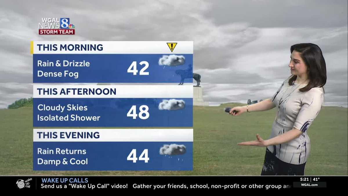
A Dense Fog Advisory is in effect for all counties until 7 a.m. Visibility may drop to a 1/4 mile or less. Please allow extra time for the morning commute, use low beams, and increase following distance.
In addition, light to moderate rain is falling, along with areas of drizzle. Watch for ponding on the roads. Rain will taper by late morning, and temperatures will hover in the low 40s.
After several dry hours this afternoon, rain will return this evening, and could be moderate to briefly heavy at times. Rain totals will range from 0.50″ to 1″ from the two rounds of rain today.
Overnight lows will fall to 40 degrees under cloudy skies. Due to damp, calm conditions, fog will redevelop.
We have one more cloudy and cool day Friday, due to persistent easterly flow. Isolated showers and patchy drizzle is possible. Highs will reach the mid-40s.
WARMER WEEKEND:
Saturday will start with cloudy skies, but breaks of sun are possible by afternoon. Highs will reach the upper 50s. A weak cold front will approach Saturday evening into Sunday morning, leading to scattered showers. Sunday will be mainly dry, with more sunshine and highs in the low 60s.
After a warm Monday, with highs around 66 degrees, we’ll take a run at 70 degrees on Tuesday and Wednesday. A stronger cold front will approach Thursday, leading to scattered showers and cooler, breezy weather at the end of the week. Expect highs in the 50s Thursday and upper 40s Friday.