
On and off rain will continue through the evening. We are watching the chance for stronger storms late on Saturday. Thursday: Impact Day for heavy rain/stormsToday is an Impact Day with pockets of heavy rain at times and a small chance for an isolated thunderstorm. Rain will taper off this evening.By the time rain is done, we could be seeing an inch of rain across western Pennsylvania with higher amounts south of Pittsburgh. We will have to keep an eye on area rivers, especially the Mon and Yough, as they will see river rises. Right now, no river is expected to hit flood stage.Saturday: Severe Weather Alert Day for late day storms and rainFriday is looking to be more on the dry side before we head into Saturday, which has been upgraded to a Severe Weather Alert Day. We will have our best chance to see thunderstorms and heavy rain in the area on Saturday.Some showers may develop in the afternoon ahead of a cold front that looks to get here late in the day. As the front arrives, we will have warmed well into the 70s. The warm air will provide fuel for storms as the cold front drops in around dinner. Any storm that does develop could produce strong winds and heavy rain. The system should move fast enough that flooding is not a major concern, but if we see heavy rain on swollen rivers, that could push them out of their bank.We will stay warm through the middle of next week. Another cold front arrives on Wednesday to bring rain and drop temperatures to more seasonal levels.TONIGHT: Cloudy with areas of fog. Low: 56°.FRIDAY: Partly to mostly cloudy with an isolated shower possible. High: 70°, low: 58°.SATURDAY – SEVERE WEATHER ALERT DAY: Sun and clouds with afternoon and evening rain and storms. High: 75°, low: 47°. Wind gusts to 30 mph outside of storms.SUNDAY: Partly cloudy and mild. High: 60°, low: 44°.
PITTSBURGH —
On and off rain will continue through the evening. We are watching the chance for stronger storms late on Saturday.
Thursday: Impact Day for heavy rain/storms
Today is an Impact Day with pockets of heavy rain at times and a small chance for an isolated thunderstorm. Rain will taper off this evening.

By the time rain is done, we could be seeing an inch of rain across western Pennsylvania with higher amounts south of Pittsburgh. We will have to keep an eye on area rivers, especially the Mon and Yough, as they will see river rises. Right now, no river is expected to hit flood stage.
Saturday: Severe Weather Alert Day for late day storms and rain
Friday is looking to be more on the dry side before we head into Saturday, which has been upgraded to a Severe Weather Alert Day. We will have our best chance to see thunderstorms and heavy rain in the area on Saturday.

Hearst Owned
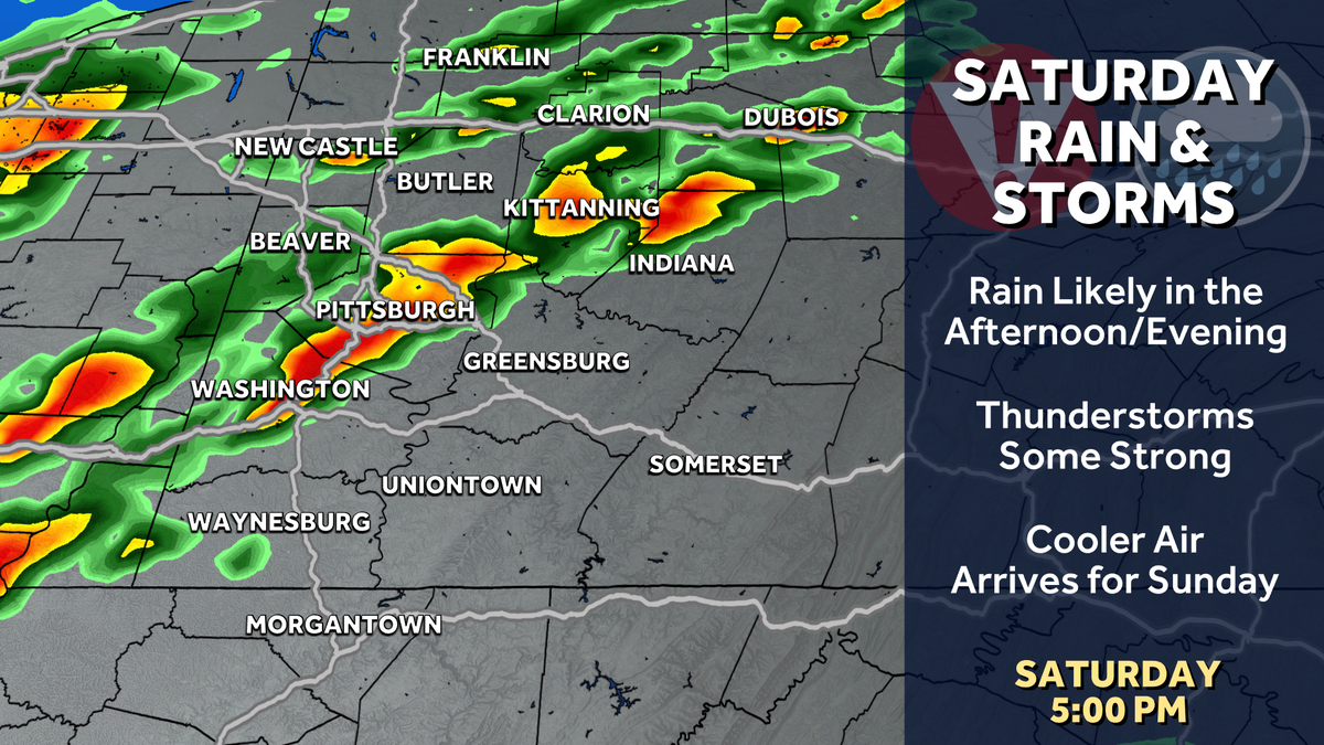
A line of storms will move into the area between about 5 and 8 p.m. Saturday.
Some showers may develop in the afternoon ahead of a cold front that looks to get here late in the day. As the front arrives, we will have warmed well into the 70s. The warm air will provide fuel for storms as the cold front drops in around dinner. Any storm that does develop could produce strong winds and heavy rain. The system should move fast enough that flooding is not a major concern, but if we see heavy rain on swollen rivers, that could push them out of their bank.

Hearst Owned
Damaging wind is the primary concern from any storm on Saturday.
We will stay warm through the middle of next week. Another cold front arrives on Wednesday to bring rain and drop temperatures to more seasonal levels.

Hearst Owned
Warm with rain and storms through Saturday. We stay warm into the middle of next week before a return to March late week.
TONIGHT: Cloudy with areas of fog. Low: 56°.
FRIDAY: Partly to mostly cloudy with an isolated shower possible. High: 70°, low: 58°.
SATURDAY – SEVERE WEATHER ALERT DAY: Sun and clouds with afternoon and evening rain and storms. High: 75°, low: 47°. Wind gusts to 30 mph outside of storms.
SUNDAY: Partly cloudy and mild. High: 60°, low: 44°.