
Why has it been so gloomy across south-central Pennsylvania?
We’ve been dreary, damp, and cloudy for the last several days. We’ve been asked why the area is seeing gloomy conditions, and we have those details for you below.
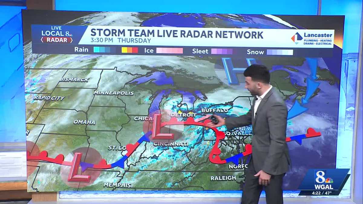
WEATHER. AND IT’S BEEN A GLOOMY PATTERN HERE. FOR MORE ON THAT, LET’S GO OVER TO METEOROLOGIST RYAN. OUR TEAM. MIKE, YOU’VE BEEN TALKING ABOUT THE GLOOMY PATTERN AND ALSO SOME OF THAT SUNSHINE. REALLY I JUST SOCKED AWAY ACROSS THE SUSQUEHANNA VALLEY, AND THAT’S BECAUSE WE’VE BEEN DEALING WITH WITH BACK TO BACK LOW PRESSURE SYSTEMS AND ALSO SOME COLDER AIR COMING IN FROM THE NORTHEAST. SO LET’S CHAT ABOUT IT A LITTLE BIT. SO HERE’S STORM TEAM LIVE RADAR. THIS IS WHAT WE’RE SEEING AT THIS TIME. BUT I WANT TO ZOOM OUT THE PICTURE AND REALLY GIVE YOU A BIG PICTURE OF WHAT WE’RE SEEING. SO I’LL STEP OFF ON THIS SIDE TO SHOW YOU. YOU SEE THIS BIG AREA OF HIGH PRESSURE THAT’S HAPPENING. YOU SEE THE BLUE ARROWS THAT ARE COMING IN OVER THE ATLANTIC. SO THIS IS THERE’S COLD AIR THAT’S COMING IN FROM CANADA. SO WHAT HAPPENS? YOU KNOW, WE HAVE THIS THE APPALACHIAN MOUNTAINS, RIGHT? SO WHAT HAPPENS IS THAT THIS COLD AIR GETS DAMMED UP OR TRAPPED UP AGAINST THE APPALACHIANS. AND SO WHEN YOU HAVE THAT COLDER AIR THAT KEEPS IT COOLER OUTSIDE, AND THEN ALSO LOOK AT THIS CONVEYOR BELT OF DIFFERENT LOW PRESSURE SYSTEMS AND ALL THESE FRONTAL BOUNDARIES THAT CREATES MORE MOISTURE AND ALSO ALLOWING MORE CHANCES FOR THERE TO BE SOME RAIN SHOWERS. SO THAT’S WHAT THAT’S SOME OF THE DETAILS THERE. SO IF YOU WANTED TO SPELL IT OUT FOR YOU THERE, THE WARMER AIR ALOFT ACTS LIKE A LID AND KEEPS THAT COOLER AIR STAYING NEAR THE SURFACE. THAT COLDER AIR FROM THE OCEAN DAMS UP AGAINST THE MOUNTAINS. WE’LL SEE SOME LIGHT IN WITH THOSE LIGHT WINDS. THERE’S BARELY ANY MIXING. SO THAT’S WHY WE’VE BEEN SO DAMP AND SO COOL ACROSS THE AREA. BUT I WILL SAY WE DEFINITELY NEED THE RAIN, SO IT’S NICE THAT WE DO HAVE THE RAIN. YEAH, I’M LAUGHING A LITTLE BIT BECAUSE IT SAID HERE IN THE RUNDOWN IT SAID, RYAN, WHY SO GLOOMY? YEAH, YOU ANSWERED IT. YOU ANSWERED, WHY SO GLOOMY? I JUST FIGURED YOU COULDN’T, YOU KNOW, GET TO THE 70S WITHOUT A LITTLE SOMETHING. SUNSHINE RETURN. THAT’S WHAT I’M TALKING. WELL, WE KNOW WHAT’S COMING NEXT WEEK, RIGHT? IT’S COMING NEXT WEEK. IT’S COMING. AND MICHAEL AND I LOOKED AT EACH OTHER. ONCE YOU START TALKING ABOUT DAYLIGHT SAVINGS, I CAN’T BELIEVE IT’S ALREADY HERE. I KNOW, YEAH, AND THE 7:00 SUNSETS. THAT’S GOING TO BE REALLY NICE. AND YOU GET ALL THE WAY BECAUSE OUR PRODUCER LUCY WAS ASKING ALL THE WAY UNTIL ACTUALLY THE FIRST DAY OF FALL. SO WE GET ALL SPRING AND ALL
Why has it been so gloomy across south-central Pennsylvania?
We’ve been dreary, damp, and cloudy for the last several days. We’ve been asked why the area is seeing gloomy conditions, and we have those details for you below.

Updated: 4:54 PM EST Mar 5, 2026
If you’ve been wondering why we’ve had dreary & damp conditions these last several days, there have been a few things that have setup nearby that have allowed these conditions. We have warmer air that is surging in from the south, and then colder air surging in from the north-northeast, thanks to high pressure settled in over Canada. The sinking, colder air gets dammed up against the Appalachians, and the rising, warmer air from the south acts as a cap & traps the colder air at the surface.In addition, we have a conveyor belt of low pressure systems and frontal boundaries that have been coming in from out west, which has been helping to provide more moisture and rain showers to fall across the Valley.
If you’ve been wondering why we’ve had dreary & damp conditions these last several days, there have been a few things that have setup nearby that have allowed these conditions. We have warmer air that is surging in from the south, and then colder air surging in from the north-northeast, thanks to high pressure settled in over Canada. The sinking, colder air gets dammed up against the Appalachians, and the rising, warmer air from the south acts as a cap & traps the colder air at the surface.

Hearst OwnedWGAL
Surface analysis from the News 8 Storm Team

Hearst OwnedWGAL
Explainer for why it has been so damp & cool across the Valley.
In addition, we have a conveyor belt of low pressure systems and frontal boundaries that have been coming in from out west, which has been helping to provide more moisture and rain showers to fall across the Valley.