
HEAD TO BED ON SATURDAY NIGHT. NOW LET’S GO TO CHRISTINE. LAST NIGHT YOU MIGHT HAVE HEARD THE THUNDER, THE LIGHTNING, THE HEAVY RAIN. LET ME SHOW YOU THE RAINFALL REPORTS OVER THE PAST 24 HOURS IN HERSHEY. YOU PICKED UP OVER AN INCH. COLUMBIA, LANCASTER COUNTY, ALMOST AN INCH. ABOUT 8/10 FOR MOUNT HOLLY SPRINGS. BENEFICIAL RAIN IN BLUE RIDGE SUMMIT. UNDER THAT SEVERE DROUGHT, 0.61 THAT WILL HELP AN IMPORTANT PORT ROYAL. YOU HAD OVER A HALF INCH OF RAIN. SOME OTHER SPOTS. JONESTOWN WELL OVER AN INCH. MARYSVILLE OVER AN INCH.
The past several days in south-central Pennsylvania have been foggy and damp, with frequent scattered showers.Thursday night brought thunder and lightning as heavy rain moved through.Rainfall totals varied widely, with some areas picking up more than an inch while others saw closer to a half-inch.Here are the latest rainfall totals from the past 24 hours:Jonestown, Lebanon County: 1.56″ Marysville, Perry County: 1.06″ Thomasville, York County: 0.77″ Lewistown, Mifflin County: 0.72″ Cashtown, Adams County: 0.49″ Hershey, Dauphin County: 1.17″ Columbia, Lancaster County: 0.94″ Mount Holly Springs, Cumberland County: 0.80″ Blue Ridge Summit, Franklin County: 0.61″ Port Royal, Juniata County: 0.55″ Looking aheadA cold front on Saturday evening will bring scattered rain showers, which could be heavy at times with rumbles of thunder. The showers are expected to end by sunrise on Sunday. Don’t forget to change your clocks on Sunday to “spring forward” for the start of daylight saving time. You’ll lose an hour of sleep, but gain more daylight during the evenings, with later sunsets and earlier sunrises. SOUTH-CENTRAL PA WEATHER RESOURCES: INTERACTIVE RADAR | ACTIVE WEATHER ALERTS | CURRENT CONDITIONS | HOURLY FORECAST | 10-DAY FORECAST | WEEKEND FORECAST | MAP ROOM | DOWNLOAD THE APP | WEATHER EMAILS
The past several days in south-central Pennsylvania have been foggy and damp, with frequent scattered showers.
Thursday night brought thunder and lightning as heavy rain moved through.
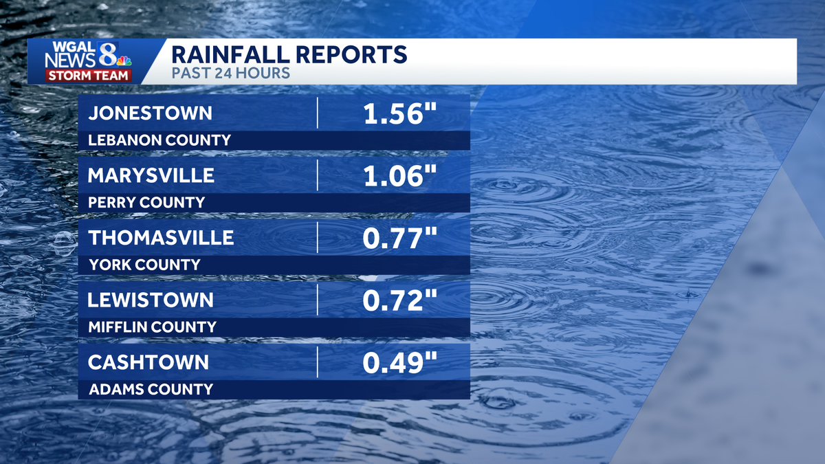
Rainfall totals varied widely, with some areas picking up more than an inch while others saw closer to a half-inch.
Here are the latest rainfall totals from the past 24 hours:
Jonestown, Lebanon County: 1.56″ Marysville, Perry County: 1.06″ Thomasville, York County: 0.77″ Lewistown, Mifflin County: 0.72″ Cashtown, Adams County: 0.49″ Hershey, Dauphin County: 1.17″ Columbia, Lancaster County: 0.94″ Mount Holly Springs, Cumberland County: 0.80″ Blue Ridge Summit, Franklin County: 0.61″ Port Royal, Juniata County: 0.55″


Looking ahead
A cold front on Saturday evening will bring scattered rain showers, which could be heavy at times with rumbles of thunder. The showers are expected to end by sunrise on Sunday.

Don’t forget to change your clocks on Sunday to “spring forward” for the start of daylight saving time. You’ll lose an hour of sleep, but gain more daylight during the evenings, with later sunsets and earlier sunrises.

SOUTH-CENTRAL PA WEATHER RESOURCES: INTERACTIVE RADAR | ACTIVE WEATHER ALERTS | CURRENT CONDITIONS | HOURLY FORECAST | 10-DAY FORECAST | WEEKEND FORECAST | MAP ROOM | DOWNLOAD THE APP | WEATHER EMAILS