
Foggy Overnight; Warmer Weekend With Scattered Storms Late Saturday In South Central Pennsylvania
After a warm weekend, temperatures will soar to the 70s early next week.
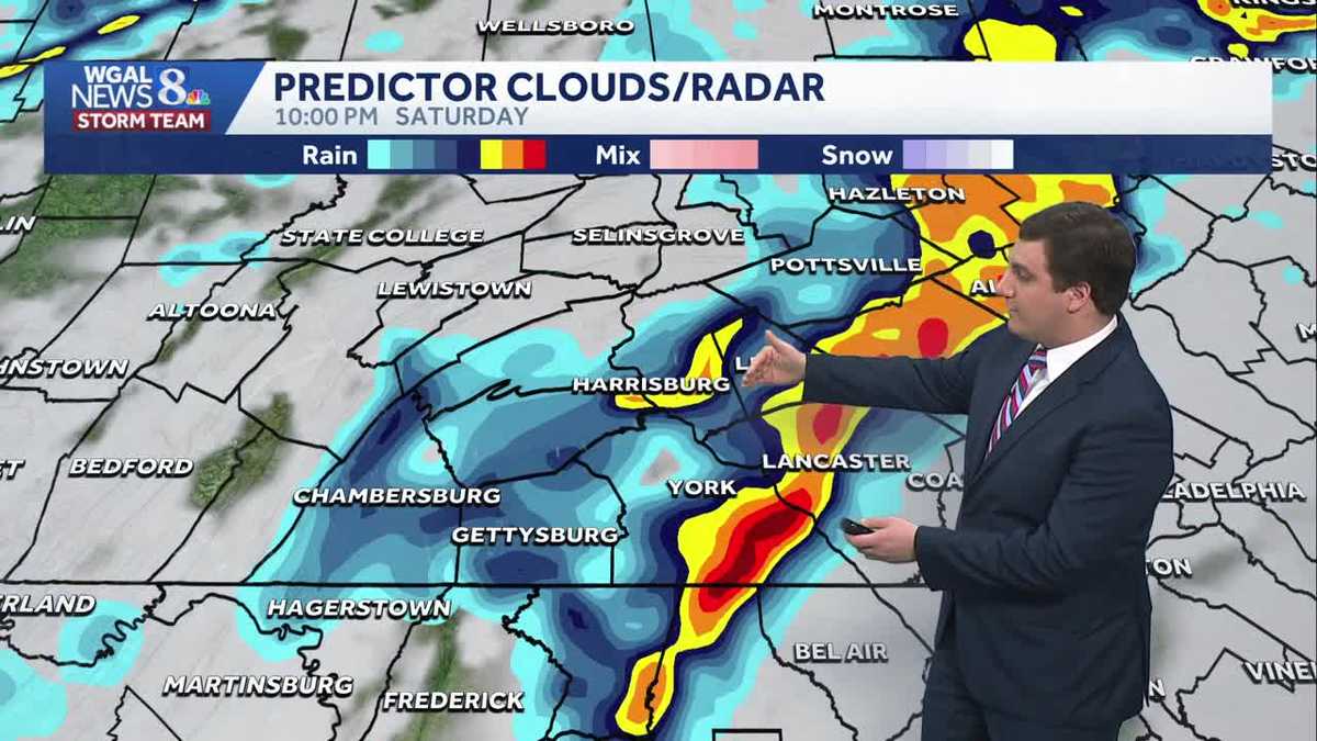
THAT WOULD BE BEST FIT FOR OUR COMMUNITY. NOW, THE WGAL NEWS EIGHT STORM TEAM FORECAST, WITH METEOROLOGIST MIKE SUSKO. AND GOOD EVENING, EVERYONE. A WARMER WEEKEND IS ON TAP HERE ACROSS THE AREA. WE’LL SEE OUR TEMPERATURES GET INTO THE 50S TOMORROW AND THEN 60S BY THE TIME WE GET TO SUNDAY. HOWEVER, TOMORROW NIGHT WE COULD BE WATCHING FOR SOME SHOWERS AND THUNDERSTORMS HERE AS A COLD FRONT WILL COME ON THROUGH AND MAY GIVE US SOME SHOWERS AND STORMS LATE SATURDAY NIGHT INTO EARLY SUNDAY MORNING. AFTER THAT, WE GO INTO THE 60S AND 70S TO START OFF NEXT WEEK HERE. IT’S GOING TO BE REALLY NICE ACROSS PARTS OF THE AREA, INCLUDING IN CUMBERLAND COUNTY. GOOD EVENING TO YOU. IN CARLISLE. IT’S CLOUDY AND DREARY, JUST LIKE IT’S BEEN ALL WEEK SO FAR, BUT AND TEMPERATURES ARE RIGHT NOW IN THE 40S, WE ARE SEEING SOME SHOWERS RIGHT ALONG THE PENNSYLVANIA MARYLAND BORDER IN PARTS OF ADAMS AND YORK COUNTY HERE. THAT’S PRETTY MUCH ONLY AMOUNT OF RAIN I EXPECT AS WE GO THROUGH THE EVENING HOURS AND TEMPERATURES FOR MOST OF THE SUSQUEHANNA VALLEY AT THE MOMENT ARE IN THE 40S, 43 IN HARRISBURG, 42 IN LANCASTER, 43, IN CARLISLE, 46 IN GETTYSBURG, 51 IN CHAMBERSBURG. IF YOU WANT THE WARMER WEATHER, YOU DON’T HAVE TO GO TOO FAR AWAY. JUST GO TO PITTSBURGH, WHERE IT’S CURRENTLY 70 DEGREES. SO YEAH, WESTERN PENNSYLVANIA IS GETTING ALL THE NICE WEATHER. WE ARE STUCK IN THE COLD HERE. YOU CAN THANK THE APPALACHIAN MOUNTAINS FOR ALL THAT AND KEEPING US LOCKED IN THE COLD AIR WITH AN EASTERLY WIND. AS WE GO INTO THE NIGHT. TONIGHT WE’LL HAVE THE CLOUDY SKIES AND AN ISOLATED SHOWER FOR OUR SOUTHERN AREAS FOR THE NEXT FEW HOURS. OTHERWISE, TEMPERATURES ARE PRETTY MUCH STAYING WHERE THEY ARE. THEY’RE NOT GOING TO CHANGE VERY MUCH. AREAS OF FOG WILL DEVELOP OVERNIGHT TONIGHT ONCE AGAIN, SO KEEP THAT IN MIND IF YOU’RE GOING OUT EARLY TOMORROW MORNING, YOU MAY ENCOUNTER SOME OF THAT WILL BE RIGHT AROUND 40 DEGREES FOR TOMORROW MORNING AS WE GO THROUGH THE NIGHT TONIGHT, A FRONT THAT’S NEARBY THAT’S GOING TO BE LIFTING TO THE NORTH, THAT HELPS US WARM THINGS UP A LITTLE BIT AS WE GO INTO SATURDAY, STARTING OFF WITH SOME CLOUDS, MAYBE A LITTLE BIT OF SUNSHINE HERE AS WE GO INTO THE DAY TOMORROW. WE ACTUALLY DON’T WANT THE SUNSHINE. HERE’S WHY. AS WE GO INTO TOMORROW AFTERNOON, SUNSHINE IS GOING TO ADD FUEL TO THE ATMOSPHERE FOR THUNDERSTORMS TO DEVELOP. AND AS WE GO INTO THE 5:00 HOUR, 1 OR 2 STORMS MAY POP UP HERE SOME BACK AND FORTH WITH THE MODELS ON THAT. BUT THAT LINE THAT YOU SEE OFF TO THE WEST THAT WILL BEGIN TO APPROACH RIGHT AROUND SEVEN 8:00. SUNSHINE WILL ADD FUEL FOR THIS, AND IT WILL KEEP THE STRONGER STORMS AROUND LONGER. SO YOU ACTUALLY WANT THE CLOUD COVER TOMORROW. IT HELPS OUT TO WEAKEN THE STORMS. NOW THIS LINE OVERALL, JUST BECAUSE OF THE TIME OF DAY, IS GOING TO BE WEAKENING AS IT MOVES INTO THE SUSQUEHANNA VALLEY. WE TAKE AWAY THE SUNSHINE THAT WILL HELP LIMIT THE AMOUNT OF FUEL THAT WE HAVE WITH IT. BUT YOU CAN SEE FROM AROUND EIGHT TO ABOUT 10:00, THAT’S GOING TO BE OUR WINDOW OF OPPORTUNITY, SO TO SPEAK, WITH THAT MAIN LINE COMING THROUGH, COULD SEE SOME DOWNPOURS WITH THIS, SOME LIGHTNING, MAYBE GUSTY WINDS AS IT MOVES ON THROUGH. AND THEN AFTER MIDNIGHT. THINGS WILL CALM DOWN WITH THAT. SO FOR TOMORROW WE DO GET INTO THE 50S. THE HIGH IS ACTUALLY GOING TO OCCUR CLOSER TO MIDNIGHT. SO FOR SOME OF YOU, YOU’RE GOING TO BE IN THE 40S IN THE AFTERNOON. IT WILL TAKE SOME TIME TO GET INTO THE 50S TOMORROW WITH THAT FRONT COMING IN. BUT ONCE WE GET TO THE 50S, YOU’LL STAY THERE AS WE GO INTO TOMORROW EVENING. AND TOMORROW NIGHT. THERE IS A RISK FOR SOME STRONG STORMS. MOST OF THAT IS IN WESTERN PENNSYLVANIA. BUT FOR US HERE IN THE SUSQUEHANNA VALLEY, A LEVEL ONE OUT OF FIVE RISK FOR MAYBE A STRONG STORM OR TWO. NOT OUT OF THE QUESTION. AGAIN, WE JUST SAW BETWEEN THAT 5:00 EVENING TO MIDNIGHT TOMORROW NIGHT AS THAT WEAKENING LINE OF STORMS MOVES IN FROM THE WEST. JUST BE ON THE LOOKOUT FOR SOME BRIEF HEAVY RAIN AND SOME LIGHTNING POSSIBLE. COULD SEE SOME GUSTY WINDS AS WELL AS IT COMES THROUGH. IT’S REALLY NOT LOOKING LIKE IT’S GOING TO BE A BIG ONE FOR US, BUT NONETHELESS, WE’LL KEEP AN EYE ON IT FOR YOU. 62 WILL BE THE HIGH ON SUNDAY ONCE WE GET RID OF THE STORMS AND MAYBE SOME SUNSHINE THERE FOR YOUR SUNDAY IN THE AFTERNOON. AS WE SEE THE 70S THERE ON TUESDAY AND WEDNESDAY. WEDNESDAY. WE ALSO HAVE TO WATCH FOR SOME SHOWERS, MAYBE SOME THUNDERSTORMS AS THE FRONT COMES THROUGH AND THAT WILL KNOCK US BACK
Foggy Overnight; Warmer Weekend With Scattered Storms Late Saturday In South Central Pennsylvania
After a warm weekend, temperatures will soar to the 70s early next week.

Updated: 5:10 PM EST Mar 6, 2026
Good evening,Another evening of cloudy & damp conditions remains, due to persistent onshore easterly flow. Isolated showers are possible, mainly toward evening. Temperatures will drop through the mid-40s.Tonight, lows will fall to 40 degrees under cloudy skies. Areas of fog will redevelop.Saturday will feature clouds to start, then breaks of sun by afternoon west of the Susquehanna River. Clouds will linger east. Highs will be warmer, in the low 50s, but they may not occur until late in the day.A cold front will approach from the west Saturday evening, leading to scattered showers and thunderstorms, which could be heavy at times. While there is a marginal (level 1/5) risk for strong thunderstorms, the line of storms will be on a weakening trend as they move into the Susquehanna Valley. Expect brief periods of heavy rain, some lightning, and gusty winds after sunset on Saturday. Showers will end around midnight on Sunday.As the cold front moves away from the area on Sunday morning, look for gradual clearing. Highs will reach the low 60s with a light breeze.Monday and Tuesday will feature partly to mostly sunny skies and highs in the upper 60s to low 70s.A stronger cold front will approach on Wednesday, bringing showers across the Susquehanna Valley by evening. Highs will reach the low 70s.Showers wrap up early Thursday, and temperatures will be much cooler. Expect highs in the low 50s with a brisk breeze.A few showers are possible Friday into Saturday; otherwise, expect typical temperatures for mid-March, in the upper 40s to low 50s at the end of the week.Have a great night!
Good evening,
Another evening of cloudy & damp conditions remains, due to persistent onshore easterly flow. Isolated showers are possible, mainly toward evening. Temperatures will drop through the mid-40s.
Tonight, lows will fall to 40 degrees under cloudy skies. Areas of fog will redevelop.
Saturday will feature clouds to start, then breaks of sun by afternoon west of the Susquehanna River. Clouds will linger east. Highs will be warmer, in the low 50s, but they may not occur until late in the day.
A cold front will approach from the west Saturday evening, leading to scattered showers and thunderstorms, which could be heavy at times. While there is a marginal (level 1/5) risk for strong thunderstorms, the line of storms will be on a weakening trend as they move into the Susquehanna Valley. Expect brief periods of heavy rain, some lightning, and gusty winds after sunset on Saturday. Showers will end around midnight on Sunday.
As the cold front moves away from the area on Sunday morning, look for gradual clearing. Highs will reach the low 60s with a light breeze.
Monday and Tuesday will feature partly to mostly sunny skies and highs in the upper 60s to low 70s.
A stronger cold front will approach on Wednesday, bringing showers across the Susquehanna Valley by evening. Highs will reach the low 70s.
Showers wrap up early Thursday, and temperatures will be much cooler. Expect highs in the low 50s with a brisk breeze.
A few showers are possible Friday into Saturday; otherwise, expect typical temperatures for mid-March, in the upper 40s to low 50s at the end of the week.
Have a great night!