
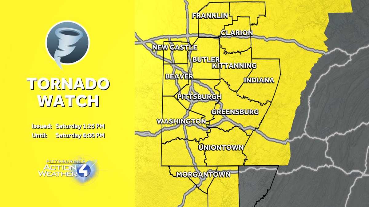
The National Weather Service has issued a tornado watch for Western Pennsylvania until 8 p.m. Saturday. A line of stronger thunderstorms will cross between 4 p.m. and 8 p.m. Damaging winds are the leading threat.Severe Weather Alert Day: PM line of thunderstormsThe first half of the day will be quiet with sun and clouds and windy conditions. Winds will gust between 30 and 50 mph.Pittsburgh could also challenge the record high. We are forecasting 76 degrees, tying the record from 1983.Showers and storms develop this afternoon ahead of a cold front. This is an area-wide threat with the bulk of the storms passing between 4 and 8 p.m. The line of thunderstorms will arrive from the northwest and exit through the Laurel Highlands. Stronger storms that develop will produce strong winds and heavy rain. The system should move fast enough that flooding is not a major concern.Clocks “spring forward,” temperatures dropDaylight Saving Time begins at 2 a.m. Sunday. It is time to turn the clocks ahead one hour. However, temperatures will dip slightly behind the potent front. Highs will only warm close to 60 degrees. Clouds will gradually give way to more sunshine by the afternoon. It will also remain breezy to wrap up the weekend.More rain Wednesday – Impact DayTemperatures rebound into the 70s to begin the new week. Sunshine is on tap Monday followed by limited shower chances on Tuesday.The next day to watch is Wednesday, which is also an Impact Day, as another cold front swings in. It will be breezy with more rain and embedded thunderstorms impacting a good portion of the day.We will return to more seasonal territory by late week.TODAY – Severe Weather Alert Day: Sun and clouds, windy with record-challenging warmth. Stronger thunderstorms between 4 p.m. and 8 p.m. High: 76°.TONIGHT: Storms fizzle, showers end by 10 p.m. Mostly cloudy, low: 48°.SUNDAY: Not as warm. Breezy with gradual clearing. High: 60°, low: 44°.MONDAY: Sunny and warm. High: 70°, low: 52°.TUESDAY: Mostly cloudy with isolated showers. Still warm. High: 74°, low: 60°.
The National Weather Service has issued a tornado watch for Western Pennsylvania until 8 p.m. Saturday. A line of stronger thunderstorms will cross between 4 p.m. and 8 p.m. Damaging winds are the leading threat.
Severe Weather Alert Day: PM line of thunderstorms
The first half of the day will be quiet with sun and clouds and windy conditions. Winds will gust between 30 and 50 mph.
Pittsburgh could also challenge the record high. We are forecasting 76 degrees, tying the record from 1983.

Hearst OwnedHearst
A very spring-like day with warm, wind gusts and strong thunderstorms. Today’s Severe Weather Alert Day is for the hours of 4 p.m. to 8 p.m.
Showers and storms develop this afternoon ahead of a cold front. This is an area-wide threat with the bulk of the storms passing between 4 and 8 p.m. The line of thunderstorms will arrive from the northwest and exit through the Laurel Highlands. Stronger storms that develop will produce strong winds and heavy rain. The system should move fast enough that flooding is not a major concern.

Hearst OwnedHearst
A line of thunderstorm races through western PA late this afternoon. Damaging winds are the primary threat.
Clocks “spring forward,” temperatures drop
Daylight Saving Time begins at 2 a.m. Sunday. It is time to turn the clocks ahead one hour. However, temperatures will dip slightly behind the potent front. Highs will only warm close to 60 degrees. Clouds will gradually give way to more sunshine by the afternoon. It will also remain breezy to wrap up the weekend.

Hearst OwnedHearst
Not as warm Sunday with the return of sunshine.
More rain Wednesday – Impact Day
Temperatures rebound into the 70s to begin the new week. Sunshine is on tap Monday followed by limited shower chances on Tuesday.
The next day to watch is Wednesday, which is also an Impact Day, as another cold front swings in. It will be breezy with more rain and embedded thunderstorms impacting a good portion of the day.
We will return to more seasonal territory by late week.

Hearst OwnedHearst
Springtime warmth runs through Wednesday, which is our next Impact Day. Temperatures will turn more seasonal late next week.
TODAY – Severe Weather Alert Day: Sun and clouds, windy with record-challenging warmth. Stronger thunderstorms between 4 p.m. and 8 p.m. High: 76°.
TONIGHT: Storms fizzle, showers end by 10 p.m. Mostly cloudy, low: 48°.
SUNDAY: Not as warm. Breezy with gradual clearing. High: 60°, low: 44°.
MONDAY: Sunny and warm. High: 70°, low: 52°.
TUESDAY: Mostly cloudy with isolated showers. Still warm. High: 74°, low: 60°.