
Severe T’storm Threat Ends This Eve…Cooler/Dry Tomorrow
Storm Threat Ends by early eve….Sun to end the weekend
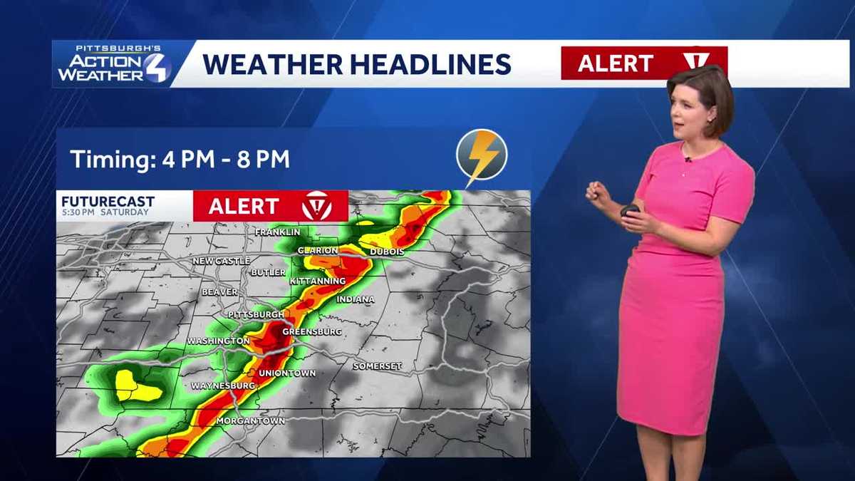
EVERYBODY. I’M ANDREW STOCKEY. AND THAT’S PITTSBURGH’S ACTION SPORTS FROM PITTSBURGH’S ACTION SPORTS TO PITTSBURGH’S ACTION WEATHER 4. LET’S GET YOU ANOTHER CHECK OF THAT CERTIFIED MOST ACCURATE FORECAST. WE HAD THE MOST GORGEOUS SUNRISE THIS MORNING. GREAT OUT THERE. NOW UNFORTUNATELY THIS AFTERNOON THOUGH, THINGS TAKE A LITTLE SHIFT, RIGHT? YEAH. WITH ALL THE WARMTH, THE WIND THAT’S COMING OUR WAY TODAY, WE’RE GOING TO COOK UP SOME STRONGER THUNDERSTORMS LATER ON THIS AFTERNOON. SO THAT’S WHY IT IS A SEVERE WEATHER ALERT DAY. NOT GOING TO BE AN ALL DAY AFFAIR. YOU GET TO ENJOY MOST OF YOUR SATURDAY. BUT A HEADS UP AFTER ABOUT THREE 4:00, ESPECIALLY AS YOU’RE UP CLOSER TO NEWCASTLE AROUND DINNER TIME, THINGS WILL BE BUSIER IN AND AROUND THE CITY OF PITTSBURGH, AS WILL I. A LINE OF STRONGER THUNDERSTORMS MIXED IN SOME STRONG, DAMAGING WINDS. SOME BRIEF DOWNPOURS. WE’LL ALL BE ALONG FOR THE RIDE RIGHT NOW. A FEW ISOLATED SPLASH AND DASH SHOWERS, EVEN A FEW RUMBLES OF THUNDER WORKING THROUGH JEFFERSON, NORTHEASTERN INDIANA COUNTIES. THAT’S IT RIGHT NOW WE’LL KEEP THINGS QUIET ON THE RADAR FOR THE NEXT SEVERAL HOURS, BUT AGAIN, IT STILL IS A SEVERE WEATHER ALERT DAY DURING THE TIME BEING, WHILE WE WAIT FOR THE STRONGER STORMS, WE’RE BRINGING IN SOME RECORD WARMTH TODAY. 76 OUR FORECAST HIGH. THAT IS THE RECORD TO DATING BACK TO 1983. ALONG FOR THE RIDE TO SOME STRONGER WIND GUSTS COULD BE EXCEEDING 30MPH. AND THIS EVEN OUTSIDE OF THUNDERSTORMS TODAY. THEN TEMPERATURES BACK OFF BRIEFLY, ONLY AROUND 60 FOR YOUR SUNDAY AS WE SPRING FORWARD LATE TONIGHT BACK INTO THE 70S THAT WILL LAST THROUGH WEDNESDAY, WHICH IS ANOTHER IMPACT DAY FOR US. AND THEN AGAIN, KIND OF A LITTLE BIT OF A REALITY CHECK. SECOND HALF OF NEXT WEEK. FOR THE TIME BEING. WE’RE FOCUSED ON OUR FIRST ROUND OF SEVERE WEATHER OF THE SEASON. EVERYBODY HAS THE CHANCE TO SEE SOME SCATTERED, STRONG AND SEVERE THUNDERSTORMS THROUGH THE AFTERNOON AGAIN LEADING THE WAY, DAMAGING WINDS, EVEN SOME BRIEF DOWNPOURS, NOT NECESSARILY GOING TO PRODUCE ANY FLOODING CONCERNS. AT LEAST STORMS WILL MOVE SO FAST ACROSS WESTERN PENNSYLVANIA, BUT STILL SKIES WILL OPEN UP FOR A PERIOD OF TIME AND A LOW END RISK HAIL. EVEN A BRIEF SPIN UP TORNADO, SOMETHING THAT WE CANNOT OVERLOOK AS WE WORK INTO THE AFTERNOON. SO BETWEEN NOW ABOUT 3:00, YOU’RE FINE. GET OUTSIDE AND ENJOY. JUST DON’T AWAY AGAIN. WINDS ARE GOING TO BE A LITTLE BIT STRONGER AS WE KICK UP THOSE TEMPERATURES INTO THE MID. EVEN UPPER 70S, AS WE WORK TOWARDS THE 4:00 HOUR. STORMS ARE SHOWING UP IN BEAVER NEW CASTLE. ALSO PARTS OF VENANGO COUNTIES THAT WILL SLICE INTO ALLEGHENY COUNTY. BUSY TIME FRAME FOR US AT LEAST. CLOSE TO THE CITY OF PITTSBURGH, WILL BE BETWEEN ABOUT FOUR AND 6:00. THAT LINE CONTINUES TO PROGRESS EASTWARD. SHOULD BE CLEARING THE LAUREL HIGHLANDS BY THE TIME WE HIT 8:00. THEN JUST SOME LEFTOVER SHOWERS POSSIBLE AS WE GO THROUGH THE OVERNIGHT HOURS, BUT THINGS WILL BE MUCH QUIETER WHILE YOU’RE SLEEPING LATE TONIGHT AGAIN, BEFORE THOSE STORMS GET HERE, WE’RE GOING TO BRING IN SOME BREEZY CONDITIONS. GUSTS COULD EXCEED 30MPH. NOT AS WARM TOMORROW AS WE SPRING FORWARD. WILL SLOWLY BRING BACK SOME OF THAT SUNSHINE INTO THE AFTERNOON, AND WE’LL ENJOY MORE OF THAT DAYLIGHT SUN DOESN’T GO DOWN UNTIL 720 TOMORROW NIGHT. THE REST OF YOUR 4-DAY PLUS 4 MORE FORECAST WILL KEEP THOSE TEMPERATURES IN THE 70S. GREAT DAY ON MONDAY, WARMER ON TUESDAY. RELATIVELY QUIET THERE. NEXT IMPACT DAY IS ON WEDNESDAY. LOOKS TO BE AN ALL DAY AFFAIR WITH RAIN. EVEN AN ISOLATED THUNDERSTORM CAN’T BE RULED OUT. IT’S GOING TO BE BREEZY AS EVENTUALLY A BIT MORE OF A REALITY CHECK COMES IN. SECOND PART OF NEXT WEEK. EVEN A FEW WET SNOWFLAKES ON THE TAIL END OF THAT SYSTEM POSSIBLE. THURSDAY MORNING, A HIGH OF ONLY 46 TEMPERATURES WILL BOUNCE AROUND THE 50 DEGREE MARK AS WE HEAD INTO NEXT WEEKEND, BUT RIGHT NOW, THINGS LOOK QUIET DRY FOR THE PITTSBURGH SAINT PATRICK’S DAY PARADE NEXT SATURDAY, S
Severe T’storm Threat Ends This Eve…Cooler/Dry Tomorrow
Storm Threat Ends by early eve….Sun to end the weekend

Updated: 3:57 PM EST Mar 7, 2026
The t’storm threat will end by sunset…with lingering clouds and maybe a leftover spotty shower as a cool front passes overnight. Clocks “spring forward,” temperatures dropDaylight Saving Time begins at 2 a.m. Sunday. It is time to turn the clocks ahead one hour. However, temperatures will dip slightly behind the passing front. Highs will only warm close to 60 degrees. Clouds will gradually give way to more sunshine by the afternoon. It will also remain breezy to wrap up the weekend.Sunny Start to Week with Warming TempsA Sun-sational start to the new week. Lotsa of sun expected Monday and only a few clouds will mix with the sun on Tuesday. Temperatures will quickly rebound to near 70 on Monday and into the low 70s Tuesday.The next threat for showers will arrive Wednesday, which is also an Impact Day, as another cold front swings in. It will be breezy with more scattered showers expected.We will return to more seasonal territory by late week.TONIGHT: Storms fizzle, leftover shower overnight. Mostly cloudy, low: 48°.SUNDAY: Clouds then Sun. Comfortable. High: 60°, low: 44°.MONDAY: Sunny and pleasant. High: 68°, low: 52°.TUESDAY: Clouds & Sun. Warm. High: 72°, low: 60°.
PITTSBURGH —
The t’storm threat will end by sunset…with lingering clouds and maybe a leftover spotty shower as a cool front passes overnight.
Clocks “spring forward,” temperatures drop
Daylight Saving Time begins at 2 a.m. Sunday. It is time to turn the clocks ahead one hour. However, temperatures will dip slightly behind the passing front. Highs will only warm close to 60 degrees. Clouds will gradually give way to more sunshine by the afternoon. It will also remain breezy to wrap up the weekend.

Hearst OwnedHearst
Not as warm Sunday with the return of sunshine.
Sunny Start to Week with Warming Temps
A Sun-sational start to the new week. Lotsa of sun expected Monday and only a few clouds will mix with the sun on Tuesday. Temperatures will quickly rebound to near 70 on Monday and into the low 70s Tuesday.
The next threat for showers will arrive Wednesday, which is also an Impact Day, as another cold front swings in. It will be breezy with more scattered showers expected.
We will return to more seasonal territory by late week.

Hearst OwnedHearst
Springtime warmth runs through Wednesday, which is our next Impact Day. Temperatures will turn more seasonal late next week.
TONIGHT: Storms fizzle, leftover shower overnight. Mostly cloudy, low: 48°.
SUNDAY: Clouds then Sun. Comfortable. High: 60°, low: 44°.
MONDAY: Sunny and pleasant. High: 68°, low: 52°.
TUESDAY: Clouds & Sun. Warm. High: 72°, low: 60°.