
Western PA: Dry days to start the week
The next rain chance is Wednesday, which is an Impact Day.
I’M ASHLEY OATES. AND THAT’S PITTSBURGH’S ACTION SPORTS. SWITCHING TO PITTSBURGH’S ACTION WEATHER. NOW OF COURSE WE FEEL LIKE WE’VE BEEN SPOILED AT LEAST FOR SATURDAY. OF COURSE WE HAD THOSE STORMS LATE SATURDAY NIGHT. BUT OF COURSE, FROM WHAT WE WERE HEARING, WE CAN’T PUT AWAY THE SWEATERS JUST YET. RIGHT, JOE? RIGHT. WE GOT SOME COOLER TEMPERATURES, BUT WE ALSO GOT A LITTLE BIT OF A SPRING FLING. AND THAT IS BREWING. AS WE ENTER THE BRAND NEW WEEK, TEMPERATURES TAKE A LITTLE BIT OF A STEP BACK TODAY OFF OF THAT RECORD WARMTH YESTERDAY. AND OF COURSE THE STORMS TO THE BREEZE ONLY MAKES IT FEEL MORE COMFORTABLY COOL. BUT THOSE SPRING TEMPERATURES WORKING RIGHT BACK IN. JUST AS WE KICK OFF A BRAND NEW WORK AND SCHOOL WEEK. OF COURSE, IT ALSO LEADS TO MORE RAIN TOO. THAT’S FOR WEDNESDAY, WHICH IS AN IMPACT DAY, SO MONITORING A FEW TEENY TINY SHOWERS CONTINUE TO HANG ON NOW THROUGH PARTS OF FAYETTE AND ALSO ON GALLIA COUNTIES. BUT THEY’RE GOING TO BE BRIEF, SHORT LIVED AS A WEAK BOUNDARY IS SETTLING THROUGH. THAT’S WHAT’S DROPPING THOSE TEMPERATURES FOR US HERE ON YOUR SUNDAY. ALSO PICKING UP A BIT A BIT OF A BREEZE RIGHT NOW. THE WEST NORTHWEST AT 17MPH TEMPERATURE. MEANWHILE, PITTSBURGH INTERNATIONAL 50 UNDER THOSE CLOUDY SKIES. HERE’S YOUR 4-DAY PLUS 4 MORE FORECAST MAY NOT SEEM LIKE IT NOW, BUT WE WILL GET BACK MORE SUNSHINE BY THIS AFTERNOON. STAYS BREEZY. CERTAINLY COOLER THAN YESTERDAY. 59 OUR HIGH. THEN WE WERE CLOSER TO 70 MONDAY WITH ALL DAY SUNSHINE. TUESDAY WARMEST DAY OF THE WEEK 74. STILL HANGING ON TO THE 70S FOR THAT IMPACT DAY WEDNESDAY, BUT NUMBERS WILL BE SLIDING WITH ANOTHER STRONG COLD FRONT THAT USHERS IN THAT RAIN POSSIBILITY. EVEN A FEW SPRINGTIME STORMS THERE GO THE CLOUDS WILL BE WORK IN PROGRESS HERE OVER THE NEXT COUPLE OF HOURS TO BRIGHTEN THINGS UP. BUT OF COURSE, NOW WITH THE TIME CHANGE, WE EXTEND OUR DAYLIGHT TIME THAT WILL GO THROUGH 7:00 THIS EVENING AND TEMPERATURES WILL CONTINUE TO CLIMB AS WELL. LATER ON TONIGHT, UNDER CLEAR AND CALM CONDITIONS, WE COULD SEE SOME AREAS OF PATCHY FOG FORMING. FUTURE CAST STILL HOLDING ON TO A LOT OF THAT ACTIVITY FROM THE CITY OF PITTSBURGH ON SOUTH, EVEN THROUGH PARTS OF WESTMORELAND COUNTY. SO SOMETHING TO BE MINDFUL OF AS YOU’RE OUT THE DOOR IN THE MORNING. IT’S STILL GOING TO BE DARK INTO THE 7:00 HOUR. SO WE WILL SEE A CHILL IN THE AIR. TWO AS WE WORK THROUGH THE DAY. PLENTY OF SUNSHINE. TEMPERATURES CLIMB INTO THE LOW EVEN MID 60S ACROSS THE REGION AND WE ONLY CONTINUE TO WARM AS WE FAST FORWARD INTO TUESDAY. THAT’S MY PICK OF THE WEEK. TEMPERATURES START OFF IN THE LOW 50S, LOW TO MID 70S. BY THE AFTERNOON. THAT’S ACROSS THE BOARD FOR WESTERN PENNSYLVANIA. CERTAINLY UNSEASONABLY WARM FOR THIS TIME OF THE YEAR. WE WILL SEE AN UPTICK IN CLOUD COVER AS WE WORK THROUGH THE AFTERNOON. BUT WE KEEP THINGS DRY NOW TUESDAY, WEDNESDAY, DIFFERENT STORY AS THAT STRONG COLD FRONT MOVES IN. LOOKS TO BE SOME STEADY RAIN AROUND FOR PARTS OF THE MORNING. WE COULD CATCH A BREAK INTO THE AFTERNOON THAT WILL GIVE THE ATMOSPHERE SOME TIME TO CHARGE UP AS THAT FRONT APPROACHES. SO COULD BE TALKING ABOUT AGAIN. ANOTHER ROUND OF THUNDERSTORMS WILL BE MONITORING THE TIMING AND THE SETUP AS WE GET INTO THE UPCOMING WEEK. WHAT WE WILL SEE BEHIND THAT FRONT IS A DROP IN TEMPERATURES, SO THERE’S ENOUGH MOISTURE LEFT BEHIND. COULD SEE A FEW FLURRIES POSSIBLY THURSDAY MORNING. ONLY 44 FOR A HIGH. THAT’S GOING TO BE A SHOCK TO THE SYSTEM AFTER THE LOW 70S. WEDNESDAY BACK INTO THE 50S. FRIDAY MID TO UPPER 40S FOR SAINT PATRICK’S DAY WEEKEND. BEST NEWS OF ALL. THINGS ARE GOING TO BE QUIET AND DRY FOR US. LUCKILY, IRISH SMILING ON US JUST IN TIME FOR THE PITTSBURGH SAINT PATRICK’S DAY PARADE. TEMPERATURES, THOUGH MORE THAN LIKELY CLOSE TO 40 AS THE PARADE STEPS OFF AROUND 10:00 NEXT SATURDAY. JUST WHEN YOU THINK YOU’RE OUT OF T
Western PA: Dry days to start the week
The next rain chance is Wednesday, which is an Impact Day.

Updated: 10:02 AM EDT Mar 8, 2026
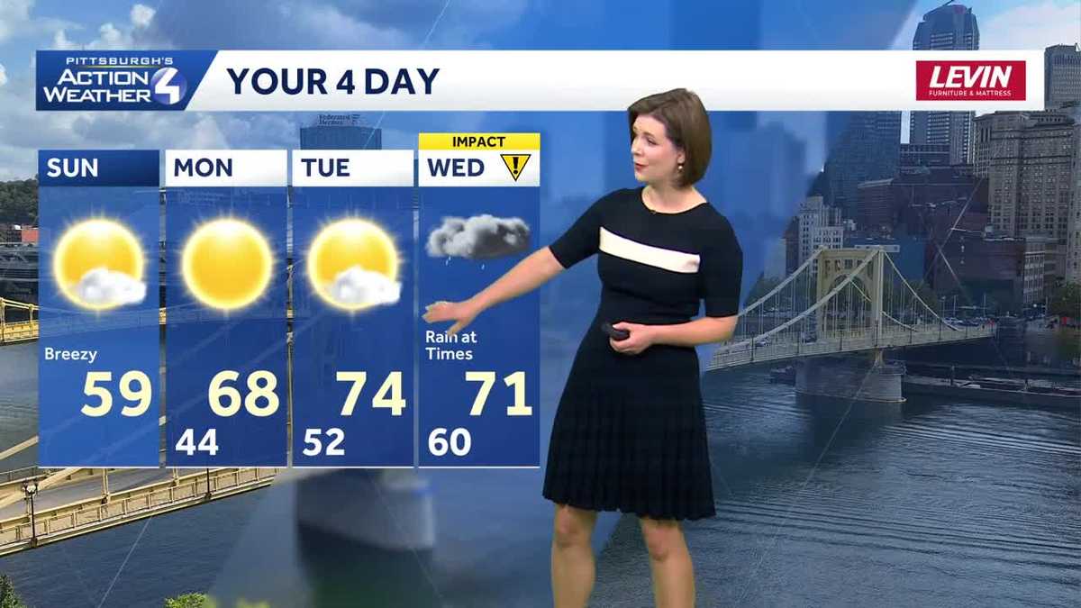
The weekend ends on a dry note with a gradual return to sunshine and highs around 60 degrees. The spring-like weather is not over yet for western Pennsylvania. Highs surge well into the 70s Tuesday before more rain for the middle of the week.”Springing forward” to cooler temperaturesTemperatures dip after yesterday’s record warmth. A breeze will hold readings to the upper 50s this afternoon. More sunshine works in as the days goes on.Clear and chilly overnight with lows dropping back into the 40s. Patchy valley fog will form ahead of sunrise.Spring surgeNo Monday blues in the forecast with plenty of sunshine tomorrow. Temperatures will trend closer to 70 degrees and even warmer on Tuesday. We will see more clouds throughout the day on Tuesday ahead of our next system.Impact Day on Wednesday for rainAnother cold front will swing in on Wednesday with periods of rain, prompting an Impact Day. Steady rain is possible during the morning commute. We will monitor the possibility of a thunderstorm or two late in the day. This front will dramatically drop temperatures with highs going from the low 70s Wednesday to just the 40s on Thursday. A flurry or two may sneak in on the tail end.Temperatures trend more seasonal late next week with highs in the 40s and 50s. The outlook is dry for the Pittsburgh St. Patrick’s Day parade on Saturday.TODAY: Clouds then sun. Breezy and comfortable. High: 59°.TONIGHT: Fair skies with patchy fog, low: 44°.MONDAY: Sunny and pleasant. High: 68°, low: 52°.TUESDAY: Warmer with gradually increasing clouds. High: 74°, low: 60°.WEDNESDAY – Impact Day: Rain at times. High: 71°, low: 36°.
PITTSBURGH —
The weekend ends on a dry note with a gradual return to sunshine and highs around 60 degrees. The spring-like weather is not over yet for western Pennsylvania. Highs surge well into the 70s Tuesday before more rain for the middle of the week.
“Springing forward” to cooler temperatures
Temperatures dip after yesterday’s record warmth. A breeze will hold readings to the upper 50s this afternoon. More sunshine works in as the days goes on.

Hearst OwnedHearst
Comfortable around western Pennsylvania with highs near 60 degrees under sunshine this afternoon.
Clear and chilly overnight with lows dropping back into the 40s. Patchy valley fog will form ahead of sunrise.
Spring surge
No Monday blues in the forecast with plenty of sunshine tomorrow. Temperatures will trend closer to 70 degrees and even warmer on Tuesday. We will see more clouds throughout the day on Tuesday ahead of our next system.

Hearst OwnedHearst
Another spring surge is on the way with highs peaking in the mid 70s on Tuesday.
Impact Day on Wednesday for rain
Another cold front will swing in on Wednesday with periods of rain, prompting an Impact Day. Steady rain is possible during the morning commute. We will monitor the possibility of a thunderstorm or two late in the day. This front will dramatically drop temperatures with highs going from the low 70s Wednesday to just the 40s on Thursday. A flurry or two may sneak in on the tail end.

Hearst OwnedHearst
Wednesday is an Impact Day for periods of rain and the potential for isolated storms.
Temperatures trend more seasonal late next week with highs in the 40s and 50s. The outlook is dry for the Pittsburgh St. Patrick’s Day parade on Saturday.

Hearst OwnedHearst
Trending more seasonal for mid-March after Wednesday’s rain.
TODAY: Clouds then sun. Breezy and comfortable. High: 59°.
TONIGHT: Fair skies with patchy fog, low: 44°.
MONDAY: Sunny and pleasant. High: 68°, low: 52°.
TUESDAY: Warmer with gradually increasing clouds. High: 74°, low: 60°.
WEDNESDAY – Impact Day: Rain at times. High: 71°, low: 36°.