
Mainly clear overnight; milder trend to start the week across south-central Pennsylvania
In addition to the much milder weather, we’re watching an unsettled pattern that will allow more chances for showers by the middle of the week.
IS BELOW AT $3.51. NOW, THE WGAL NEWS EIGHT STORM TEAM FORECAST, WITH METEOROLOGIST RYAN ARGENTE. THE WEATHER HEADLINES FOR THE REST OF THE NIGHT. TONIGHT WE’RE SEEING SKIES ALREADY BEGINNING TO CLEAR AS THIS COLD FRONT THAT WAS SLOWLY MAKING ITS WAY THROUGH THE SUSQUEHANNA VALLEY IS FINALLY MOVING OUT, AND IT’S ALLOWING OUR SKIES TO CLEAR FOR THIS EVENING. GETTING INTO TONIGHT SO EARLY THOUGH, INTO THE WEEK, WE’RE LOOKING AT SOME MORE SUNSHINE WITH WARMER TEMPERATURES GETTING INTO THE 60S FOR TOMORROW 70 BY THE TIME WE GET TO TUESDAY, AND ALSO WEDNESDAY WILL BE RETURNING DOWN TO SEASONABLE AVERAGES THOUGH, ALONG WITH AN UNSETTLED PATTERN AS WE HEAD INTO THE MIDDLE TO END OF THIS WORKWEEK. SO WE’LL CHAT ABOUT THAT HERE IN JUST A SECOND. BUT HERE’S LET’S COVER THE STATISTICS FOR THE DAY. TODAY HIT A HIGH OF 67 DEGREES 48. THAT’S WHAT WE EXPECT FOR THIS TIME OF YEAR. SO JUST SHY OF THAT, 20 DEGREES ABOVE AVERAGE, YOU MIGHT AS WELL ROUND IT TO 20 DEGREES ABOVE AVERAGE FOR THIS TIME OF YEAR. AND THEN 43. THAT WAS EARLIER THIS MORNING. THAT WAS EARLIER THIS MORNING’S LOW 30 DEGREES IS WHAT WE EXPECT. DIDN’T HAVE ANY RAINFALL AT HARRISBURG INTERNATIONAL AIRPORT. BUT THE FORECAST FOR THE REST OF THE NIGHT TONIGHT, EXPECT CLEAR SKIES TO PERSIST. COOLER CONDITIONS 34 TO 38 DEGREES WITH LIGHT WINDS OUT OF THE SOUTHWEST. AND THEN FOR TOMORROW MORNING, MOSTLY SUNNY. IT WILL BE A QUICK WARM UP, THOUGH. 42 TO 46 DEGREES TO START YOUR MONDAY MORNING COMMUTE. AND THEN WE’LL SEE SOME INCREASING WINDS OUT OF THE SOUTHWEST BETWEEN 5 AND 10MPH. THEN EVENTUALLY ELEVATE TO AROUND 5 TO 15MPH FOR THE MIDDLE OF THE AFTERNOON. BUT LOOK AT THE TEMPERATURES HERE 66 TO 70 DEGREES WITH WARM AND PLEASANT. WILL BE MOSTLY SUNNY FOR THE AFTERNOON, SO IF YOU HAPPEN TO HAVE SOME TIME OR TIME OFF AND YOU WANT TO SPEND SOME TIME OUTDOORS, THERE YOU GO. THIS IS DEFINITELY A GOOD TIME TO TO GET OUTDOORS AND NOT ONLY JUST FOR TOMORROW, BUT LOOK AT TUESDAY AND WEDNESDAY, GETTING INTO THE 70S, 74 FOR OUR TUESDAY, 72 FOR WEDNESDAY, AND THEN WE’RE BACK DOWN TO SEASONAL AVERAGES FOR THURSDAY AND FRIDAY, 50 DEGREES FOR THURSDAY. 52 IS WHAT WE’RE FORECASTING FOR THE END OF THE WEEK. WHAT’S ALSO GOING TO BE INCREASING ALONG WITH THOSE TEMPERATURES ARE THE PRECIPITATION CHANCES OVER THE NEXT SEVERAL DAYS. NOW WE’RE DRY FOR MONDAY AND TUESDAY, SO NO NEED TO WORRY ABOUT ANY ANY RUINED PLANS IN TERMS OF RAIN. BUT ONCE WE GET TO LATE WEDNESDAY INTO THURSDAY, WE’RE WATCHING A STORM SYSTEM THAT’S GOING TO START TO MOVE THROUGH AND ALLOW FOR THOSE RAIN CHANCES TO GO UP. SO WE’RE GOING TO BE WATCHING FOR THE MIDDLE OF THE WEEK. AND AS WE GET INTO THE WEEKEND, SOME SLIGHT PRECIPITATION CHANCES, BUT THE REMAINING LOW AT THIS TIME. SO THE NEXT BEST CHANCES ARE FOR THE MIDDLE OF THE WEEK, TEMPERATURES INTO THE 40S. NOW WE’RE 51. IN LANCASTER, A WARM SPOT IN LEBANON, 61 DEGREES, 59 IN GETTYSBURG, 47 IN CARLISLE AT THIS TIME. SO A SCATTERED RANGE OF TEMPERATURES AT THIS HOUR. STORM TEAM, LIVE RADAR NETWORK. ALL IS QUIET RIGHT NOW. IT’S ALL THANKS TO HIGH PRESSURE THAT’S BUILDING IN IN THE WAKE OF THIS COLD FRONT THAT IS NOW PUSHING OUT OF THE SUSQUEHANNA VALLEY. SO HERE’S HERE’S THAT HIGH PRESSURE JUST TOWARDS OUR SOUTHWEST. THAT’S CLOSE ENOUGH TO THE SUSQUEHANNA VALLEY TO ALLOW FOR THE MAINLY CLEAR CONDITIONS FOR OVERNIGHT TONIGHT, GETTING INTO TOMORROW, YOU CAN SEE CLEAR SKIES AS WE GET INTO THE EVENING FOR MONDAY. WE’LL SEE. POSSIBLY SOME CLOUDS BEGIN TO BUBBLE UP AS WE GET INTO OUR TUESDAY MORNING AND TUESDAY AFTERNOON. BUT I WILL SAY HIGH PRESSURE DOES WIN OUT, AND IT’S GOING TO HELP US, TO HELP US TO STAY CLEAR FOR THE MOST PART AS WE GET INTO OUR TUESDAY. SO HERE’S OUR TEN DAY FORECAST INTO THE 70S. AS WE GET INTO OUR TUESDAY AND OUR WEDNESDAY. BUT I DID PUT THAT SHOWER ICON THERE FOR OUR FOR THE CHANCE OF SOME SHOWERS LATE IN THE DAY. NOW AGAIN, WE’RE WATCHING. IT’S A COLD FRONT THAT’S GOING TO MOVE THROUGH AND ALLOW FOR SOME SHOWERS TO HAPPEN LATE OVERNIGHT WEDNESDAY INTO EARLY THURSDAY. THEN WE DROP DOWN TO THE 50S. YOU CAN SEE THE STRENGTH OF THAT COLD FRONT WILL REALLY ALLOW US TO DROP BACK DOW
Mainly clear overnight; milder trend to start the week across south-central Pennsylvania
In addition to the much milder weather, we’re watching an unsettled pattern that will allow more chances for showers by the middle of the week.

Updated: 11:21 PM EDT Mar 8, 2026
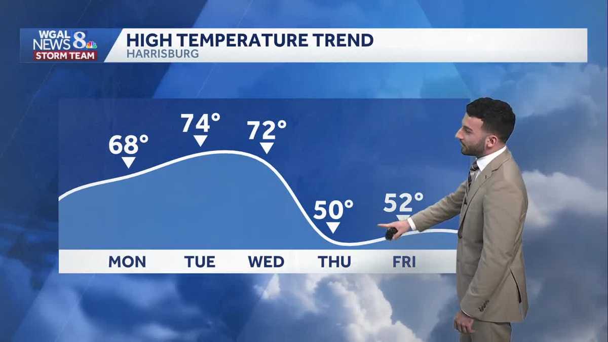
In the wake of a cold front that crossed through the area, skies have cleared and winds have diminished to a calm breeze. Temperatures will continue dropping to the 30s tonight under mainly clear skies.To start the work week, expect abundant sunshine and mostly sunny skies for the morning commute. We’ll be in the 40s to start, then quickly warm to the upper 60s by the middle of Monday afternoon. Winds will elevate for a short time during the afternoon, then calm once again later toward evening.More sunshine is on tap Tuesday & it’ll be warmer in the low to mid 70s! As a side note, the record is 79°, which was set back in 2016. Clouds will increase late in the day.A stronger cold front will approach on Wednesday, bringing showers across the Susquehanna Valley by evening. It is still warm with highs reaching the low 70s. The record is 76 set back in 2021.Shower threat ends late morning Thursday. The warmest temperatures are very early, in the low 50s, then they drop into the 40s. Winds will be blustery too.A few showers are possible Friday into Saturday; otherwise, expect typical temperatures for mid-March, in the upper 40s to low 50s at the end of the week.
In the wake of a cold front that crossed through the area, skies have cleared and winds have diminished to a calm breeze. Temperatures will continue dropping to the 30s tonight under mainly clear skies.
To start the work week, expect abundant sunshine and mostly sunny skies for the morning commute. We’ll be in the 40s to start, then quickly warm to the upper 60s by the middle of Monday afternoon. Winds will elevate for a short time during the afternoon, then calm once again later toward evening.
More sunshine is on tap Tuesday & it’ll be warmer in the low to mid 70s! As a side note, the record is 79°, which was set back in 2016. Clouds will increase late in the day.
A stronger cold front will approach on Wednesday, bringing showers across the Susquehanna Valley by evening. It is still warm with highs reaching the low 70s. The record is 76 set back in 2021.
Shower threat ends late morning Thursday. The warmest temperatures are very early, in the low 50s, then they drop into the 40s. Winds will be blustery too.
A few showers are possible Friday into Saturday; otherwise, expect typical temperatures for mid-March, in the upper 40s to low 50s at the end of the week.