
The new week is off to a beautiful start with sunshine and warming temperatures. Wednesday has been upgraded to a Severe Weather Alert Day for up to an inch of rain and another round of strong afternoon thunderstorms.Back-to-back days of sunshine and warming temperaturesIt is clear and comfortably cool to head out the door this morning. Grab your sunglasses with plenty of sunshine on tap throughout the day. Temperatures will climb into the upper 60s to around 70 degrees. It will be a few degrees warmer tomorrow. More clouds and a stray shower are possible late Tuesday.Severe Weather Alert Day WednesdayWednesday is now a Severe Weather Alert Day for rain at times and another round of strong thunderstorms. A strong cold front will push up to an inch of rain and the threat of scattered strong storms. The afternoon and evening hours will feature the best chance for thunderstorms. Damaging winds and large hail are the primary threats.This front will dramatically drop temperatures with highs going from the low 70s Wednesday to just the 40s on Thursday. Early rain showers, even a flurry in spots, are possible Thursday morning.Feeling more like mid-MarchTemperatures trend more seasonal late next week with highs in the 40s and 50s. The outlook is dry but brisk for the Pittsburgh St. Patrick’s Day parade on Saturday. The chillier pattern will extend into the start of next week.TODAY: Pleasant with plenty of sunshine. High: 68°.TONIGHT: Clear and not as chilly. Low: 52°.TUESDAY: Warmer with more clouds late and a stray shower north. High: 72°, low: 60°.WEDNESDAY – Severe Weather Alert Day: Rain at times with a few stronger late-day thunderstorms. High: 71°, low: 36°.THURSDAY: Colder with lingering early morning rain showers. High: 42°, low: 32°.
PITTSBURGH —
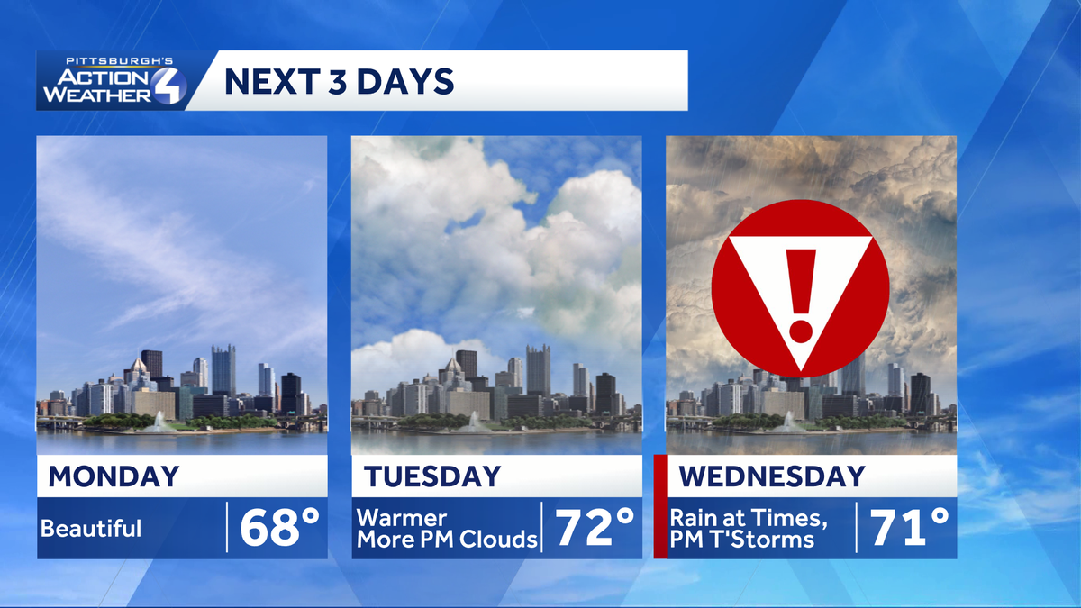
The new week is off to a beautiful start with sunshine and warming temperatures. Wednesday has been upgraded to a Severe Weather Alert Day for up to an inch of rain and another round of strong afternoon thunderstorms.
Back-to-back days of sunshine and warming temperatures
It is clear and comfortably cool to head out the door this morning. Grab your sunglasses with plenty of sunshine on tap throughout the day. Temperatures will climb into the upper 60s to around 70 degrees. It will be a few degrees warmer tomorrow. More clouds and a stray shower are possible late Tuesday.
Severe Weather Alert Day Wednesday
Wednesday is now a Severe Weather Alert Day for rain at times and another round of strong thunderstorms. A strong cold front will push up to an inch of rain and the threat of scattered strong storms. The afternoon and evening hours will feature the best chance for thunderstorms. Damaging winds and large hail are the primary threats.
This front will dramatically drop temperatures with highs going from the low 70s Wednesday to just the 40s on Thursday. Early rain showers, even a flurry in spots, are possible Thursday morning.
Feeling more like mid-March
Temperatures trend more seasonal late next week with highs in the 40s and 50s. The outlook is dry but brisk for the Pittsburgh St. Patrick’s Day parade on Saturday. The chillier pattern will extend into the start of next week.
TODAY: Pleasant with plenty of sunshine. High: 68°.
TONIGHT: Clear and not as chilly. Low: 52°.
TUESDAY: Warmer with more clouds late and a stray shower north. High: 72°, low: 60°.
WEDNESDAY – Severe Weather Alert Day: Rain at times with a few stronger late-day thunderstorms. High: 71°, low: 36°.
THURSDAY: Colder with lingering early morning rain showers. High: 42°, low: 32°.