
What to KnowA FIRST ALERT is in effect on Wednesday for the Philadelphia region from 3 p.m. through 11 p.m. due to severe storms that will bring damaging winds, heavy rain, hail and the threat of an isolated tornado. Before the severe weather, conditions will be beautiful Tuesday evening into Wednesday morning with temperatures in the 70s. After the storms move out late Wednesday, temperatures will fall with temperatures in the 30s by Thursday night. Be sure to get the latest weather updates by downloading the NBC10 app and following the NBC10 First Alert Weather team.
After a stretch of sunshine and warm temperatures, we’re in for more severe weather Wednesday afternoon through Wednesday night.
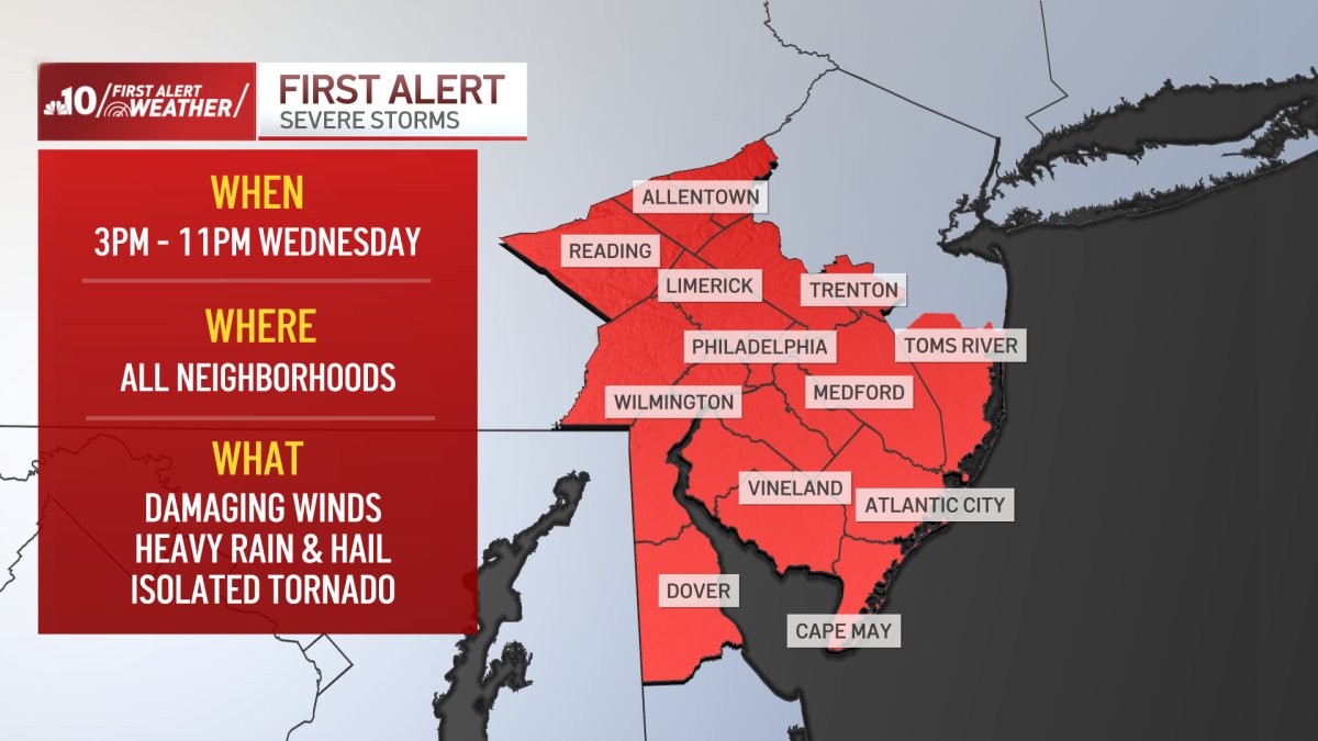
A FIRST ALERT is in effect for the Philadelphia region on Wednesday from 3 p.m. to 11 p.m. due to storms that will bring damaging winds, heavy rain, hail and the threat of an isolated tornado. Here’s what we can expect.

Beautiful sunny weather Tuesday ahead of severe storm threat
Tuesday is beautiful, with temperatures in the upper 70s and low 80s. There will be plenty of sunshine for all neighborhoods. Tuesday night, however, temperatures will drop into the 50s.
Strong to severe storms threaten all of our neighborhoods Wednesday
We have another day with a southwesterly breeze on Wednesday, which will give us one more afternoon with temperatures in the 70s. However, the pattern starts to change, and clouds will move in early Wednesday morning.
Peaks of sunshine will be limited Wednesday afternoon, and showers and storms will approach Berks County and the Lehigh Valley as early as noon.
Showers and storms are possible after 3 p.m. throughout southeast Pennsylvania. Showers and storms will likely roll through the city late afternoon from west to east.
This weather is likely to move into New Jersey by dinner time and could reach the shore by 8 p.m.
While not every neighborhood will see storms, the threat of severe weather is present in all neighborhoods. If a severe storm is warned, damaging winds are the main threat.
The chance for hail or even a tornado is low but not zero.
The Storm Prediction Center has most of the region in green or a Level 1 of 5 risk. This means that a storm or two could be severe. Out west, in the yellow category (level 2), scattered storms could turn severe.
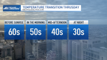
End of the springlike weather Thursday
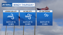
Once the storms and showers end by midnight, the temperature transition begins. On Thursday, temperatures will be in the 60s before sunrise, 50s in the morning, and 40s by the afternoon. There will also be a chilly breeze with gusts up to 30 miles per hour.
Friday starts cold in the low 30s in the city and temperatures will reach near 51 degrees during the afternoon. During the weekend, temperatures will be in the mid-50s with more peaks of sunshine on Saturday and a cloudier setup on Sunday.
Be sure to get the latest weather updates by downloading the NBC10 app and following the NBC10 First Alert Weather team.