
IMPACT WEDNESDAY: Thunderstorms to bring heavy rain, lightning, gusty winds to south-central Pa.
MIGHT HAVE SAID. WHATEVER. THERE. IT’S KIND OF THE UNFINISHED STORY. THERE YOU GO. LIVES ON. THAT’S VERY INTERESTING. YOU MENTIONED THERE DURING THE STORY, WE HEARD ONE OF THE FOLKS SAY, A BEAUTIFUL DAY FOR THAT PROJECT. YEAH, GREAT DAY OUT THERE ACROSS THE SUSQUEHANNA VALLEY. IN FACT, RECORD WARMTH ACROSS THE VALLEY. TEMPERATURES INSTEAD OF LIKE, MAY LIKE WE WERE DISCUSSING MORE LIKE EARLY JUNE OUT THERE. AND WE WILL MAKE A RUN AT THE RECORD HIGH AGAIN TOMORROW. TEMPERATURES WILL TOP OFF IN THE LOW TO MID 70S. THE RECORD HIGH TOMORROW IS 76. WE WILL BE CLOSE TO THAT, BUT WE WILL SEE SHOWERS AND THUNDERSTORMS. TAP INTO THIS NEAR RECORD WARMTH AND BECAUSE IT’S SO WARM OUT THERE WITH THE INCREASING HUMIDITY, SOME OF THOSE STORMS COULD BE STRONG TO SEVERE. SO THAT’S WHY TOMORROW IS AN IMPACT DAY. ENJOY THE WARMTH WHILE IT LASTS, BECAUSE BY THE TIME WE MAKE IT INTO THURSDAY WILL BE BACK DOWN CLOSER TO AVERAGE AND IT’S GOING TO BE EVEN COLDER EARLY NEXT WEEK FOR SAINT PATRICK’S DAY HIGH TODAY, OFFICIALLY 80 DEGREES. THAT BEATS THE OLD RECORD OF 79 SET BACK IN 2016. STARTED THE DAY OFF, THOUGH IN THE 30S IT’S STILL NEAR 80 ACROSS MUCH OF THE SUSQUEHANNA VALLEY. WE’RE AT 79 RIGHT NOW IN LANCASTER WITH MOSTLY SUNNY SKIES, BUT WE ARE SEEING SOME CLOUDS DEVELOP AND ALSO SOME SHOWERS BLOSSOM IN THIS NEAR RECORD WARMTH THAT’S OUT THERE. ACROSS THE VALLEY. YOU CAN SEE SOME SHOWERS ON LIVE RADAR, AND THE STORM TEAM LIVE RADAR NETWORK. THEY’RE NOT VERY STRONG AND THERE ARE FEW IN NUMBER. JUST A LITTLE DOWNPOUR RIGHT NOW OVER SOUTH MOUNTAIN, JUST TO THE NORTH THERE OF WAYNESBORO IN EASTERN PORTIONS OF FRANKLIN COUNTY. SOME SPOTTY SHOWERS RIGHT NOW IN PARTS OF PERRY COUNTY. JUNIATA COUNTY, RIGHT THERE JUST TO THE WEST OF THE 22 322 CORRIDOR. SO MORE CLOUDS ARE DUE IN THESE ISOLATED SHOWERS WILL TAPER OFF LATER TONIGHT. SO JUST A FEW SHOWERS IN OUR WESTERN COMMUNITIES WITH TEMPERATURES IN THE 70S TO UPPER 60S. LOWS TONIGHT. VERY WARM FOR THIS TIME OF YEAR, ONLY DROPPING TO THE LOWER 50S. AND THEN FOR TOMORROW WE’LL HAVE SOME ROUNDS OF SHOWERS AND THEN SCATTERED SHOWERS AND THUNDERSTORMS ARE LIKELY DURING THE AFTERNOON AS WE TOP OFF IN THE LOW TO MID 70S, BUT SOME OF THOSE STORMS COULD BE SEVERE. SO THE WINDOW OF OPPORTUNITY STARTS TO OPEN UP. I’D SAY AFTER 1:00 AND WILL LAST UNTIL 11:00. IT IS A LEVEL TWO OUT OF FIVE, SO A LOW CHANCE WE COULD SEE THESE STRONG THUNDERSTORMS COULD CAUSE SOME TRAVEL AND POWER DISRUPTIONS. THE MAIN CONCERN IS STORMS THAT PRODUCE DAMAGING WIND GUSTS, BUT IT’S POSSIBLE WE COULD SEE A BRIEF SPIN UP TORNADO AND ALSO SOME HAIL. NOT LOOKING FOR FLASH FLOODING BECAUSE WE’VE BEEN SO DRY. 79 FOR YOU FOLKS RIGHT NOW IN HERSHEY AT 76 IN HARRISBURG, STILL 80 IN HANOVER AND 77 IN LEWISTOWN, YOU CAN SEE THAT WARMTH EXTENDS OFF TO OUR WEST AND STILL 83 DEGREES IN KANSAS CITY. BUT DROPPING INTO THE 30S OVER THE DAKOTAS, THAT CLASH OF THE WARM AND THE COLD. YOU CAN SEE WE HAVE TORNADO WATCHES IN EFFECT FOR PARTS OF ILLINOIS DOWN INTO OKLAHOMA AND PARTS OF TEXAS. LOT OF STORM ENERGY WORKING ITS WAY TO THE EAST, TAPPING IN TO THIS INCREDIBLY WARM AIR THAT IS SITTING OVERHEAD. SO WATCH WHAT HAPPENS HERE ON THE PREDICTOR. THERE YOU CAN SEE THOSE SPOTTY SHOWERS FIZZLE OUT BY THE TIME WE GET TO MIDNIGHT. AND THEN TOMORROW MORNING, I DO EXPECT WE WILL SEE SOME CLOUDS AND SOME SPOTTY SHOWERS. NOW, THE MORE CLOUDS WE GET, THE MORE RAIN WE GET IN THE MORNING. THAT COULD KEEP THE LID ON, SO TO SPEAK, FOR THE THREAT, FOR SEVERE WEATHER, FOR TOMORROW AFTERNOON, TOMORROW EVENING. BUT IF WE SEE MORE SUNSHINE AND FEWER SHOWERS AND STORMS, THAT COULD INCREASE THE THREAT FOR SCATTERED SHOWERS AND THUNDERSTORMS. WORST WEATHER TOMORROW, LIKELY OVER WESTERN PENNSYLVANIA. BUT THAT’S WHAT’S GOING TO BE MOVING ON IN DURING THE EVENING RUSH HOUR. THE HIGHEST CHANCES FOR US FOR THESE STRONGER THUNDERSTORMS STILL COULD SEE SOME ISOLATED STRONG THUNDERSTORMS AS LATE AS 11:00. BUT THEN THIS FRONT MOVES ON BY AND THAT WILL DROP THE TEMPERATURES. WE’LL STILL HAVE SOME SHOWERS AROUND EARLY ON THURSDAY MORNING, BUT WE SHOULD DRY BACK OUT BY THURSDAY AFTERNOON. SO MID 70S FOR TOMORROW, POSSIBLY SOME STRONG TO SEVERE THUNDERSTORMS. AND THEN DOWN GO THE TEMPERATURES CLOSER TO AVERAGE WITH ISOLATED SHOWERS POSSIBLE FOR YOUR FRIDAY AND SATURDAY. BETTER CHANCES FOR SHOWERS AROUND SUNDAY INTO MONDAY AND
IMPACT WEDNESDAY: Thunderstorms to bring heavy rain, lightning, gusty winds to south-central Pa.

Updated: 7:09 PM EDT Mar 10, 2026
A strong cold front will bring rain showers and the potential for strong to severe thunderstorms on Wednesday across south-central Pennsylvania. The WGAL News 8 Storm Team has declared Wednesday an Impact Day, meaning the day features weather that will likely disrupt your normal daily schedule or routine. What to expectWednesday morning: A few rain showers are possible around 8 a.m. Afternoon: Showers and thunderstorms move into the Susquehanna Valley from west to east; could be strong to severe. Early evening: A brief break from the rain is possible. Evening commute through midnight: A cold front moves through, bringing another round of scattered showers and thunderstorms, with isolated strong to severe storms possible.Overnight into Thursday morning: Showers and thunderstorms may linger into the overnight hours and early Thursday.Thursday: Behind the front, temperatures drop, and it turns much colder. Thunderstorm riskThe Storm Prediction Center (SPC) placed the entire Susquehanna Valley under a Slight Risk (Level 2 of 5) for strong to severe thunderstorms. A strong cold front and powerful upper-level winds will move toward the Mid-Atlantic, with humid air reaching into Pennsylvania.Main threatsDamaging wind gusts from organized lines of thunderstorms, along with frequent lightning and brief heavy downpours. The risk for tornadoes and large hail is low.TemperaturesTuesday night: Lows in the low 50s with increasing clouds. Wednesday: Highs in the low to mid 70s (The record high is 76, set in 2021). Lows in the mid-40s. Thursday: Turning cooler with highs in the upper 40s and lows in the upper 20s. What we’re tracking Morning/early-day storms could limit heating and instability, reducing the overall severe potential. The storms are expected to weaken as they move east. If we’re cloudy and see more rain in the morning, that will lower the chances for stronger storms overall. WGAL weather linksWatch it: Use WGAL’s interactive radar to track storms.Get alerts that follow you: Turn on location-based weather alerts with WGAL’s step-by-step instructions.Check what’s closed: See closings and delays for businesses, churches, and organizations during severe weather.Navigate smarter: Open WGAL’s interactive traffic map for crashes, construction, and road closures—with traffic cameras.Inbox updates: Sign up for email alerts, from daily forecasts to severe-weather warnings.Plan by the hour: View the hour-by-hour forecast for your day.Weekend ready: Preview the weekend forecast before you lock in plans.Look ahead: Browse the 10-day forecast for the extended outlook.
A strong cold front will bring rain showers and the potential for strong to severe thunderstorms on Wednesday across south-central Pennsylvania.
The WGAL News 8 Storm Team has declared Wednesday an Impact Day, meaning the day features weather that will likely disrupt your normal daily schedule or routine.
What to expectWednesday morning: A few rain showers are possible around 8 a.m. Afternoon: Showers and thunderstorms move into the Susquehanna Valley from west to east; could be strong to severe. Early evening: A brief break from the rain is possible. Evening commute through midnight: A cold front moves through, bringing another round of scattered showers and thunderstorms, with isolated strong to severe storms possible.Overnight into Thursday morning: Showers and thunderstorms may linger into the overnight hours and early Thursday.Thursday: Behind the front, temperatures drop, and it turns much colder.

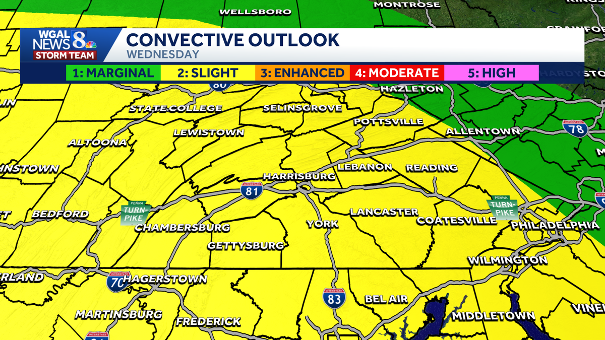
Thunderstorm risk
The Storm Prediction Center (SPC) placed the entire Susquehanna Valley under a Slight Risk (Level 2 of 5) for strong to severe thunderstorms.
A strong cold front and powerful upper-level winds will move toward the Mid-Atlantic, with humid air reaching into Pennsylvania.


Main threatsDamaging wind gusts from organized lines of thunderstorms, along with frequent lightning and brief heavy downpours. The risk for tornadoes and large hail is low.


TemperaturesTuesday night: Lows in the low 50s with increasing clouds. Wednesday: Highs in the low to mid 70s (The record high is 76, set in 2021). Lows in the mid-40s. Thursday: Turning cooler with highs in the upper 40s and lows in the upper 20s.

What we’re tracking
Morning/early-day storms could limit heating and instability, reducing the overall severe potential.
The storms are expected to weaken as they move east. If we’re cloudy and see more rain in the morning, that will lower the chances for stronger storms overall.

WGAL weather links