
Wednesday is a Severe Weather Alert Day as heavy rain, severe storms and gusty winds are expected throughout the day in Western Pennsylvania. WATCH THE LATEST FORECAST FROM PITTSBURGH’S ACTION WEATHER IN THE VIDEO ABOVEA strong cold front will bring periods of heavy rain and push up to an inch of rain. There could be up to three rounds of rain and storms through the day..The first round arrived for the morning rush hour. A second round that was tracking through the region around lunchtime will be more isolated, with a better opportunity for thunder north of the city of Pittsburgh.The final round of rain and storms could pack more of a punch. Thunderstorms should arrive after 5 p.m. and could be stronger to severe. The biggest threats are heavy downpours and damaging winds, but hail or an isolated tornado cannot be ruled out.The final batch of rain is tied to a cold front. Rain will exit by midnight, with temperatures dropping into Thursday.FEELING MORE LIKE MID-MARCHThe front will dramatically drop temperatures for the second half of the week. Instead of the 60s and 70s, we will only manage the 40s Thursday. A few wet snowflakes could fly in the Laurel Highlands early Thursday morning.Temperatures trend more seasonal late next week with highs in the 40s and 50s. Isolated rain showers are possible again on Friday.ST. PATRICK’S DAY PARADE OUTLOOKThe outlook is dry but brisk for the annual St. Patrick’s Day parade in downtown Pittsburgh on Saturday. The chillier pattern will extend into the start of next week.Another cold front will arrive Monday morning, bringing rain, lower temperatures and a transition to some snowflakes. As of now, little to no accumulation is expected.
PITTSBURGH —
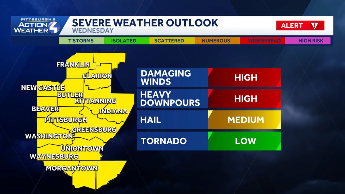
Wednesday is a Severe Weather Alert Day as heavy rain, severe storms and gusty winds are expected throughout the day in Western Pennsylvania.
WATCH THE LATEST FORECAST FROM PITTSBURGH’S ACTION WEATHER IN THE VIDEO ABOVE
A strong cold front will bring periods of heavy rain and push up to an inch of rain. There could be up to three rounds of rain and storms through the day..
The first round arrived for the morning rush hour. A second round that was tracking through the region around lunchtime will be more isolated, with a better opportunity for thunder north of the city of Pittsburgh.
The final round of rain and storms could pack more of a punch. Thunderstorms should arrive after 5 p.m. and could be stronger to severe. The biggest threats are heavy downpours and damaging winds, but hail or an isolated tornado cannot be ruled out.

The final batch of rain is tied to a cold front. Rain will exit by midnight, with temperatures dropping into Thursday.
FEELING MORE LIKE MID-MARCH
The front will dramatically drop temperatures for the second half of the week. Instead of the 60s and 70s, we will only manage the 40s Thursday. A few wet snowflakes could fly in the Laurel Highlands early Thursday morning.
Temperatures trend more seasonal late next week with highs in the 40s and 50s. Isolated rain showers are possible again on Friday.
ST. PATRICK’S DAY PARADE OUTLOOK
The outlook is dry but brisk for the annual St. Patrick’s Day parade in downtown Pittsburgh on Saturday. The chillier pattern will extend into the start of next week.
Another cold front will arrive Monday morning, bringing rain, lower temperatures and a transition to some snowflakes. As of now, little to no accumulation is expected.
