
National Weather Service issues tornado watch
DISAPPEAR BEHIND SOME CLOUDS. LET’S GET AN UPDATE ON THE CHECK ON THE FORECAST WITH METEOROLOGIST ETHAN HOUSTON. ETHAN, WHAT ARE WE LOOKING AT TO KEEP YOUR GUARD UP AS WE GO THROUGH THIS EVENING? WE DO HAVE THE THREAT FOR THE STRONG TO SEVERE THUNDERSTORMS. THAT’S WHY IT IS AN ALERT DAY. AS WE GO INTO THE END OF THE WEEK, TEMPERATURES WILL START TO DROP, BUT WE WILL SEE MORE WET WEATHER COMING. WITH THIS COLDER WEATHER. METEOROLOGIST RYAN JAY INSLEE WILL HAVE MORE ON THAT IN JUST A FEW MINUTES. WE DO HAVE A TORNADO WATCH NOW IN EFFECT FOR ALL OF THE SUSQUEHANNA VALLEY COUNTIES. THAT IS UNTIL 8:00. HERE’S WHAT’S GOING ON. WE HAVE A LOT OF SPIN IN THE ATMOSPHERE, AND WE HAVE MODERATE FUEL. SO WHAT WE’RE WATCHING OUT FOR MOSTLY ARE STORMS THAT PRODUCE DAMAGING WIND GUSTS. SO SEVERE THUNDERSTORM WARNINGS. BUT BECAUSE OF THE ELEVATED THREAT, THE HIGHER THAN USUAL RISK FOR TORNADOES, THAT’S WHY WE HAVE A TORNADO WATCH. STILL NOT GOING TO RULE OUT SOME STORMS THAT PRODUCE SOME HAIL BECAUSE IT IS COLD. AS YOU GET UP TO THE TOPS OF THESE THUNDERSTORMS. BUT TAKING A LIVE LOOK RIGHT NOW, THIS IS ACTUALLY HERSHEY, NOT GETTYSBURG. YOU CAN SEE THE CLOUDS ARE THICK OUT THERE, BUT WE ARE SEEING SOME PEEKS OF SUNSHINE AND WE ARE MONITORING THIS LINE OF STORMS NOW MOVING INTO OUR WESTERN COUNTIES, WE DO HAVE ONE ACTIVE SEVERE THUNDERSTORM WARNING NOW THAT STORM IS STILL BACK IN HUNTINGDON COUNTY, BUT THE SEVERE THUNDERSTORM WARNING IS IN EFFECT FOR PARTS OF JUNIATA AND MIFFLIN COUNTIES. THAT IS UNTIL 515, POSSIBLY WINDS UPWARDS OF 60MPH. IT ACTUALLY HIT THE GAUGE, THE WIND GAUGE OR THE THE WEATHER GAUGE OUT THERE AT ALTOONA AIRPORT. SO THAT’S WHY IT’S CONSIDERED OBSERVED AS IT WORKS ITS WAY TO THE EAST. SO HERE’S A TIMELINE ON THAT. IT WILL BE APPROACHING REEDS GAP BY ABOUT 511 TOWARDS PORT ROYAL AT 527, A DECENT DOWNPOUR AND POSSIBLY A GUESS AGAIN, EXCESS OF 60MPH. ELSEWHERE ACROSS THE VALLEY, SOME SCATTERED SHOWERS AND ISOLATED THUNDERSTORMS. HERE’S A CELL MOVING THROUGH NORTHERN PORTIONS OF DAUPHIN COUNTY JUST NOW TO THE EAST OF HALIFAX AND ELIZABETHVILLE MORE HEAVIER DOWNPOURS NOW WORKING THEIR WAY OUT OF FRANKLIN COUNTY AND INTO WESTERN PORTIONS OF ADAMS COUNTY, INTO SOUTHWESTERN PORTIONS OF CUMBERLAND COUNTY. SO THIS LINE IS STARTING TO FORM AND IT IS WORKING ITS WAY TO THE EAST. AND THERE ARE MORE SHOWERS AND THUNDERSTORMS BACK OFF TO OUR WEST. SO WATCH WHAT HAPPENS HERE ON THE PREDICTOR, YOU CAN SEE NUMBER OF SHOWERS AND THUNDERSTORMS. 7:00 POSSIBLY SOME HEAVIER BANDS IN LANCASTER COUNTY AND INTO BERKS COUNTY. GOING TO SOUND AT LEAST THE CLEAR FOR THE THREAT OF SEVERE WEATHER AFTER NINE, BUT MAY SEE ISOLATED, STRONGER THUNDERSTORMS AS LATE AS MIDNIGHT. AND THAT’S WHEN A COLD FRONT STARTS TO MOVE ON BY. STILL SOME SHOWERS BE AROUND ON INTO THURSDAY MORNING, SO KEEP YOUR GUARD UP FOR THE THREAT FOR THESE STRONG THUNDERSTORMS. POSSIBLY SEVERE WITH TEMPERATURES STARTING TO FALL INTO THE 60S AFTER SUNSET, THUNDERSTORMS WILL TAPER BACK TO SOME SCATTERED SHOWERS. AND THEN FOR TOMORROW I EXPECT TEMPERATURES WILL ACTUALLY BE COOLER LATER IN THE DAY. SO THAT 48 COULD BE EARLIER IN THE DAY. AND WITH THIS BIG COOL DOWN AND HOW FAR THOSE TEMPERATURES DROP AND WHEN WE COULD SEE MORE RAIN AFTER THIS EVENING. HERE’S METEOROLOGIST RYAN ARGENT. THANKS, ETHAN. YES, WE’RE GOING TO BE DEALING WITH A BIG COOLDOWN AS THAT COLD FRONT STARTS TO MOVE THROUGH. HERE’S SOME OF THE OBSERVED HIGHS FOR THE DAY TODAY. 76 AT HARRISBURG INTERNATIONAL AIRPORT 75 IN LEWISTOWN, 77 IN CARLISLE. BUT LOOK AT THE 80S DOWN TOWARDS YORK, GETTYSBURG AND CHAMBERSBURG. IT IS VERY WARM AND VERY HUMID OUT THERE, FOLKS. IT’S BEEN ALLOWING. THAT’S WHAT’S BEEN FUELING THESE THUNDERSTORMS TODAY SO FAR THIS AFTERNOON. BUT I WANT TO SHOW YOU OTHER CURRENT TEMPERATURES OUTSIDE OF HARRISBURG BEING RIGHT AROUND 76 DEGREES. PITTSBURGH 68, CHARLESTON 79. BUT LOOK TOWARDS DAYTON AND LOUISVILLE 61 AND 71, RIGHT BEHIND THE COLD FRONT IN THE WAKE OF IT LEAVING 30S BEHIND 40 ANOTHER AND OTHER OTHER CITIES AS WHAT WE’RE WATCHING AS WE GET INTO THE NEXT, AS WE GET INTO THE NEXT 12 TO 18 HOURS HERE AND YOU CAN SEE HIGH TEMPERATURES THESE NEXT SEVERAL DAYS AFTER THAT COLD FRONT BLOWS THROUGH. LOOK AT THIS DOWN, BACK DOWN TO SEASONABLE AVERAGES TO 48 DEGREES FOR TOMORROW. 50S AS WE GET INTO OUR FRIDAY AND SATURDAY, THEN SLIGHTLY ELEVATING ABOVE SEASONABLE LEVELS RIGHT AROUND 54 DEGREES FOR THE SECOND HALF OF THIS UPCOMING WEEKEND. BUT YOU SEE, AS THIS COLD FRONT STARTS TO PUSH THROUGH. YOU CAN SEE THE PREDICTOR IS HIGHLIGHTING IS A LITTLE BIT OF SOME SNOW THAT IS THINKING, I WILL SAY I’M GOING TO MAKE A NOTE HERE. IT IS HIGHLY UNLIKELY THAT WE SEE SNOW WITH THIS COLD FRONT THAT’S GOING TO START TO PUSH THROUGH. IF ANYTHING, WE’RE GOING TO SEE ANY PRECIPITATION. IT’S GOING TO BE IN THE FORM OF SHOWERS. SO IF YOU SEE ANY PRECIPITATION FOR TOMORROW MORNING THAT’S WHAT IT’S GOING TO BE. SO IN THE WAKE OF THAT COLD FRONT LATER INTO THURSDAY EVENING, YOU SEE SOME CLEARING BEHIND THAT COLD FRONT GOING THROUGH THURSDAY NIGHT INTO EARLY FRIDAY MORNING. STILL SEEING SOME CLEARING. THEN WE’LL START TO INCREASE IN THAT CLOUD COVER AS OUR NEXT SYSTEM STARTS TO PUSH THROUGH AND ALLOW ANOTHER CHANCE OF SOME SCATTERED SHOWER ACTIVITY LATER ON FOR OUR FRIDAY EVENING. SO HERE’S OUR TEN DAY FORECAST DOWN INTO THE 40S. WILL GO FOR THURSDAY, GETTING INTO THE 50S FOR OUR FRIDAY AND SATURDAY WILL BE BLUSTERY FOR OUR FRIDAY, CALMER FOR OUR SATURDAY SHOWERS LATE IN THE DAY FOR OUR SUNDAY. ANOTHER CHANCE FOR SOME SHOWERS ON MONDAY WILL BE COLDER AND BLUSTERY FOR YOUR TUESDAY OR
The National Weather Service has extended the area for a tornado watch in South Central Pennsylvania.Live video above: Watch WGAL News 8.The watch is now in effect for the entire Susquehanna Valley until 8 p.m.:Adams CountyCumberland CountyDauphin CountyFranklin CountyJuniata CountyLancaster CountyLebanon CountyMifflin CountyPerry CountyYork CountyWatches vs warningsKnowing the difference between severe watches and warnings is crucial to helping you and your family stay safe before and during severe weather.A watch means ingredients are in place for severe weather to develop. This means severe weather could happen, and you should have a plan ready in case severe weather develops later in the day.A warning means severe weather is happening, and you need to take action now to protect yourself, others and your property.In addition to watches and warnings, there are outlooks that can be issued days in advance. Different threat levels are given to different areas.Ready, get set, goREADY | If your town is in a severe outlook, be ready. Pay attention to the forecast in the coming hours and days, as severe weather may be possible.GET SET | If a severe weather watch is issued for your town, that means ingredients are present for severe weather to occur. Severe weather is going to be possible.GO | A severe warning has been issued. That means severe weather is happening now. Take cover.WGAL weather linksWatch it: Use WGAL’s interactive radar to track storms.Get alerts that follow you: Turn on location-based weather alerts with WGAL’s step-by-step instructions.Check what’s closed: See closings and delays for businesses, churches, and organizations during severe weather.Navigate smarter: Open WGAL’s interactive traffic map for crashes, construction, and road closures—with traffic cameras.Inbox updates: Sign up for email alerts, from daily forecasts to severe-weather warnings.Plan by the hour: View the hour-by-hour forecast for your day.Weekend ready: Preview the weekend forecast before you lock in plans.Look ahead: Browse the 10-day forecast for the extended outlook.
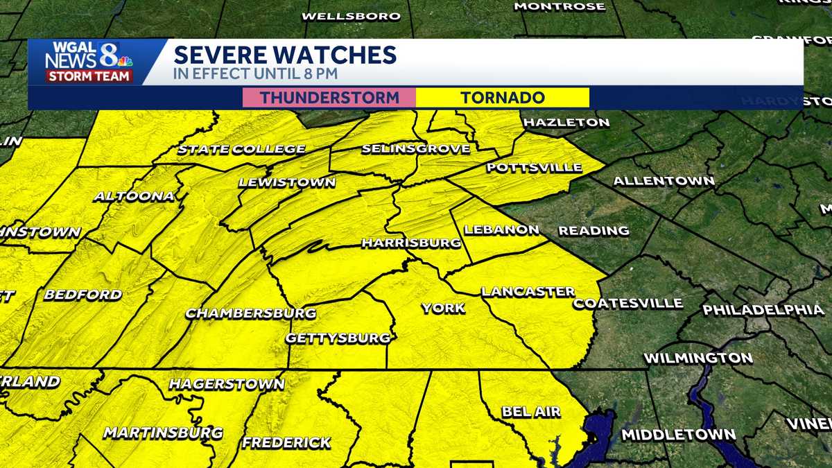
The National Weather Service has extended the area for a tornado watch in South Central Pennsylvania.
Live video above: Watch WGAL News 8.
The watch is now in effect for the entire Susquehanna Valley until 8 p.m.:
Adams CountyCumberland CountyDauphin CountyFranklin CountyJuniata CountyLancaster CountyLebanon CountyMifflin CountyPerry CountyYork County

Watches vs warnings
Knowing the difference between severe watches and warnings is crucial to helping you and your family stay safe before and during severe weather.
A watch means ingredients are in place for severe weather to develop. This means severe weather could happen, and you should have a plan ready in case severe weather develops later in the day.
A warning means severe weather is happening, and you need to take action now to protect yourself, others and your property.
In addition to watches and warnings, there are outlooks that can be issued days in advance. Different threat levels are given to different areas.
Ready, get set, go
READY | If your town is in a severe outlook, be ready. Pay attention to the forecast in the coming hours and days, as severe weather may be possible.
GET SET | If a severe weather watch is issued for your town, that means ingredients are present for severe weather to occur. Severe weather is going to be possible.
GO | A severe warning has been issued. That means severe weather is happening now. Take cover.
WGAL weather links