
A strong system passes to our north Friday to bring some isolated showers and strong winds to Western Pennsylvania. Another system arrives Monday to change rain to snow.Impact Day Friday: Wind AdvisoryA wind advisory has been issued for the entire region at 8 a.m. Friday through 12 a.m. Saturday. Wind gusts are expected to reach up to 55 mph, making Friday an Impact Day. The strongest wind gusts will occur in the afternoon and begin to diminish once the sun sets. Everyone has a chance to see wind gusts over 50 mph. On the downslope side of the wind tomorrow in the Laurel Highlands, places like the Ligonier Valley, wind gusts could potentially top 60 mph.Weekend OutlookWe will be dry and seasonal for the Pittsburgh St. Patrick’s Day parade on Saturday. Temperatures will be in the lower 30s in the morning with upper 30s expected by the time the parade steps off in downtown Pittsburgh. Highs on Saturday will reach the 40s with the upper 60s to near 70 returning for Sunday.Monday: Impact Day with rain changing to snowAnother cold front will arrive Monday morning. Monday is an Impact Day as rain arrives during the morning commute. The cold front should clear the area around lunch with temperatures falling through the afternoon. We could drop 25° in four hours. This sudden drop will allow any leftover raindrops to change to snowflakes. There won’t be much moisture left behind the cold front, so little to no accumulation is expected. We stay chilly for the middle of next week before we warm up heading into next weekend. TONIGHT: Mostly cloudy with flurries possible north of Pittsburgh. Low: 33°FRIDAY – Impact Day: Mostly cloudy with isolated showers, especially north of Pittsburgh. Wind gusts up to 55 mph. High: 54°.SATURDAY: Partly cloudy. High: 48°, low: 30°.SUNDAY: Partly cloudy. High: 67°, low: 38°.
PITTSBURGH —
A strong system passes to our north Friday to bring some isolated showers and strong winds to Western Pennsylvania. Another system arrives Monday to change rain to snow.
Impact Day Friday: Wind Advisory
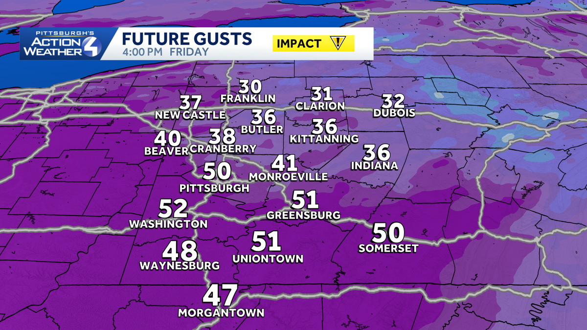
A wind advisory has been issued for the entire region at 8 a.m. Friday through 12 a.m. Saturday. Wind gusts are expected to reach up to 55 mph, making Friday an Impact Day.

The strongest wind gusts will occur in the afternoon and begin to diminish once the sun sets. Everyone has a chance to see wind gusts over 50 mph. On the downslope side of the wind tomorrow in the Laurel Highlands, places like the Ligonier Valley, wind gusts could potentially top 60 mph.

Hearst Owned
Wind gusts up to 55 mph are possible Friday afternoon.
Weekend Outlook
We will be dry and seasonal for the Pittsburgh St. Patrick’s Day parade on Saturday. Temperatures will be in the lower 30s in the morning with upper 30s expected by the time the parade steps off in downtown Pittsburgh. Highs on Saturday will reach the 40s with the upper 60s to near 70 returning for Sunday.

Monday: Impact Day with rain changing to snow
Another cold front will arrive Monday morning. Monday is an Impact Day as rain arrives during the morning commute. The cold front should clear the area around lunch with temperatures falling through the afternoon. We could drop 25° in four hours. This sudden drop will allow any leftover raindrops to change to snowflakes. There won’t be much moisture left behind the cold front, so little to no accumulation is expected.
We stay chilly for the middle of next week before we warm up heading into next weekend.

Hearst Owned
An up and down weekend with temperatures before a strong cold front arrives Monday to bring rain and snow.
TONIGHT: Mostly cloudy with flurries possible north of Pittsburgh. Low: 33°
FRIDAY – Impact Day: Mostly cloudy with isolated showers, especially north of Pittsburgh. Wind gusts up to 55 mph. High: 54°.
SATURDAY: Partly cloudy. High: 48°, low: 30°.
SUNDAY: Partly cloudy. High: 67°, low: 38°.