
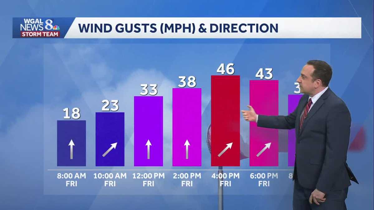
Impact: Strong gusts Friday, few showers late
Wind gusts could reach 40-45 mph at times late Friday morning through Friday evening. Isolated rain showers are possible Friday evening.
THAT’S A TRUE STORY. NO, IT’S TRUE. QUESTION. EVERYTHING ALL RIGHT? THANK YOU. I THROW IT OVER TO ETHAN HUSTON FOR A CHECK ON THE FORECAST. WHAT ARE WE IN STORE FOR TONIGHT? WELL, IT IS GOING TO BE A CALM NIGHT, BUT A COLD NIGHT. BE PREPARED FOR THE WINDS TO PICK UP TOMORROW. IT’S AN IMPACT DAY BECAUSE WE COULD SEE SOME STRONG GUSTS AT TIMES. I DO EXPECT MOST OF THE WEEKEND AHEAD IS GOING TO BE DRY, BUT THE SHOWER CHANCES WILL START RISING LATE ON SUNDAY, SUNDAY AND CONTINUE TO INCREASE THROUGHOUT THE DAY. ON MONDAY, THERE COULD BE SOME STORMS RETURN TO THE VALLEY MONDAY AS WELL, MADE IT ALL THE WAY TO 61 FOR THE HIGH TODAY, BUT THAT WAS A LITTLE AFTER MIDNIGHT. WE’VE SEEN FALLING TEMPERATURES THROUGHOUT MUCH OF THE DAY. WE HAD SOME ROUNDS OF RAIN SHOWERS, AND YOU SAW EARLIER IN THE NEWSCAST, WE HAD SOME SNOW SHOWERS IN PARTS OF LANCASTER AND YORK COUNTIES. BUT NOW IN LANCASTER WE ARE SEEING SOME SUNSHINE. BUT IT’S MISLEADING. IT IS CHILLY OUT THERE. WE’RE AT 40 DEGREES IN LANCASTER. FEELS LIKE IT’S 31. WHEN YOU FACTOR IN THE WINDS THAT ARE STIFF RIGHT NOW AT 17MPH, 43 CURRENTLY IN HARRISBURG, 42. IF YOU’RE WATCHING US IN NEW YORK, 43. ALSO IN CARLISLE, A BIG TEMPERATURE DROP COMPARED TO THIS TIME YESTERDAY WHERE YESTERDAY WE WERE DEALING WITH ACTIVE SEVERE THUNDERSTORM AND TORNADO WARNINGS. SO A BIG COOLDOWN THANKS TO A PASSING COLD FRONT VERY EARLY THIS MORNING. ALL IS QUIET NOW ON LIVE LOCAL RADAR AND I TURN ON THE SATELLITE. YOU CAN SEE WE HAVE SOME BREAKS IN THE CLOUDS THAT WILL CONTINUE TO INCREASE AS WE GO THROUGH THE NIGHT. TONIGHT, THERE GOES THE STORM SYSTEM THAT BROUGHT THE SHOWERS, THE THUNDERSTORMS, AND EVEN THE SNOW EARLY THIS MORNING. HERE’S THAT WEAK CLIPPER THAT WILL BRING SOME SPOTTY SHOWERS THROUGH THE DAY TOMORROW. BUT THE BIGGER THING IT’S GOING TO BRING ARE THOSE STRONG WIND GUSTS. SO CLEARING SKIES, DIMINISHING WINDS, TEMPERATURES IN THE MID TO UPPER 30S THIS EVENING. LOWS TONIGHT WILL BE CLOSER TO THE UPPER 20S TO 30 DEGREES. THEN FOR TOMORROW, SEASONABLE WILL TOP OFF IN THE UPPER 40S TO LOWER 50S. BUT BE PREPARED FOR THOSE STRONG WIND GUSTS AND THE THREAT FOR SOME ISOLATED RAIN SHOWERS, MOST LIKELY. BUT IF YOU’RE WATCHING THIS NORTH OF THE TURNPIKE, A FEW FLAKES MAY TRY TO MIX IN AT TIMES, BUT THOSE WINDS WILL BE IMPRESSIVE AT TIMES, ESPECIALLY TOMORROW AFTERNOON AND EARLY TOMORROW EVENING, POSSIBLY IN EXCESS OF 40MPH. THAT’S STRONG ENOUGH TO CAUSE SOME SPOTTY POWER OUTAGES. WEATHER DOES CALM DOWN FOR YOUR SATURDAY. A LITTLE BIT OF A LIGHT BREEZE FOR YOUR SATURDAY. MOST OF SUNDAY’S DRY IS JUST LATE SUNDAY EVENING INTO SUNDAY NIGHT. SHOWER CHANCES START TO RISE AGAIN. WE COULD ADD SOME THUNDERSTORMS TO THAT WITH HIGHER CHANCES FOR THOSE SHOWERS AND STORMS ON MONDAY. SO WE’VE REALLY COOLED DOWN COMPARED TO YESTERDAY, 43 RIGHT NOW IN HARRISBURG, 38 IN PITTSBURGH. IT’S THAT FAST MOVING CLIPPER THAT’S COMING IN FROM THE NORTHWEST. THAT WILL ALLOW FOR THE WINDS TO PICK UP. WE’LL HAVE MORE CLOUD COVER AND PERHAPS A FEW ISOLATED SHOWERS. SO NOTICE ON THE PREDICTOR DRY ACROSS THE VALLEY THROUGH THE AFTERNOON. ONCE WE GET CLOSER TO SUNSET MAY SEE SOME SPOTTY RAIN SHOWERS CLOSER TO I-80. MAY SEE A FEW FLAKES MIX IN. THAT WILL ALSO BE THE CASE ALONG THE RIDGE TOPS. FRONT MOVES ON BY. WE’RE DRYING BACK OUT AS HIGH PRESSURE BUILDS BACK IN FOR THE WEEKEND AGAIN. MOST OF THE WEEKEND’S WEATHER LOOKS LIKE IT IS GOING TO BE PLEASANT, BUT BE PREPARED FOR SOME SHOWERS AND THUNDERSTORMS ON MONDAY. AND THEN ANOTHER BIG TEMPERATURE DROP FOR YOUR TUESDAY, WITH HIGHS ONLY IN THE UPPER 30S. WE’RE CLOSE TO 40 DEGREES ON WEDNESDAY AND THEN TEMPERATURES SLOWLY STEP UP. BACK UP CLOSER TO AVERAGE. START OF SPRING IS NEXT FRIDAY. MAY SEE SOME SPOTTY RAIN SHOWERS. BETT
Impact: Strong gusts Friday, few showers late
Wind gusts could reach 40-45 mph at times late Friday morning through Friday evening. Isolated rain showers are possible Friday evening.

Updated: 6:29 PM EDT Mar 12, 2026
Tonight, clouds clear out and winds briefly calm with temperatures bottoming out in the upper 20s to low 30s.Friday is mainly a dry and sunny day with strong gusty winds. Gusts up to 40-45 mph are possible at times. Clouds will increase across the area during the afternoon and evening. A few showers are possible late Friday into Saturday; otherwise, expect typical temperatures for mid-March, in the upper 40s to low 50s at the end of the week.For the weekend, Saturday and Sunday are both dry & seasonable with highs in the low 50s. The wind will be less intense over the weekend as well. Shower chances return late Sunday ahead of another storm system. Shower and storm chances remain elevated Monday with temperatures rising into the upper 50s to lower 60s.Colder, drier air moves in on St. Patrick’s Day with highs potentially in the 30s and 40s, about 10 to 20 degrees below average for mid-March. This late-winter chill lingers into Wednesday and Thursday of next week with highs closer to 40 degrees. Milder, more seasonable weather returns Friday and into the start of next weekend.
Tonight, clouds clear out and winds briefly calm with temperatures bottoming out in the upper 20s to low 30s.
Friday is mainly a dry and sunny day with strong gusty winds. Gusts up to 40-45 mph are possible at times. Clouds will increase across the area during the afternoon and evening. A few showers are possible late Friday into Saturday; otherwise, expect typical temperatures for mid-March, in the upper 40s to low 50s at the end of the week.
For the weekend, Saturday and Sunday are both dry & seasonable with highs in the low 50s. The wind will be less intense over the weekend as well. Shower chances return late Sunday ahead of another storm system. Shower and storm chances remain elevated Monday with temperatures rising into the upper 50s to lower 60s.
Colder, drier air moves in on St. Patrick’s Day with highs potentially in the 30s and 40s, about 10 to 20 degrees below average for mid-March. This late-winter chill lingers into Wednesday and Thursday of next week with highs closer to 40 degrees. Milder, more seasonable weather returns Friday and into the start of next weekend.