
Isol. rain/snow showers, then clearing skies late across south-central Pennsylvania
Temperatures have dropped to the 30s & 40s today in the wake of a cold front. Drier conditions in store for the upcoming weekend
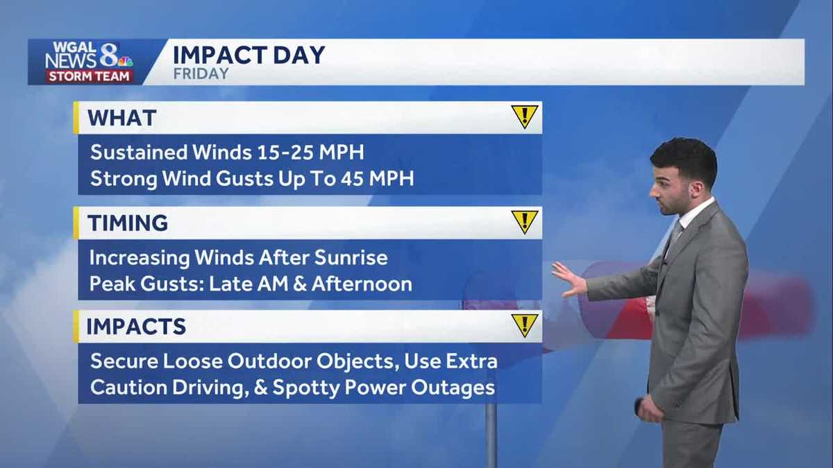
DIRECTLY TO YOUR APPLE MUSIC PLAYLIST. NOW, THE WGAL NEWS EIGHT STORM TEAM FORECAST WITH METEOROLOGIST RYAN ARGENTI. WEATHER HEADLINES FOR THE DAY TODAY. LOOKING AT SOME WET WEATHER FOR THE FIRST HALF OF THE DAY, I’D SAY SOME ISOLATED SHOWERS WITH THAT STRAY MIX. ALREADY SAW SOME REPORTS FROM SOUTHERN LANCASTER, SOUTHERN YORK COUNTIES ESPECIALLY TALKING ABOUT SAYING THERE’S A LITTLE BIT OF SNOW THAT I’M SEEING FALLING IN MY BACKYARD. SO THERE IS A LITTLE BIT OF A MIX, ALTHOUGH MAJORITY OF THE AREA NOT REALLY SEEING ANY OTHER REPORTS, ESPECIALLY TOWARDS OUR NORTHERN COMMUNITIES, BLUSTERY AND COLDER END TO THE WEEK. AND THEN AS WE HEAD INTO NEXT WEEK, WE ARE LOOKING AT SOME MORE WET WEATHER COMING ON THE HORIZON. WE’LL CHAT ABOUT THAT HERE IN JUST A COUPLE OF MINUTES. SO ISOLATED SHOWERS FOR THE DAY TODAY WITH THAT SPOTTY MIX. BUT WE’LL SEE DECREASING CLOUDS LATE IN THE DAY TODAY 44 TO 50 DEGREES. BUT NOTICE WE ARE A LITTLE BIT BREEZY TODAY AT ABOUT 10 TO 20 MILE PER HOUR. BREEZE GOT GUSTS UP TO AROUND 30MPH OUT OF THE NORTHWEST, AND THEN THEY’LL BEGIN TO SUBSIDE. LATER TONIGHT. WE’LL HAVE THOSE LIGHTER WINDS, BUT IT WILL BE CHILLY. I MEAN LOOK AT THE DIFFERENCE HERE. 28 TO 32 DEGREES. CERTAINLY WASN’T FEELING LIKE THAT YESTERDAY. WE WERE INTO THE 70S AND 80S AND IN TERMS OF THE AFTERNOON. BUT THEN TOMORROW LOOKING AT INCREASING CLOUDS AND A SPOTTY SHOWER LATE, ALTHOUGH WE ARE LOOKING AT SOME GUSTY WINDS. NOTICE LOOK AT THIS. GUSTS UP TO ABOUT 40. I’D SAY ALMOST POTENTIALLY 45MPH FOR THE AFTERNOON. WE ARE LOOKING AT AN IMPACT DAY SET FOR TOMORROW FOR THOSE WINDS. SO LET’S CHAT ABOUT THAT HERE IN JUST A MINUTE. WE HAVE TEMPERATURES INTO THE 30S. WE’RE 39 IN HARRISBURG, 38 IN LANCASTER, 39 IN LEBANON. AND WE’RE 37 IN LEWISTOWN AT THIS TIME. STILL HAVE THOSE WINDS OUT OF THE NORTHWEST. I’D SAY GENERALLY BETWEEN 15, I’D ALMOST SAY 20MPH IN SOME AREAS. AND THEN HERE’S I WANT TO SHOW YOU THE PREDICTOR. WIND GUSTS FOR TOMORROW. LOOK AT THIS. BY THE TIME WE GET TO ABOUT 4:00 OR 5:00 IN THE AFTERNOON, WE’RE SEEING COMMUNITIES GETTING UP TO ABOUT 40 45MPH IN TERMS OF WIND GUSTS OF 47 47 MILE PER HOUR WIND GUSTS FOR YORK. SO GOING TO BE A WINDY DAY TOMORROW. I KNOW IT’S GOING TO BE TRASH NIGHT TOO, SO JUST MAKE SURE YOU SECURE ANY OF YOUR LOOSE OBJECTS SUCH AS TRASH CANS. WE’RE GOING TO START TO SEE THOSE INCREASING WINDS AFTER SUNRISE. AND THEN THOSE PEAK WIND GUSTS WON’T COME UNTIL LATER IN THE MORNING AND INTO THE AFTERNOON. AGAIN, GUSTS UP TO 45MPH FOR THE AFTERNOON. SO JUST USE EXTRA CAUTION TOO WHILE YOU’RE DRIVING, ESPECIALLY IF YOU HAVE A HIGH PROFILE VEHICLE. AND ALSO WE COULD SEE SOME SPOTTY POWER OUTAGES FOR HOW, FOR HOW STRONG THOSE WINDS WILL BECOME. STORM TEAM LIVE RADAR NETWORK. IT LOOKS LIKE IT’S SNOWING ACROSS THE MAJORITY OF THE AREA, BUT I WANT TO POINT THIS OUT. WE HAVE LIVE LOCAL RADAR THAT’S HELPING TO REALLY PIN DOWN WHERE THE MAJORITY OF THAT PRECIPITATION IS ACTUALLY MAKING IT TO THE GROUND. YOU CAN SEE TOWARDS SOUTHERN YORK AND LANCASTER COUNTIES. BUT THAT’S ALL THANKS TO THIS COLD FRONT THAT’S CONTINUING TO MOVE OUT TO SEA. AND IN THE WAKE OF THAT COLD FRONT, ALLOWING SOME DRY AIR TO, TO, TO, TO START TO ENTRAIN INTO THE ATMOSPHERE AND ALLOW FOR SOME CLEARING SKIES THROUGH FRIDAY MORNING. THEN WE’LL SEE SOME INCREASING CLOUDS FOR YOUR FRIDAY AFTERNOON AND EVENING, ESPECIALLY WITH THOSE WINDY CONDITIONS. ANOTHER COLD FRONT COMES BY, GIVES US A LATE SHOWER CHANCE FOR FRIDAY, AND WE’RE LOOKING AT A DRY START TO THE FIRST HALF OF THE WEEKEND AS HIGH PRESSURE BUILDS IN AND HELPS TO KEEP OUR SKIES CLEAR. SO YOU CAN SEE TEN DAY FORECAST IMPACT DAY SET FOR FRIDAY. SEASONABLE START TO THE WEEKEND. I WILL MENTION, HOWEVER, WE ARE LOOKING AT ANOTHER CHANCE OF SOME RAIN AND POTENTIAL STORMS FOR MONDAY OF NEXT WEEK, SOMETHING WE’
Isol. rain/snow showers, then clearing skies late across south-central Pennsylvania
Temperatures have dropped to the 30s & 40s today in the wake of a cold front. Drier conditions in store for the upcoming weekend

Updated: 1:41 PM EDT Mar 12, 2026
In the wake of a cold front that has moved through the Susquehanna Valley, spotty showers have been triggered with some spots seeing a mix of rain/wet snowflakes. Warm temperatures over the past few days and early this morning will inhibit snow sticking on surfaces. Therefore, travel issues are not expected from snow that falls today. Spotty rain/snow will last through the afternoon. Temperatures have dropped to the upper 30s/lower 40s in most areas this afternoon. Winds are also elevated between 10-15 mph.Tonight, clouds clear out and the wind calms down temporarily with temperatures in the upper 20s and low 30s.Friday is mainly a dry and sunny day with strong gusty winds. Gusts up to 40-45 mph are possible at times. Clouds will increase across the area during the afternoon and evening. A few showers are possible late Friday into Saturday; otherwise, expect typical temperatures for mid-March, in the upper 40s to low 50s at the end of the week.For the weekend, Saturday and Sunday are both dry & seasonable with highs in the low 50s. The wind will be less intense over the weekend as well. Shower chances return late Sunday ahead of another storm system. Shower and storm chances remain elevated Monday with temperatures rising into the upper 50s to lower 60s.Colder, drier air moves in on St. Patrick’s Day with highs potentially in the 30s and 40s, about 10 to 20 degrees below average for mid-March. This late-winter chill lingers into Wednesday and Thursday of next week with highs closer to 40 degrees. Milder, more seasonable weather returns Friday and into the start of next weekend.
In the wake of a cold front that has moved through the Susquehanna Valley, spotty showers have been triggered with some spots seeing a mix of rain/wet snowflakes. Warm temperatures over the past few days and early this morning will inhibit snow sticking on surfaces. Therefore, travel issues are not expected from snow that falls today. Spotty rain/snow will last through the afternoon. Temperatures have dropped to the upper 30s/lower 40s in most areas this afternoon. Winds are also elevated between 10-15 mph.
Tonight, clouds clear out and the wind calms down temporarily with temperatures in the upper 20s and low 30s.
Friday is mainly a dry and sunny day with strong gusty winds. Gusts up to 40-45 mph are possible at times. Clouds will increase across the area during the afternoon and evening. A few showers are possible late Friday into Saturday; otherwise, expect typical temperatures for mid-March, in the upper 40s to low 50s at the end of the week.
For the weekend, Saturday and Sunday are both dry & seasonable with highs in the low 50s. The wind will be less intense over the weekend as well. Shower chances return late Sunday ahead of another storm system. Shower and storm chances remain elevated Monday with temperatures rising into the upper 50s to lower 60s.
Colder, drier air moves in on St. Patrick’s Day with highs potentially in the 30s and 40s, about 10 to 20 degrees below average for mid-March. This late-winter chill lingers into Wednesday and Thursday of next week with highs closer to 40 degrees. Milder, more seasonable weather returns Friday and into the start of next weekend.